The Deschutes River in central Oregon is a major tributary of the Columbia River. The river provides much of the drainage on the eastern side of the Cascade Range in Oregon, gathering many of the tributaries that descend from the drier, eastern flank of the mountains. The Deschutes provided an important route to and from the Columbia for Native Americans for thousands of years, and then in the 19th century for pioneers on the Oregon Trail. The river flows mostly through rugged and arid country, and its valley provides a cultural heart for central Oregon. Today the river supplies water for irrigation and is popular in the summer for whitewater rafting and fishing.

Devils Lake is a small lake in Lincoln County, Oregon, United States, along the Oregon Coast. It separates the northern part of Lincoln City from the Central Oregon Coast Range. It is 1/3 of a mile wide, three miles (5 km) long, and up to 21 feet (6.4 m) deep. The D River flows from the lake westward to the Pacific Ocean. At 120 feet (37 m), it is one of the world's shortest rivers.
Devil's Lake or Devils Lake may refer to:

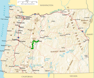
Central Oregon is a geographic region in the U.S. state of Oregon and is traditionally considered to be made up of Deschutes, Jefferson, and Crook counties. Other definitions include larger areas, often encompassing areas to the north towards the Columbia River, eastward towards Burns, or south towards Klamath Falls. These three counties have a combined population of 153,558 as of the 2000 census, with Deschutes the largest of the three counties, having approximately four times the population of the other two counties combined. As of 2015, the most populous city in the region is Bend, with an estimated 87,014 residents. As defined by the three county definition, Central Oregon covers 7,833 square miles (20,290 km2) of land. Central Oregon has had 3 record tourism years beginning in 2012. Over 2.2 million people visited Central Oregon in 2012 and again in 2013.

The Deschutes National Forest is a United States National Forest located in parts of Deschutes, Klamath, Lake, and Jefferson counties in central Oregon. It comprises 1.8 million acres (7,300 km2) along the east side of the Cascade Range. In 1908, the Deschutes National Forest was established from parts of the Blue Mountains, Cascade, and Fremont National Forests. In 1911, parts of the Deschutes National Forest were split off to form the Ochoco and Paulina National Forests, and parts of the Cascade and Oregon National Forests were added to the Deschutes. In 1915, the lands of the Paulina National Forest were rejoined to the Deschutes National Forest. A 1993 Forest Service study estimated that the extent of old growth in the forest was 348,100 acres (140,900 ha). Within the boundaries of the Deschutes National Forest is the Newberry National Volcanic Monument, containing cinder cones, lava flows, and lava tubes. The Deschutes National Forest as a whole contains in excess of 250 known caves. The forest also contains five wilderness areas, six National Wild and Scenic Rivers, the Oregon Cascade Recreation Area, and the Metolius Conservation Area. Forest headquarters are located in Bend, Oregon. There are local ranger district offices in Bend, Crescent, and Sisters.
The Cove Palisades State Park is a state park in eastern Jefferson County, Oregon, near Culver and Madras in the central part of the state, and is administered by the Oregon Parks and Recreation Department. It is located on the waters and surrounding lands of Lake Billy Chinook, an impoundment of the Crooked, Deschutes, and Metolius rivers.

Devil's Garden Volcanic Field is a volcanic field located south east of Newberry Caldera in Oregon. The lava field consists of several flows of pahoehoe lava that erupted from fissure vents in the northeast part of the Devils Garden. The main vent on the north end of the fissure created a lava tube system. Several small vents to the south produced The Blowouts, several small spatter cones, and flows. Several older hills and higher areas were completely surrounded by the flows to form kipukas. The distal ends of the flows show excellent examples of inflated lava.
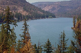
Crescent Lake is a natural lake on the eastern side of the Cascade Range in the northwest corner of Klamath County, Oregon, United States. The unincorporated community of Crescent Lake Junction on Oregon Route 58 and Crescent Lake State Airport are located 2.5 miles (4.0 km) northeast of the lake. The lake was named for its shape by Byron J. Pengra and W. H. Odell in July 1865.

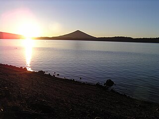
Odell Lake is located near Willamette Pass in the northwest corner of Klamath County, Oregon, United States. It is one of several lakes in the Cascade Range in Central Oregon, and lies within the Deschutes National Forest. It was named for Oregon Surveyor General William Holman Odell by Byron J. Pengra, in July 1865, while they were making a preliminary survey for the Oregon Central Military Road, which would later become Oregon Route 58. The lake fills a basin carved by a glacier, and the resulting terminal moraine confines the water along the lake's southeast shore.

The Oregon Badlands Wilderness is a 29,301-acre (11,858 ha) wilderness area located east of Bend in Deschutes and Crook counties in the U.S. state of Oregon. The wilderness is managed by the Bureau of Land Management as part of the National Landscape Conservation System and was created by the Omnibus Public Land Management Act of 2009, which was signed into law by President Barack Obama on 30 March 2009.

Wickiup Reservoir is the second-largest reservoir in the U.S. state of Oregon. It is located 60 miles (97 km) southwest of Bend, and is the largest of the Cascade Lakes. Wickiup Reservoir is close to the Twin Lakes, Davis Lake, Crane Prairie Reservoir, Cultus Lake, and Little Cultus Lake. The reservoir is located within the Deschutes National Forest and the Fort Rock Ranger District, near the Cascade Lakes Scenic Byway.
Crane Prairie Reservoir is a man-made lake located about 42 miles (68 km) southwest of Bend in Deschutes County, Oregon, United States. The reservoir is named for the cranes that thrive in its habitat and for the upper Deschutes River prairie that once covered the area before the dam on the Deschutes was constructed in 1922. Eighteen years later, in 1940, the dam was rebuilt by the Bureau of Reclamation. The reservoir now serves as one of Oregon's largest rainbow trout fisheries. The heaviest fish ever caught in the lake was a 19-pound (8.6 kg) trout.

Little Cultus Lake is a natural lake in Deschutes County, Oregon, United States. Near its larger and more popular twin Cultus Lake to the north on the other side of Cultus Mountain, it is located in the Deschutes National Forest in the Cascade Range. Like Cultus Lake, it is named after the Chinook Jargon word "cultus", meaning "in vain" or "worthless".

Elk Lake is a natural body of water in the central Cascade Range in the U.S. state of Oregon. Nearly 4,900 feet (1,500 m) above sea level, the lake is part of a volcanic landscape about 25 miles (40 km) west-southwest of Bend along the Cascade Lakes Scenic Byway.

Elliott Corbett Memorial State Recreation Site is a state park along the south shore of Blue Lake Crater in Jefferson County, Oregon, United States. The park is named in honor of Elliott R. Corbett II, who was killed while serving in the United States Army during World War II. It includes 63 acres (25 ha) of wilderness land with very few park facilities. Corbett State Park is administered by the Oregon Parks and Recreation Department.

Redmond–Bend Juniper State Scenic Corridor is a collection of ten unimproved land parcels administered for the Oregon Parks and Recreation Department. The parcels are located along U.S. Route 97 between Bend and Redmond, Oregon, United States. It is named for the large western juniper trees found on the parcels. The scenic corridor is completely undeveloped with no trails or park facilities of any kind.