Related Research Articles
Jackson County is a county in the U.S. state of Minnesota. As of the 2020 census, the population was 9,989. Its county seat is Jackson.

The wood duck or Carolina duck is a species of perching duck found in North America. The drake wood duck is one of the most colorful North American waterfowls.

Jay Norwood Darling, better known as Ding Darling, was an American cartoonist who won two Pulitzer Prizes. He was an important figure in the 20th century conservation movement and founded the National Wildlife Federation. In addition, he was known to be close friends with Walt Disney.

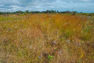
Rangelands are grasslands, shrublands, woodlands, wetlands, and deserts that are grazed by domestic livestock or wild animals. Types of rangelands include tallgrass and shortgrass prairies, desert grasslands and shrublands, woodlands, savannas, chaparrals, steppes, and tundras. Rangelands do not include forests lacking grazable understory vegetation, barren desert, farmland, or land covered by solid rock, concrete and/or glaciers.

The Arapaho National Wildlife Refuge is a United States National Wildlife Refuge located in north-central Colorado. It is one of over 560 national wildlife refuges which manages and protects natural resources for future generations. The refuge is located in North Park in central Jackson County south of the town of Walden. The refuge was established in 1967 to furnish waterfowl with a suitable place to nest and rear their young. It was created in part to offset losses of nesting habitat in the prairie wetland region of the Midwest. It is located in the valley of the Illinois River, a tributary of the North Platte River. It is administered by the United States Fish and Wildlife Service.
The Rainwater Basin wetland region is a 4,200 sq mi (11,000 km2) loess plain located south of the Platte River in south-central Nebraska. It lies principally in Adams, Butler, Clay, Fillmore, Hamilton, Kearney, Phelps, Polk, Saline, Seward, and York counties and extends into adjacent areas of southeastern Hall, northern Franklin, northern Nuckolls, western Saline, northern Thayer and northwestern Webster counties. Before European settlement, this plain was covered by prairie grasslands interspersed with thousands of ephemeral playa wetlands, called Rainwater Basins. Informally and locally, individual Nebraska Rainwater Basins are referred to as rainbasins, basins, lagoons, lakes, ponds, marshes, hay marshes, and lakes marshes. To the west, a tallgrass prairie in the east once gradually transitioned into mixed grass prairie. Currently, the Rainwater Basin wetland region is covered by farms, mainly growing corn and soybeans. Several, interspersed, stream courses, of which largest is the Big Blue River and its tributaries, drain this region. Riparian woodlands and upland slopes possessing oak woodlands are associated with these streams. In the spring and fall months, millions of migratory birds pass through the region to feed and rest. Along with riparian habitats associated Platte River, Big Blue River, its tributaries, and smaller streams, Rainwater Basins are a major component of the Central Flyway of North America.

Lake Shetek State Park is a state park of Minnesota, United States, on Lake Shetek, which is the largest lake in southwestern Minnesota and the headwaters of the Des Moines River. It is most popular for water recreation and camping. However the park also contains historical resources related to the Dakota War of 1862, including an original log cabin and a monument to 15 white settlers killed there and at nearby Slaughter Slough on August 20, 1862.
The Iowa Department of Natural Resources is a department/agency of the U.S. state of Iowa formed in 1986, charged with maintaining state parks and forests, protecting the environment of Iowa, and managing energy, fish, wildlife, land resources, and water resources of Iowa.

Inspiration Peak is a glacial feature of the Leaf Hills Moraines and of Otter Tail County in the U.S. State of Minnesota and is the second highest peak in Otter Tail County. It is 22 miles (35 km) northwest of Alexandria. The peak rises about 310 feet (94 m) above the surrounding plains, to an elevation of about 1,727 feet (526 m) above sea level. It is the central feature of Inspiration Peak State Wayside, a small recreation area maintained by the Minnesota Department of Natural Resources, which manages it from nearby Lake Carlos State Park. The wayside has a paved parking lot and a picnic area. The hike to the top is a short but strenuous walk up a well-worn trail from the parking lot. Higher terrain is located about five miles northeast of Inspiration Peak. Pekan Peak in Section 32, Folden Township, Otter Tail County, discovered by John Sandy in February 2022, at coordinates 46°11′54.744″ N 95°30′4.248″ W (DMS), Latitude 46.19854 Longitude -95.50118 (DD), has an elevation of 1,800.05 feet, measured by LiDAR technology.
Elinor Bedell State Park is a state park of Iowa, United States. It is located on the east shore of East Okoboji Lake and represents one of the last remaining open spaces on the Iowa Great Lakes. The 80-acre (32 ha) park was a gift of former U.S. Congressman Berkley Bedell and his wife Elinor.

Barringer Slough is a rich wetland area located in north east Clay County in northwestern Iowa. This area is a reconstructed remnant of the Des Moines lobe, a region of Iowa which was once covered by interconnected prairie wetlands. This wetland marsh and the surrounding public uplands cover 1,526 acres (6.18 km2). Vegetation includes cattails, coontail, sedges, marsh marigold, and duck weed. Muskrats, herons, pelicans, and ducks are also plentiful. In the winter pheasants and deer migrate onto the slough to take advantage of the vegetative cover. During periods of high water it is possible to canoe from Lost Island Lake on the north side to the outlet on the south end through a narrow channel.
The Iowa Wetland Management District is part of Union Slough National Wildlife Refuge but is very different from other wetland management districts. Under a Memorandum of Understanding with the Iowa Department of Natural Resources, the State manages many of the waterfowl production areas (WPAs) in the district. This is a partnership that has been very beneficial to the United States Fish and Wildlife Service. Together, the State and the Service have been able to develop large complexes of habitat for waterfowl and other wildlife species.

The environment of Iowa has been heavily affected by agricultural production since it became a U.S. state in 1846. However, there remain natural areas in Iowa that reflect a wide varieties of environmental niches.
Chiwaukee Prairie is a 485-acre (1.96 km2) prairie in Pleasant Prairie, Wisconsin managed by the Wisconsin Department of Natural Resources. It is located on Lake Michigan at the Illinois state line and includes grassy wetlands, wooded areas, and the Kenosha Sand Dunes at its northern tip. It is home to an abundance of wildlife. It was designated a Wisconsin State Natural Area in 1967 and a National Natural Landmark in 1973.
McPherson Valley Wetlands are a disconnected chain of marshes, wetlands, and shallow lakes in McPherson County, Kansas. Once covering a much larger area, 4,455 acres of the wetlands and surrounding prairie was protected by the Kansas Department of Wildlife, Parks, and Tourism as of 2011.

Cayler Prairie State Preserve is a 160-acre land parcel of tallgrass prairie located in the northwest region of the U.S. state of Iowa in Dickinson County near Spirit Lake. It is a National Natural Landmark.
Last Mountain Lake Bird Sanctuary is a National Historic Site of Canada, located in the rural municipality of Last Mountain Valley No. 250 in Saskatchewan. The migratory bird sanctuary was the first established in North America. The 47.36 km2 (18.29 sq mi) area is within the Last Mountain Lake National Wildlife Area, an International Biological Program site, and includes adjacent uplands.

The Western Corn Belt Plains is a Level III ecoregion designated by the Environmental Protection Agency (EPA) in seven U.S. states, though predominantly in Iowa.
References
- 1 2 3 "Dewey's Pasture Wildlife Complex is a bucket list destination". Iowa Department of Natural Resources . July 28, 2020. Retrieved 2023-05-20.
- ↑ "Dewey's Pasture BCA". Iowa Audubon Society . Retrieved 2023-05-20.
- 1 2 Rood, Lee. "DNR: Some trees must fall for important prairie habitat". Des Moines Register . Des Moines. Retrieved May 20, 2023.