The Collins River is a 67-mile-long (108 km) stream in the east-central portion of Middle Tennessee in the United States. It is a tributary of the Caney Fork, and is part of the Cumberland, Ohio and Mississippi watersheds. The river drains the scenic Savage Gulf area, located just below the river's source, and empties into Great Falls Lake at Rock Island State Park.
Historic ferries operated on rivers around Atlanta, Georgia area, and became namesakes for numerous current-day roads in north Georgia. Most of the ferries date to the early years of European-American settlement in the 1820s and 1830s, when Cherokee and other Native Americans still occupied part of what became Georgia.

The Salmon River is a 33.5-mile (53.9 km) river in the Cascade Range in the U.S. state of Oregon that drains part of southwestern Mount Hood. The entire length of the river is a protected National Wild and Scenic River. Several portions are in protected wilderness. It is affluent to the Sandy River, a tributary of the Columbia River.
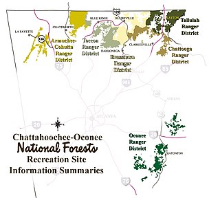
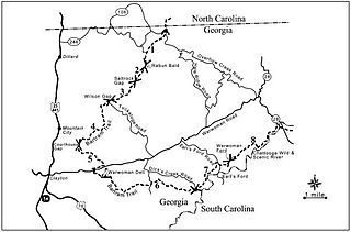
The Tallulah Ranger District is one of the five ranger districts of the Chattahoochee National Forest. The largest portion of the district is located in Rabun County, Georgia, which contains nearly 149,000 acres (600 km2). A portion of the Tallulah Ranger District is also found in Towns County. Both the Appalachian Trail and the Bartram Trail are located in the district.

Ellicott Rock Wilderness is managed by the United States Forest Service and is part of the National Wilderness Preservation System. It was first designated by Congress in 1975 with the Eastern Wilderness Act. The majority of this land lays in South Carolina. Additional lands were added to Ellicott Rock Wilderness in 1984 with the passing of the North Carolina Wilderness Act and the Georgia Wilderness Act, today designated wilderness totals 8,274 acres (33.48 km2). Ellicott Rock Wilderness is the only wilderness that straddles three states, with boundaries located around the point at which Georgia, North Carolina, and South Carolina come together. Ellicott Rock Wilderness also spans three National Forests. Sumter National Forest in South Carolina is responsible for 2,859 acres (11.57 km2), receives the majority of recreation in the wilderness, and also acts as the lead manager of Ellicott Rock Wilderness. Nantahala National Forest in North Carolina is responsible for the majority of the wilderness at 3,394 acres (13.74 km2) and the Chattahoochee National Forest in Georgia manages 2,021 acres (8.18 km2) of wilderness. In 1979, Forest Service land was surveyed under the Roadless Area Review and Evaluation and 1,982 acres (8.02 km2) adjacent to the existing wilderness were classified as Roadless National Forest System land, named Ellicott Rock Extension. The Andrew Pickens Ranger district on the Sumter National Forest recommended the Ellicott Rock Extension as wilderness in 1995 in their Resource Management Plan. In June of 2017 during a land management plan revision, the Nantahala Ranger District on the Nantahala National Forest added 824 acres (3.33 km2) of proposed wilderness, currently called Ellicott Rock West Extension.
The Soque River and its watershed are located entirely within the county boundaries of Habersham County in northeast Georgia. The Soque is a tributary of the Chattahoochee River. Portions of the river run along State Route 197.
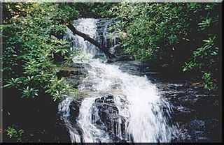
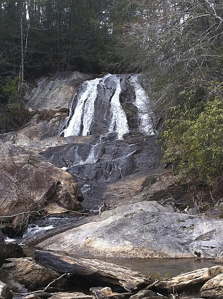
Becky Branch Falls is a twenty foot waterfall located in Rabun County, Georgia. The waterfall is located on the Bartram Trail
in a valley called Warwoman Dell, east of Clayton, Georgia. In addition to accessing the falls via the Bartram Trail at the point where the trail crosses Warwoman Road, there is a short 0.6 mile loop trail called Becky Branch Falls Trail. This alternative trail connects is also accessed at the point where the Bartram Trail crosses Warwoman Road. The Bartram Trail also continues to nearby Martin Creek Falls. Becky Branch Falls is located within the boundaries of the Chattooga River Ranger District of the Chattahoochee National Forest.
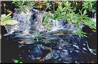
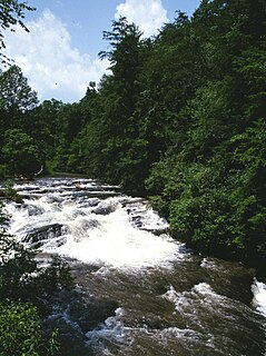
Martin Creek Falls is a series of waterfalls located in Rabun County, Georgia, with the largest drop being about 30 feet. They are located on the Bartram Trail which is a National Scenic Trail in Georgia. The falls are east of Clayton, Georgia and can be accessed by taking the Bartram Trail where it crosses Warwoman Road. The trail passes Becky Branch Falls at 200 yards and then continues on for a difficult 1.8 miles to Martin Creek Falls. Martin Creek Falls are in the Chattooga River Ranger District of the Chattahoochee National Forest.

The Great Indian Warpath (GIW)—also known as the Great Indian War and Trading Path, or the Seneca Trail—was that part of the network of trails in eastern North America developed and used by Native Americans which ran through the Great Appalachian Valley. The system of footpaths extended from what is now upper New York to deep within Alabama. Various Indians traded and made war along the trails, including the Catawba, numerous Algonquian tribes, the Cherokee, and the Iroquois Confederacy. The British traders' name for the route was derived from combining its name among the northeastern Algonquian tribes, Mishimayagat or "Great Trail", with that of the Shawnee and Delaware, Athawominee or "Path where they go armed".

The Foothills Trail is a 76-mile (122 km) National Recreation Trail in South and North Carolina, United States, for recreational hiking and backpacking. It extends from Table Rock State Park to Oconee State Park. It passes through the Andrew Pickens Ranger District of the Sumter National Forest, Ellicott Rock Wilderness, Whitewater Falls, and Lake Jocassee.

The Darebin Creek Trail is a shared use path for cyclists and pedestrians which follows Darebin Creek in the inner and outer northern suburbs of Melbourne, Victoria, Australia.
The Laverton Creek Trail is a shared use path for cyclists and pedestrians, which follows Laverton Creek in the outer western suburbs of Laverton and Altona in Melbourne, Victoria, Australia.
The Taylors Creek Trail is a shared use path for cyclists and pedestrians, which follows Taylors Creek in the outer north suburb of Taylors Lakes in Melbourne, Victoria, Australia.
U.S. Route 129 (US 129) in Florida is a north–south United States Highway. It runs 88 miles (142 km) from Chiefland north to the Georgia State Line in Levy, Gilchrist, Suwannee, and Hamilton Counties.

The path followed by the Oregon Trail, California Trail and Mormon Trail spans 400 miles (640 km) through the U.S. state of Wyoming. The trail entered from Nebraska on the eastern border of the state near the present day town of Torrington and exited on the western border near the towns of Cokeville and Afton. An estimated 350,000 to 400,000 settlers traveled on the trail through Wyoming between 1841 and 1868. All three trails follow the same path through most of the state. The Mormon Trail splits at Fort Bridger and enters Utah, while the Oregon and California Trails continue to Idaho.
State Road 249 is the state designation for U.S. Route 129 between US 27(SR 20) in Branford and US 90(SR 10) in Live Oak. It also includes a bi-county extension in Suwannee County, Florida from Live Oak across the Suwannee River to Jasper in Hamilton County.

The Yarra Trail is a shared use path for cyclists and pedestrians, which follows the Yarra River through the north eastern suburbs of Melbourne, Victoria, Australia.
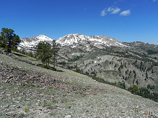
Smoky Dome, at 10,095 feet (3,077 m) above sea level is the highest peak in the Soldier Mountains of Idaho. Smoky Dome is located northwest of Fairfield in Camas County and Sawtooth National Forest.