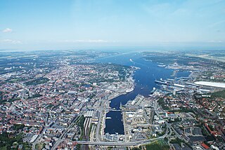
Kiel is the capital and most populous city in the northern German state of Schleswig-Holstein, with a population of 246,243 (2021).
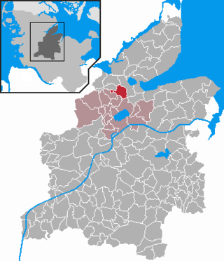
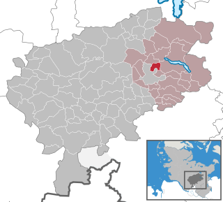
Plön is a district in Schleswig-Holstein, Germany. It is bounded by the districts of Ostholstein and Segeberg, the city of Neumünster, the district of Rendsburg-Eckernförde, the city of Kiel and the Baltic Sea.

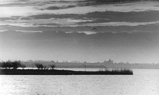
Plön is the district seat of the Plön district in Schleswig-Holstein, Germany, and has about 8,700 inhabitants. It lies right on the shores of Schleswig-Holstein's biggest lake, the Great Plön Lake, as well as on several smaller lakes, touching the town on virtually all sides. The town's landmark is Plön Castle, a chateau built in the 17th century on a hill overlooking the town.
Ostholstein is a district in Schleswig-Holstein, Germany. It is bounded by the districts of Stormarn, Segeberg and Plön, the Baltic Sea and the city of Lübeck. Geographically, the district covers the vast majority of what is considered to be the peninsular of Wagria.

Anglia is a small peninsula in northern Germany, on the Baltic coast of Jutland. Jutland consists of the mainland of Denmark and the northernmost German state of Schleswig-Holstein. Anglia belongs to the region of Southern Schleswig, which constitutes the northern part of Schleswig-Holstein. The region is often referred to in German as Landschaft Angeln or Halbinsel Angeln.

The Trave is a river in Schleswig-Holstein, Germany. It is approximately 124 kilometres (77 mi) long, running from its source near the village of Gießelrade in Ostholstein to Travemünde, where it flows into the Baltic Sea. It passes through Bad Segeberg, Bad Oldesloe, and Lübeck, where it is linked to the Elbe–Lübeck Canal. It is navigable for sea-going vessels from the Baltic to the Lübeck ports. The Herren Tunnel crosses the Trave, as do numerous bridges, and a ferry connects Travemünde with Priwall. Tributaries of the Trave include the Wakenitz and the Stepenitz.

The Treene is a river, hydrologically 95 km (59 mi) and nominally 73.4 km (45.6 mi) long, in Southern Schleswig in the north of Schleswig-Holstein, Germany. It is a right-bank tributary of the River Eider. It starts in northern Angeln, southeast of Flensburg, and flows mainly south-south-west before joining the Eider near Friedrichstadt.

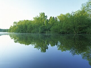
The Großer Plöner See or Lake Plön is the largest lake (30 km2) in Schleswig-Holstein, Germany. It is located near the town of Plön. Its main tributary, as well as its main outflow, is the River Schwentine.
Despite its name, the Dassower See , sometimes called Lake Dassow or Dassow Bay in English, is not a lake, but a side bay, locally known as a wiek, of the Trave Fjord, northeast of Lübeck (Schleswig-Holstein) on the Baltic Sea.
Osterby is a municipality in the district of Rendsburg-Eckernförde, in Schleswig-Holstein, Germany. It is mostly rural.
Klein Rönnau is a municipality in the district of Segeberg, in Schleswig-Holstein, Germany. On an Area of 453 acres (1.83 km2) live about 1600 people. There are three car workshops, several doctors, supermarkets, and numerous clubs for riding, dog training, and the sportsclub in Klein Rönnau. Most of the inhabitants are Protestants or non-religious.

The North German Plain or Northern Lowland is one of the major geographical regions of Germany. It is the German part of the North European Plain. The region is bounded by the coasts of the North Sea and the Baltic Sea to the north, Germany's Central Uplands to the south, by the Netherlands to the west and Poland to the east.
The Schwentine is a river in the North German state of Schleswig-Holstein. It is approximately 62 kilometres (39 mi) long and rises on the hill of Bungsberg, the highest point in the state, near the village of Kasseedorf in Ostholstein. It then runs from its source to Kiel where it flows into the Kiel Fjord, a bay of the Baltic Sea. It passes through several lakes, including the Großer Plöner See, the largest lake in Schleswig-Holstein, as well as the towns Eutin, Malente, Plön, Preetz and Kiel.
Germany is a country in Central and Western Europe that stretches from the Alps, across the North European Plain to the North Sea and the Baltic Sea. It is the second-most populous country in Europe after Russia, and is seventh-largest country by area in the continent. The area of Germany ranked 63rd and covers 357,021 km2 (137,847 sq mi), consisting of 349,223 km2 (134,836 sq mi) of land and 7,798 km2 (3,011 sq mi) of waters, smaller than Japan but larger than Republic of the Congo.

Holstein Switzerland is a hilly area with a patchwork of lakes and forest in Schleswig Holstein, Germany, reminiscent of Swiss landscape. Its highest point is the Bungsberg. It is a designated nature park as well as an important tourist destination in Northern Germany situated between the cities of Kiel and Lübeck.

The Kellersee is a lake in the Holstein Switzerland region of North Germany. It lies east of the village of Malente on the River Schwentine, has an area of 560 hectares, is up to 27 metres deep and lies at a height of 24 m above sea level (NN). Southeast of the lake is the village of Fissau in the borough of Eutin.

Jutland is a peninsula of Northern Europe that forms the continental portion of Denmark and part of northern Germany (Schleswig-Holstein). It stretches from the Grenen spit in the north to the confluence of the Elbe and the Sude in the southeast. The historic southern border river of Jutland as a cultural-geographical region, which historically also included Southern Schleswig, is the Eider. The peninsula, on the other hand, also comprises areas south of the Eider: Holstein, the former duchy of Lauenburg, and most of Hamburg and Lübeck.

The Schleswig-Holstein Uplands or Schleswig-Holstein Morainic Uplands is one of the three landscapes of the German state of Schleswig-Holstein; the others being the marsch and the geest. In addition, the gently rolling hills or Hügelland of the Baltic Uplands, the many small lakes and the long, deep embayments (Förde) formed by the moraines of the Weichselian Ice Age are characteristic features of the area. Its best-known towns are Kiel, Lübeck and Flensburg. The highest elevation in the area is the Bungsberg in the region known as Holstein Switzerland. On the Bungsberg is the only ski lift in the state.
The Kossau is a stream in the district of Plön in eastern Schleswig-Holstein, Germany. It drains the lake Tresdorfer See and flows past Lütjenburg and through the Großer Binnensee before entering the Baltic Sea near Hohwacht. The stream was dammed near Rantzau Castle in the Middle Ages to form a lake which existed until the 18th century. It is about 22 kilometres (14 mi) long and most of its course consists of meanders. It is largely in a natural state and, together with its wet meadows, forms a rich habitat. The Kossau Valley is a designated nature reserve.

The Lauenburg Lakes Nature Park was founded in 1961 and lies in the district of Lauenburg in the southeastern part of the German state of Schleswig-Holstein. It is right on the border with the state of Mecklenburg-Vorpommern in the Schleswig-Holstein Uplands, a Young Drift moraine landscape that formed during the Weichselian glaciation of the last ice age.


