
North Rhine-Westphalia or North-Rhine/Westphalia, commonly shortened to NRW, is a state (Land) in Western Germany. With more than 18 million inhabitants, it is the most populous state in Germany. Apart from the city-states, it is also the most densely populated state in Germany. Covering an area of 34,084 km2 (13,160 sq mi), it is the fourth-largest German state by size.

Horn-Bad Meinberg is a German city in the Lippe district in the north-east of North Rhine-Westphalia on the edge of the Teutoburg forest. The district Bad Meinberg is a spa resort. It has 17,263 inhabitants (2019). It was formed in 1970 by merging various other municipalities that had grown together, including Bad Meinberg and Horn - the new entity's original name was Bad Meinberg-Horn, before taking its present name.

Ahr is a river in Germany, a left tributary of the Rhine. Its source is at an elevation of approximately 470 metres (1,540 ft) above sea level in Blankenheim in the Eifel, in the cellar of a timber-frame house near the castle of Blankenheim. After 18 kilometres (11 mi) it crosses from North Rhine-Westphalia into Rhineland-Palatinate.

The Volme is a river in North Rhine-Westphalia, Germany, and is a tributary of the river Ruhr. It is 50.5 kilometres (31.4 mi) long, of which about 21 km (13 mi) lie within the city limits of Hagen. Its largest tributary is the Ennepe.

The Egge Hills, or just the Egge is a range of forested hills, up to 464 m above sea level (NN), in the east of the German state of North Rhine-Westphalia.

The Arnsberg Forest Nature Park is a nature park in the districts of Hochsauerlandkreis and Soest within the administrative region of Arnsberg in the German state of North Rhine-Westphalia. The park was established in 1960 and covers an area of 482 km2. Nearly 350 km2 of the protection is forested and the park's wooded hills rise up to 581.5 m above sea level (NN).

The Langenberg rises on the state border between North Rhine-Westphalia and Hesse in Germany and, at 843.2 m above sea level (NN), is the highest peak in the Rothaar mountain range, as well as the highest point in the North Rhine-Westphalia and also in the north of Germany outside the Harz Mountains.
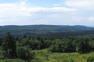
At 446.4 m above sea level (NN) the Barnacken is the highest hill in the Teutoburg Forest in the German state of North Rhine-Westphalia.

The Klosterbach is a right-hand tributary of the Große Aue, which is known as the Neuer Mühlenbach at the point where they join, in north Germany. The Klosterbach lies entirely within the parish of Rödinghausen in the district of Herford, North Rhine-Westphalia.

The Stemweder Berg is a ridge 181.4 metres (595 ft) above sea level on the border of North Rhine-Westphalia and Lower Saxony in Germany. It is the northernmost and smallest of Germany's Central Uplands ranges.

Emmer is a river of Lower Saxony and North Rhine-Westphalia, Germany. It flows into the Weser in Emmerthal.

The Armuthsbach is an 18.4-kilometre-long, orographically left-hand tributary of the Ahr in the German states of North Rhine-Westphalia and Rhineland-Palatinate.

Harlebach is a river of North Rhine-Westphalia, Germany. It is a 7.6-kilometre-long (4.7 mi) tributary of the river Alme in North Rhine-Westphalia, Germany. The Harlebach rises at 430 m (1,410 ft) above sea level in the Arnsberg forest, above Brilon. It joins the Alme through forested areas including the Almetal nature reserve. It acts as the boundary between Paderborn and Hochsauerlandkreis.

Heubach is a river of North Rhine-Westphalia, Germany. It flows into the Emmer in Steinheim.
Kleine Aa is a river of North Rhine-Westphalia, Germany, a tributary of the Aabach. Thus it is part of the Rhine River Basin.
Strombach is a river of North Rhine-Westphalia, Germany. It is a right tributary of the Agger.
The Weiß is a river of North Rhine-Westphalia, Germany, which is 18.1 kilometers (11.2 mi) in length. Its source is near the mountain Kalteiche, at a height of 493 meters (1,617 ft) above sea level. Then it flows through the villages Wilgersdorf, Rudersdorf, Anzhausen, Niederdielfen, Kaan-Marienborn, and the city Siegen. The Weiß flows into the Sieg in Siegen, at 247 meters elevation.
Wenne is a river of North Rhine-Westphalia, Germany. The river springs in a forest area near Obringhausen.
The Wiehl is a 33.6-kilometre-long, orographically left tributary of the River Agger in the German state of North Rhine-Westphalia. It is the longest river situated entirely within the county of Oberbergischer Kreis and the third longest tributary of the Agger.

The Aubach is an orographically left tributary of the River Wiehl in the German state of North Rhine-Westphalia.

