The Brahmaputra is a trans-boundary river which flows through Southwestern China, Northeastern India, and Bangladesh. It is known as Brahmaputra or Luit in Assamese, Yarlung Tsangpo in Tibetan, the Siang/Dihang River in Arunachali, and Jamuna River in Bengali. By itself, it is the 9th largest river in the world by discharge, and the 15th longest.
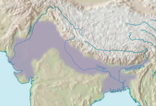
The Indo-Gangetic Plain, also known as the North Indian River Plain, is a 700-thousand km2 (172-million-acre) fertile plain encompassing northern regions of the Indian subcontinent, including most of modern-day northern and eastern India, most of eastern-Pakistan, virtually all of Bangladesh and southern plains of Nepal. Also known as the Indus–Ganga Plain, the region is named after the Indus and the Ganges rivers and encompasses a number of large urban areas. The plain is bounded on the north by the Himalayas, which feed its numerous rivers and are the source of the fertile alluvium deposited across the region by the two river systems. The southern edge of the plain is marked by the Deccan Plateau. On the west rises the Iranian Plateau. Many developed cities like Delhi, Dhaka, Kolkata, Lahore, Islamabad and Karachi are located in the Indo-Gangetic Plain.
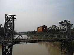
Kolia Bhomora Setu, an existing bridge completed in 1987, is a 3.015 km long pre-stressed concrete road bridge on NH-715 over the Brahmaputra River in Tezpur Assam state of India, which connects Tezpur in Sonitpur district on northern bank with Kaliabor in Nagaon District on the south bank. It is named after the Ahom General Kolia Bhomora Phukan. A new Bhomoraguri-Tezpur Bridge 3.040 km long, few meters parallel to the existing Kolia Bhomora Setu, is opened in 2021.
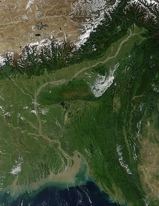
The Brahmaputra Valley is a region situated between hill ranges of the eastern and northeastern Himalayan range in Eastern India.
Buragohain was the one of the two original counsellors in the Ahom kingdom. He was selected by the Ahom king from members of the Ahom nobility ,who vowed not to fight for the position of Ahom kingship, rather act as a guide to the Ahom king in matters of administering his province in an efficient manner. The other original counsellor is Chao Thao Lung or Borgohain. Both the positions existed from the time of the first Ahom king, Sukaphaa.

The Dhansiri is a river of Golaghat District of Assam and the Chümoukedima District and Dimapur District of Nagaland. It originates from Laisang peak of Nagaland. It flows through a distance of 352 kilometres (219 mi) from south to north before joining the Brahmaputra on its south bank. Its total catchment area is 1,220 square kilometres (470 sq mi).
The Ministry of Water Resources, River Development and Ganga Rejuvenation was the apex body for formulation and administration of rules and regulations relating to the development and regulation of the water resources in India. The Ministry was formed in January 1985 following the bifurcation of the then Ministry of Irrigation and Power, when the Department of Irrigation was re-constituted as the Ministry of Water Resources. In July 2014, the Ministry was renamed to “Ministry of Water Resources, River Development & Ganga Rejuvenation”, making it the National Ganga River Basin Authority for conservation, development, management, and abatement of pollution in the river Ganges and its tributaries. In May 2019, this ministry was merged with the Ministry of Drinking Water and Sanitation to form the Ministry of Jal Shakti.
The Kolong River or Kailang is an anabranch of the Brahmaputra River, which diverts out from the Brahamputra river in Hatimura region of Jakhalabandha, and meets the same at Kolongpar near Guwahati. The tributary is about 250 kilometres (160 mi) long and flows through the districts of Nagaon, Morigaon and Kamrup. On the way, several smaller streams meet it. The river flows through the heart of the Nagaon urban area, dividing the town into Nagaon and Haiborgaon.
The Mornoi River is a tributary of the Brahmaputra River in the Indian state of Assam. The Mornoi river originates at Matia village of Goalpara district. The Krishnai River meets Dudhnoi River at Matia village and then flows as Mornoi river before its confluence with the Brahmaputra River.
The Brahmaputra floods refers to a catastrophic flood event that occurred in 2012 along the Brahmaputra River and its tributaries, as well as in subsequent years.
The Gabharu River is a northern bank tributary of the Brahmaputra River in the Indian state of Assam. The Gabharu River originates in the Kalafangapo hills of Arunachal Pradesh in the West Kameng District and flows through Sonitpur district of Assam before its confluence with the Brahmaputra River at Gadharu Mukh of Sonitpur district. The Gabharu River consists of two right bank subtributaries known as Sonairupai River and Gelgeli River and Mora Depota River is the left bank sub tributary.

The Champabati River is a tributary of the Brahmaputra River in the Indian state of Assam. The Champabati River has three sub tributaries - Bhur River, Lopani and Dhol pani which are originated from Bhutan hills.

The Dikrong River is a sub-tributary of the Brahmaputra River in the Indian state of Assam. The Dikrong river originates in the hills of Arunachal Pradesh and flows through major cities like Nirjuli in Arunachal Pradesh and Bihpuria in Assam before its confluence with the Subansiri River.
The Nona River is a sub-tributary of the Brahmaputra River in the Indian state of Assam. The Nona River originates in the hills of Samdrup Jongkhar and flows through Baksa district and Nalbari district in Assam before its confluence with the Baralia River.
The Bharalu River is a tributary of the Brahmaputra River in the Indian state of Assam. The Bharalu River originates in the Khasi Hills of Meghalaya and flows through the heart of Guwahati before its confluence with the Brahmaputra River. Bharalu river is one of the most polluted rivers in the state of Assam.

The Dudhnoi River is a sub-tributary of the Brahmaputra River in the Indian state of Assam. The Dudhnoi River originates in the East Garo Hills of Meghalaya. The Dudhnoi River meets Krishnai River at Matia of Goalpara district and then flows as Mornoi River before its confluence with the Brahmaputra River. Floods in Goalpara district is dictated by the Dudhnoi river.
The Krishnai River is a sub-tributary of the Brahmaputra River in the Indian state of Assam. The Krishnai River originates in the West Garo Hills of Meghalaya. The Krishnai River meets Dudhnoi River at Matia of Goalpara district and then flows as Mornoi River before its confluence with the Brahmaputra River.

The Tipkai River is a north and Himalayan tributary of the Brahmaputra River in the Indian state of Assam. It rises in the Bhutan hills, flows through the Kokrajhar district and Dhubri district of Assam and joins the Brahmaputra River at Chatakurachar of Dhubri district.
The Diju River is a sub- tributary of the Brahmaputra River in the Indian state of Assam.