Dilworth, Oklahoma

Last updated

Dilworth was one of the many oil boomtowns created in Kay County, Oklahoma during the early part of the 20th Century. [1] It was located about 10.5 miles northwest of Newkirk, the county seat, or about 14 miles by present-day roads. [2] [3] While it is now designated a Populated Place, it is considered a ghost town. [2] [1] [4]

History

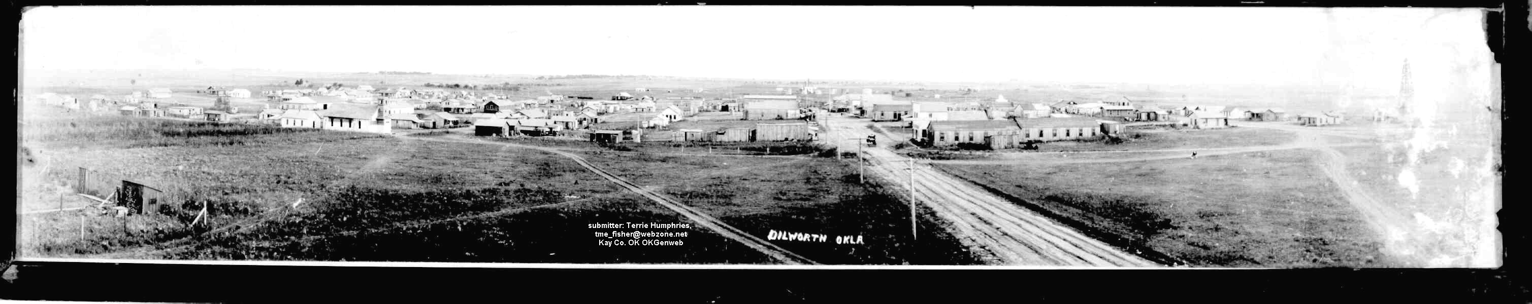
Dilworth was founded about November 1916, in a booming oil field variously known as the Blackwell field or the Dilworth field. [5] [6] [7] In that same year, the Oil Fields Short Line Railroad was completed into Dilworth from a connection point called Clifford off the St. Louis-San Francisco Railway. [8] 1916 also saw Dilworth get its own weekly newspaper, the Dilworth New Era, which on its masthead called Dilworth “The City of the Flowing Gold,” and placed the town “in the Heart of the Oil Fields.” [9] [10] A Post Office opened in April 1917. [11] A vote to incorporate as the Town of Dilworth passed in late October 1917, and the first town ordinances were promulgated in March 1918. [12] [13] The population of Dilworth climbed to several thousand. [14] At one time it had a grain elevator, 4 or 5 business houses, 2 stores, a lumber yard, a Doctor's office, and a garage. [15] A panorama photograph of Dilworth circa 1925 shows a substantial little town had been constructed. [16]

However, the boom was short lived. By the end of 1923, the population was down to about 50, and the Oil Fields Short Line Railroad, by then losing money, abandoned the route into Dilworth. [15] In March 1929, the Newkirk Herald-Journal reported Dilworth was on the verge of losing its Post Office, and that the town which was once the “oil capitol of the county” had dropped into the class of Kay County's ghost oil towns. [14]

Related Research Articles

<span class="mw-page-title-main">Washington County, Oklahoma</span> County in Oklahoma, United States

Washington County is a county located in the northeastern part of the U.S. state of Oklahoma. As of the 2020 census, the population was 52,455. Its county seat is Bartlesville. Named for President George Washington, it is the smallest county in Oklahoma in total area, adjacent to the largest county in Oklahoma, Osage County.

<span class="mw-page-title-main">Kay County, Oklahoma</span> County in Oklahoma, United States

Kay County is a county located in the U.S. state of Oklahoma. As of the 2020 census, its population was 43,700. Its county seat is Newkirk, and the largest city is Ponca City.

<span class="mw-page-title-main">Grant County, Oklahoma</span> County in Oklahoma, United States

Grant County is a county located on the northern border of the U.S. state of Oklahoma. As of the 2020 census, the population was 4,169. Its county seat is Medford. Originally designated as part of the Cherokee Outlet, it was named County L in Oklahoma Territory at the time of its opening to non-Indian settlement. A county election renamed it for U.S. President Ulysses S. Grant.

<span class="mw-page-title-main">Dilworth, Minnesota</span> City in Minnesota, United States

Dilworth is a city in Clay County, Minnesota, United States. The population was 4,612 at the time of the 2020 census. Dilworth is one of the core cities of the Fargo–Moorhead metro area; it is on the eastern border of Moorhead. Dilworth is home to the historic Star Lite Motel and the Dilworth Rail Yard, one of the BNSF Railway's largest and busiest facilities in Minnesota.

<span class="mw-page-title-main">Cherokee, Oklahoma</span> City in Oklahoma, United States

Cherokee is the largest city within, and county seat of, Alfalfa County, Oklahoma, United States. The population was 1,476 at the 2020 census, a decline of 1.5 percent from 2010.

<span class="mw-page-title-main">Sayre, Oklahoma</span> City in Oklahoma, United States

Sayre is a city in, and the county seat of, Beckham County, in western Oklahoma, United States. It is halfway between Oklahoma City and Amarillo, Texas on Interstate 40 and the former U.S. Route 66. The population was 4,809 at the time of the 2020 census, an increase over the 4,375 figure from the 2010 census, and the largest population ever recorded by a census since Sayre's founding.

<span class="mw-page-title-main">Wilson, Oklahoma</span> Town in Oklahoma, United States

Wilson is a town in Carter County, Oklahoma, United States. The population was 1,724 at the 2010 census. It is part of the Ardmore, Oklahoma Micropolitan Statistical Area. It is home to one of the oldest Assemblies of God churches in Oklahoma, the Wilson Assembly of God Church.

<span class="mw-page-title-main">Shamrock, Oklahoma</span> Town in Oklahoma, United States

Shamrock is an unincorporated community in Creek County, Oklahoma, United States, located on Oklahoma State Highway 16 south of Drumright and west-northwest of Bristow. The population was 65 at the time of the 2020 census. It was named for Shamrock, Illinois, the hometown of local store owner, James M. Thomas.

<span class="mw-page-title-main">Yeager, Oklahoma</span> Town in Oklahoma, United States

Yeager is a town in Hughes County, Oklahoma, United States. The population was 75 at the 2010 census. Developed in the early 1900s, the town grew with the help of an oil and gas field, but has always had a low population.

<span class="mw-page-title-main">Kaw City, Oklahoma</span> City in Oklahoma, United States

Kaw City is a city in eastern Kay County, Oklahoma, United States. The population was 325 as of the 2020 United States census. Kaw City was named for the Kanza Indians, called the Kaw by locals.

<span class="mw-page-title-main">Newkirk, Oklahoma</span> City in Oklahoma, United States

Newkirk is a city and county seat of Kay County, Oklahoma, United States. The population was 2,172 at the 2020 census.

<span class="mw-page-title-main">Drumright, Oklahoma</span> City in Oklahoma, United States

Drumright is a city in Creek and Payne counties in the U.S. state of Oklahoma. It began as an oil boom town. However, the population has declined as oil production has waned in the area. The population was 2,907 at the 2010 census, a figure almost unchanged from 2,905 in 2000. Drumright and nearby Cushing were at the center of the large, productive Cushing-Drumright Oil Field in the 1910s and 1920s. Now Drumright is home to a festival called The Drumright Monthly Market, where hundreds of visitors come on the first Saturday of every month, seeking crafts and delicacies from all over the region.

<span class="mw-page-title-main">St. Louis–San Francisco Railway</span> Former American railroad

The St. Louis–San Francisco Railway, commonly known as the "Frisco", was a railroad that operated in the Midwest and South Central United States from 1876 to November 21, 1980. At the end of 1970, it operated 4,547 miles (7,318 km) of road on 6,574 miles (10,580 km) of track, not including subsidiaries Quanah, Acme and Pacific Railway and the Alabama, Tennessee and Northern Railroad; that year, it reported 12,795 million ton-miles of revenue freight and no passengers. In 1980 it was purchased by and absorbed into the Burlington Northern Railroad. Despite its name, it never came close to San Francisco.

<span class="mw-page-title-main">Green Corn Rebellion</span>

The Green Corn Rebellion was an armed uprising that took place in rural Oklahoma on August 2 and 3, 1917. The uprising was a reaction by European-Americans, tenant farmers, Seminoles, Muscogee Creeks, and African-Americans to an attempt to enforce the Selective Draft Act of 1917. The name "Green Corn Rebellion" was a reference to the purported plans of the rebels to march across the country and to eat "green corn" on the way for sustenance. They hoped to be joined by thousands of sympathizers, march to Washington, D.C., overthrow the federal government, abolish the draft, and end U.S. involvement in the war. Many of the rebels were aligned with the Socialist Party of America.

<span class="mw-page-title-main">John G. McCaskey</span>

John Gruard McCaskey was an American oil businessman.

Douthat is a ghost town in Ottawa County, Oklahoma, United States. Douthat is 2 miles (3.2 km) south of Picher. Douthat once had a post office, which opened on March 17, 1917. The community was named after Zahn A. Douthat, the owner of the townsite. Douthat is now abandoned and part of the Tar Creek Superfund site.

The Sapulpa and Oil Field Railroad (S&OF) was a shortline railway which was constructed by 1915 or 1916 from the oil boomtown of Depew, Oklahoma to the newer boomtown of Shamrock, Oklahoma, about 9 miles. Despite the name, the line never came close to the city of Sapulpa, Oklahoma, which was far to the northeast.

The Oil Fields Short Line Railroad had both a short route—about 4.4 miles between Clifford and Dilworth in Kay County, Oklahoma—and a short existence, being created in 1916 and abandoned at the end of 1923.

The Oklahoma, New Mexico and Pacific Railway, known colloquially as the “Ringling Railroad,” ran from Ardmore, Oklahoma to Ringling, Oklahoma, with a branch to Healdton, Oklahoma. It was started in 1913, and was sold to an Atchison, Topeka and Santa Fe Railway (AT&SF) affiliate in 1926.

The Webbers Falls Railroad (W.F.R.R.) was a shortline railway operating between the towns of Webbers Falls and Warner in the State of Oklahoma. Its predecessor began operations in 1911, and its line was dismantled by 1918.

References

  1. 1 2 "Kay County". Oklahoma Historical Society. Archived from the original on November 11, 2020. Retrieved August 1, 2022.
  2. 1 2 "Dilworth (in Kay County, OK) Populated Place Profile". HomeTownLocator. Archived from the original on August 12, 2014. Retrieved August 1, 2022.
  3. "Newkirk, Oklahoma to Dilworth, Oklahoma". Google Maps. Archived from the original on August 2, 2022. Retrieved August 1, 2022.
  4. "Kay County Genealogy Resources". Travel Oklahoma. Archived from the original on January 10, 2022. Retrieved August 1, 2022.
  5. "New Oil Town Ready". Drumright Evening Derrick, November 2, 1916 (accessed on Oklahoma Historical Society). November 2, 1916. Archived from the original on August 2, 2022. Retrieved August 2, 2022.
  6. "The Dilworth Oil and Gas Field". Dilworth New Era, May 24, 1917. May 24, 1917. Archived from the original on August 2, 2022. Retrieved August 1, 2022.
  7. "Dilworth, The City of the Flowing Gold—Best Advertised Town in Oklahoma". Dilworth New Era, November 8, 1917. Archived from the original on August 2, 2022. Retrieved August 1, 2022.
  8. "Oil Fields Short Line Railroad Company". Railroads of Oklahoma, June 6, 1870-April 1, 1978, p. 57 (accessed of Oklahoma Digital Prairie). Archived from the original on May 16, 2021. Retrieved July 26, 2022.
  9. "Dilworth New Era, Volume 1, No. 34, August 2, 1917". Oklahoma Historical Society. August 2, 1917. Archived from the original on August 2, 2022. Retrieved August 1, 2022.
  10. "Dilworth New Era (Dilworth, Kay County, Okla.) 1916-19??". Library of Congress. Archived from the original on August 2, 2022. Retrieved August 1, 2022.
  11. "Rural Route No. 1". Dilworth New Era, April 11, 1918. April 11, 1918. Archived from the original on August 2, 2022. Retrieved August 1, 2022.
  12. "Not a Vote Against It". Dilworth New Era, October 25, 1917. October 25, 1917. Archived from the original on August 2, 2022. Retrieved August 1, 2022.
  13. "Ordinance No. 1, Ordinance No. 2". Dilworth New Era, March 28, 1918. March 28, 1918. Archived from the original on August 2, 2022. Retrieved August 1, 2022.
  14. 1 2 "Town Vanishing". The Newkirk Herald Journal, March 14, 1929. March 14, 1929. Archived from the original on August 2, 2022. Retrieved August 2, 2022.
  15. 1 2 "In the matter of the Application of the Oil Fields Short Line Railroad for permission to abandon and cease operating its line of railroad in Kay County, Oklahoma". 1924. Archived from the original on August 2, 2022. Retrieved August 1, 2022.
  16. "Dilworth, circa 1925". OKGenWeb. Retrieved August 1, 2022.

36°56′29″N97°13′41″W / 36.94139°N 97.22806°W / 36.94139; -97.22806