
The Rhine is one of the major European rivers. The river begins in the Swiss canton of Graubünden in the southeastern Swiss Alps. It forms part of the Swiss-Liechtenstein border, then part of the Swiss-Austrian border. From Lake Constance downstream, it forms part of the Swiss-German border. After that the Rhine defines much of the Franco-German border. It then flows in a mostly northerly direction through the German Rhineland. Finally in Germany, the Rhine turns into a predominantly westerly direction and flows into the Netherlands where it eventually empties into the North Sea. It drains an area of 9,973 km2.

The Aller is a 215-kilometre-long (134 mi) river in the states of Saxony-Anhalt and Lower Saxony in Germany. It is a right-hand, and hence eastern, tributary of the Weser and is also its largest tributary. Its last 117 kilometres (73 mi) form the Lower Aller federal waterway. The Aller was extensively straightened, widened and, in places, dyked during the 1960s to provide flood control of the river. In a 20-kilometre-long (12 mi) section near Gifhorn, the river meanders in its natural river bed.
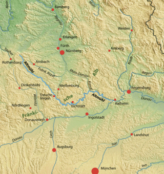
The Altmühl is a river in Bavaria, Germany. It is a left tributary of the river Danube and is approximately 230 kilometres (140 mi) long.

The Tarim River, known in Sanskrit as the Śītā, is an endorheic river in Xinjiang, China. It is the principal river of the Tarim Basin, a desert region of Central Asia between the Tian Shan and Kunlun Mountains. The river historically terminated at Lop Nur, but today reaches no further than Taitema Lake before drying out.

The Dommel is a small river in Belgium and the Netherlands, left tributary of the Dieze. It is 120 km long, of which 85 km are in the Netherlands. The Dommel takes in water from the Keersop, Tongelreep, Run, Gender and Kleine Dommel streams and merges at 's-Hertogenbosch with the Aa stream to form the river Dieze, which subsequently flows towards the Meuse. The main cities and towns along the Dommel's course are Peer, Neerpelt, Valkenswaard, Dommelen, Eindhoven, Son en Breugel, Sint-Oedenrode, Boxtel, Sint-Michielsgestel and 's-Hertogenbosch.

The Hamme is a 48 km (30 mi) long river in Germany, Lower Saxony, north-east of Bremen. Its source is north of Osterholz-Scharmbeck. It flows through the moors north-east of Bremen called Teufelsmoor, and meets the river Wümme in Ritterhude. From this junction, the river is called Lesum. The Lesum flows into the river Weser in Bremen-Vegesack.

The Brahmani is a major seasonal river in the Odisha state of eastern India. The Brahmani is formed by the confluence of the Sankh and South Koel rivers, and flows through the districts of Sundargarh, Deogarh, Angul, Dhenkanal, Cuttack, Jajapur and Kendrapara. Also the South Koel can be considered as the upper reaches of the Brahmani. Together with the river Baitarani, Brahmani forms a large delta before emptying into the Bay of Bengal at Dhamra. It is the second widest river in Odisha after Mahanadi.

The Amper, called the Ammer upstream of the Ammersee, through which it runs, is the largest tributary of the Isar in southern Bavaria, Germany. It flows generally north-eastward, reaching the Isar in Moosburg, about 185 kilometres (115 mi) from its source in the Ammergau Alps, with a flow of 45 m³/s. Including its tributary, Linder, it is 209.5 km (130.2 mi) long. Major tributaries are the Glonn, which rises near Augsburg; the Würm, which is the outflow of Lake Starnberg; and the Maisach.
Markala is a commune in Mali's Ségou Region on the Niger River 35 km down stream from the town of Ségou. The commune contains 30 villages in an area of 318 square kilometers and in 2009 had a population of 45,961. Mali's primary irrigation dam, the Markala dam, lies in the commune. The main village of the commune, Diamarabougou, is on the right bank adjacent to the dam which also serves as an important road bridge.

The Murr is a river in Baden-Württemberg, Germany. It is a right tributary of the Neckar. The river gave its name to a small town on its banks, Murr, and to the Rems-Murr-Kreis district, which was also named after the river Rems, which runs roughly parallel to the south of the Murr.

The Selz is a river in Rhineland-Palatinate, Germany, and a left hand tributary of the Rhine. It flows through the largest German wine region, Rheinhessen.

Djedi River, also called Djeddi River, Oued Djedi or Ouad-ed-Djedi is a wadi in Algeria and one of the largest rivers of Sahara. It starts in the Saharan Atlas mountains, at elevation of about 1,400 meters (4,600 ft), flows for about 480 kilometers (300 mi) approximately from west to east, and discharges into Chott Melrhir lake at about –40 meters (130 ft) below mean sea level, which is the lowest point of Algeria. It is fed by rains and melting snow and has a permanent flow only in its upper part. The river rises on the southern slopes of Djebel Amour, near the town of Aflou, and feeds several date palm groves, such as the Laghouat oasis, which largely depend on this supply; water is also taken from numerous wells dug near the river. During the rain season in winter, the river helps to rise the water level of Chott Melrhir, and in summer, the lake and lower reaches of the river dry out. The river is up to several kilometers wide, but its banks are rarely covered with water. The river bed mostly consists of gypsum and mud and bears traces of erosion associated with the large variations of the flow. Although the soil in and around the river appears arable, it is barren due to the high concentration of salt. For the same reason, the soil absorbs much condensation overnight that keeps it partly humid during much of the day.

The Wutach is a river, 91 kilometres long, in the southeastern part of the Black Forest in the German state of Baden-Württemberg. It is a right-hand tributary of the Rhine. In its lower reaches it flows for about 6 kilometres along the border with the canton of Schaffhausen, Switzerland.

The Queich is a tributary of the Rhine, which rises in the southern part of the Palatinate Forest, and flows through the Upper Rhine valley to its confluence with the Rhine in Germersheim. It is 52 kilometres (32 mi) long and is one of the four major drainage systems of the Palatinate Forest along with the Speyerbach, Lauter and Schwarzbach. The Queich flows through the towns Hauenstein, Annweiler am Trifels, Siebeldingen, Landau, Offenbach an der Queich and Germersheim.
The Steinlach is a river with a length of 26 km (16 mi) in Baden-Württemberg, Germany. It is a tributary to the Neckar.

The Upper Anaicut, also known as Mukkombu is a dam built on the Kaveri River in the state of Tamil Nadu in southern India. The regulator dam was constructed between 1836 and 1838 by Sir Arthur Cotton, a British irrigation engineer who was inspired by the architectural beauty of Grand Anaicut canal built by Karikala Chola in Kallanai of Thanjavur district in the second century.
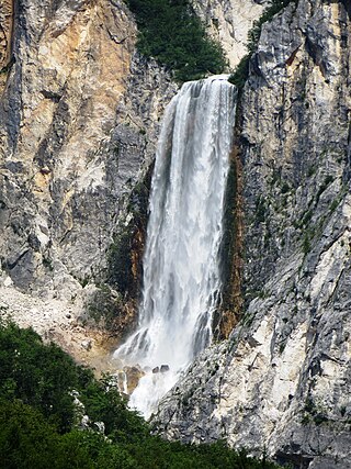
Boka is a waterfall in the western part of Slovenia, near the Soča River. It begins at a karst spring and has two stages, of which the first is 106 meters (348 ft) high and 18 meters (59 ft) wide, and the second is 33 meters (108 ft) high.

The Oued Meraldene or Oued Merabtene, also called Oued Bourdine, is a river of Algeria located in Kabylia within the framework of the Province of Boumerdès.

The Krassach is a left tributary of the Weismain about 7 kilometers long, which flows into the Main near Altenkunstadt in Upper Franconia.
