
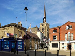
Wymondham is a market town and civil parish in the South Norfolk district of Norfolk, England, 12 miles (19 km) south-west of Norwich off the A11 road to London. The River Tiffey runs through. The parish, one of Norfolk's largest, includes rural areas to the north and south, with hamlets of Suton, Silfield, Spooner Row and Wattlefield. It had a population of 14,405 in 2011, of whom 13,587 lived in the town itself.

Holt is a market town, civil parish and electoral ward in the English county of Norfolk. The town is 22.8 miles (36.7 km) north of the city of Norwich, 9.5 miles (15.3 km) west of Cromer and 35 miles (56 km) east of King's Lynn. The town has a population of 3,550, rising and including the ward to 3,810 at the 2011 census. Holt is within the area covered by North Norfolk District Council. Holt has a heritage railway station; it is the south-western terminus of the preserved North Norfolk Railway, known as the Poppy Line.

Thetford is a market town and civil parish in the Breckland District of Norfolk, England. It is on the A11 road between Norwich and London, just east of Thetford Forest. The civil parish, covering an area of 29.55 km2 (11.41 sq mi), in 2011 had a population of 24,340.
South Norfolk is a local government district in Norfolk, England. The largest town is Wymondham, and the district also includes the towns of Costessey, Diss, Harleston, Hingham, Loddon and Long Stratton. The council was based in Long Stratton until 2023 when it moved to the Broadland Business Park near Norwich, in the neighbouring Broadland district, as part of a shared facility with Broadland District Council. Some of the district's urban areas form part of the Norwich built-up area. The district also includes numerous villages and surrounding rural areas. Some eastern parts of the district lie within The Broads.
Mid Suffolk is a local government district in Suffolk, England. The district is primarily a rural area, containing just three towns, being Stowmarket, Needham Market and Eye. Its council was based in Needham Market until 2017 when it moved to shared offices with neighbouring Babergh District Council in Ipswich, outside either district. In 2021 it had a population of 103,417.

Mole Valley is a local government district in Surrey, England. Its council is based in Dorking, and the district's other town is Leatherhead. The largest villages are Ashtead, Fetcham and Great Bookham, in the northern third of the district.

Diss is a market town and electoral ward in South Norfolk, England, near the boundary with Suffolk, with a population of 7,572 in 2011. Diss railway station is on the Great Eastern Main Line between London and Norwich. It lies in the valley of the River Waveney, round a mere covering 6 acres (2.4 ha) and up to 18 feet (5.5 m) deep, although there is another 51 feet (16 m) of mud.

Downham Market, sometimes simply referred to as Downham, is a market town and civil parish in Norfolk, England. It lies on the edge of the Fens, on the River Great Ouse, approximately 11 miles south of King's Lynn, 39 miles west of Norwich and 30 miles north of Cambridge.

New Alresford or simply Alresford is a market town and civil parish in the City of Winchester district of Hampshire, England. It is 8.0 miles (12.9 km) northeast of Winchester and 12 miles (20 km) southwest of the town of Alton.

Castle Combe is a village and civil parish within the Cotswolds Area of Outstanding Natural Beauty in Wiltshire, England. The village is around 5 miles (8 km) north-west of Chippenham. A castle once stood in the area, but was demolished centuries ago.
Wiveliscombe is a town and civil parish in Somerset, England, situated 9 miles (14 km) west of Taunton. The town has a population of 2,893. The Square, fronted by several listed structures, held the former market. The parish includes the nearby hamlet of Maundown.

New Buckenham is a village and civil parish in the English county of Norfolk.

Stoke Bishop is a medium-sized outer city suburb in the north-west of Bristol. Bordered by The Downs and the River Trym, it is located between Westbury-on-Trym, Sneyd Park and Sea Mills. Although relatively low, Stoke Bishop's population has significantly increased in recent years due to the infilling of former school and company playing fields. Moreover, the population of Stoke Bishop varies throughout the year because of the influx of students during term time to the large campus of Bristol University halls of residence situated on the edge of The Downs.

Brandon is a town and civil parish in the English county of Suffolk. Brandon is located in the Breckland area of Suffolk in the extreme north-west of the county, close to the adjoining county of Norfolk. It lies between the towns of Bury St Edmunds, Thetford, Mildenhall, Downham Market and the city of Ely. The town is almost entirely surrounded by Thetford Forest.

Hilgay is a village and civil parish in Norfolk, England, 4 miles (6 km) south of Downham Market. The parish covers an area of 33.38 km2 (12.89 sq mi) and had a population of 1,341 at the 2011 Census. For local government purposes, it falls within the district of King's Lynn and West Norfolk.

Camden Town Hall, known as St Pancras Town Hall until 1965, is the meeting place of Camden London Borough Council. The main entrance is in Judd Street with its northern elevation extending along Euston Road, opposite the main front of St Pancras railway station. It was completed in 1937 and has been Grade II listed since 1996.

Norfolk County Council is the top-tier local government authority for Norfolk, England. Its headquarters are in the city of Norwich.
Harleston is a town in the civil parish of Redenhall with Harleston, in the South Norfolk district, in the county of Norfolk, England. It is 16 miles (26 km) from Norwich. In 2018, it had an estimated population of 5,067. Harleston is on the Norfolk/Suffolk border, close to the River Waveney. Harleston has 2 markets every Wednesday.

The Old Town Hall is a municipal building in The High Street in Steyning, West Sussex, England. The building, which was used as a courthouse and a public events venue, is a Grade II listed building.

Wymondham Town Hall is a municipal building in Middleton Street in Wymondham, a town in Norfolk, in England. The building, which is currently vacant and is being actively marketed for sale, is a Grade II listed building.
