
Parallax is a displacement or difference in the apparent position of an object viewed along two different lines of sight and is measured by the angle or half-angle of inclination between those two lines. Due to foreshortening, nearby objects show a larger parallax than farther objects, so parallax can be used to determine distances.

Star clusters are large groups of stars held together by self-gravitation. Two main types of star clusters can be distinguished: globular clusters are tight groups of ten thousand to millions of old stars which are gravitationally bound, while open clusters are more loosely clustered groups of stars, generally containing fewer than a few hundred members, and are often very young. Open clusters become disrupted over time by the gravitational influence of giant molecular clouds as they move through the galaxy, but cluster members will continue to move in broadly the same direction through space even though they are no longer gravitationally bound; they are then known as a stellar association, sometimes also referred to as a moving group.
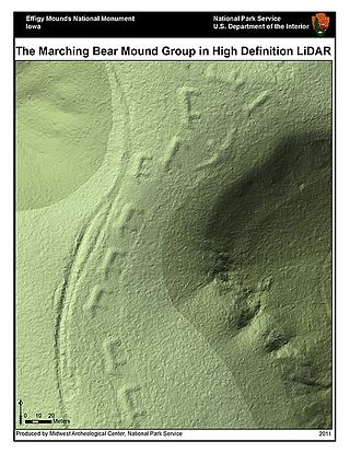
Lidar is a method for determining ranges by targeting an object or a surface with a laser and measuring the time for the reflected light to return to the receiver. Lidar may operate in a fixed direction or it may scan multiple directions, in which case it is known as lidar scanning or 3D laser scanning, a special combination of 3-D scanning and laser scanning. Lidar has terrestrial, airborne, and mobile applications.

Parallax scrolling is a technique in computer graphics where background images move past the camera more slowly than foreground images, creating an illusion of depth in a 2D scene of distance. The technique grew out of the multiplane camera technique used in traditional animation since the 1930s.

Lightning is a natural phenomenon formed by electrostatic discharges through the atmosphere between two electrically charged regions, either both in the atmosphere or one in the atmosphere and one on the ground, temporarily neutralizing these in a near-instantaneous release of an average of between 200 megajoules and 7 gigajoules of energy, depending on the type. This discharge may produce a wide range of electromagnetic radiation, from heat created by the rapid movement of electrons, to brilliant flashes of visible light in the form of black-body radiation. Lightning causes thunder, a sound from the shock wave which develops as gases in the vicinity of the discharge experience a sudden increase in pressure. Lightning occurs commonly during thunderstorms as well as other types of energetic weather systems, but volcanic lightning can also occur during volcanic eruptions. Lightning is an atmospheric electrical phenomenon and contributes to the global atmospheric electrical circuit.

A point cloud is a discrete set of data points in space. The points may represent a 3D shape or object. Each point position has its set of Cartesian coordinates. Point clouds are generally produced by 3D scanners or by photogrammetry software, which measure many points on the external surfaces of objects around them. As the output of 3D scanning processes, point clouds are used for many purposes, including to create 3D computer-aided design (CAD) or geographic information systems (GIS) models for manufactured parts, for metrology and quality inspection, and for a multitude of visualizing, animating, rendering, and mass customization applications.

Nonlinear dimensionality reduction, also known as manifold learning, refers to various related techniques that aim to project high-dimensional data onto lower-dimensional latent manifolds, with the goal of either visualizing the data in the low-dimensional space, or learning the mapping itself. The techniques described below can be understood as generalizations of linear decomposition methods used for dimensionality reduction, such as singular value decomposition and principal component analysis.

A mesh network is a local area network topology in which the infrastructure nodes connect directly, dynamically and non-hierarchically to as many other nodes as possible and cooperate with one another to efficiently route data to and from clients.
In statistics and related fields, a similarity measure or similarity function or similarity metric is a real-valued function that quantifies the similarity between two objects. Although no single definition of a similarity exists, usually such measures are in some sense the inverse of distance metrics: they take on large values for similar objects and either zero or a negative value for very dissimilar objects. Though, in more broad terms, a similarity function may also satisfy metric axioms.
Beamforming or spatial filtering is a signal processing technique used in sensor arrays for directional signal transmission or reception. This is achieved by combining elements in an antenna array in such a way that signals at particular angles experience constructive interference while others experience destructive interference. Beamforming can be used at both the transmitting and receiving ends in order to achieve spatial selectivity. The improvement compared with omnidirectional reception/transmission is known as the directivity of the array.
Video production is the process of producing video content for video. It is the equivalent of filmmaking, but with video recorded either as analog signals on videotape, digitally in video tape or as computer files stored on optical discs, hard drives, SSDs, magnetic tape or memory cards instead of film stock. There are three stages of video production: pre-production, production, and post-production. Pre-production involves all of the planning aspects of the video production process before filming begins. This includes scriptwriting, scheduling, logistics, and other administrative duties. Production is the phase of video production which captures the video content and involves filming the subject(s) of the video. Post-production is the action of selectively combining those video clips through video editing into a finished product that tells a story or communicates a message in either a live event setting, or after an event has occurred (post-production).
Radar jamming and deception is a form of electronic countermeasures that intentionally sends out radio frequency signals to interfere with the operation of radar by saturating its receiver with noise or false information. Concepts that blanket the radar with signals so its display cannot be read are normally known as jamming, while systems that produce confusing or contradictory signals are known as deception, but it is also common for all such systems to be referred to as jamming.

A lightning detector is a device that detects lightning produced by thunderstorms. There are three primary types of detectors: ground-based systems using multiple antennas, mobile systems using a direction and a sense antenna in the same location, and space-based systems. The first such device was invented in 1894 by Alexander Stepanovich Popov. It was also the first radio receiver in the world.
Nearest neighbor search (NNS), as a form of proximity search, is the optimization problem of finding the point in a given set that is closest to a given point. Closeness is typically expressed in terms of a dissimilarity function: the less similar the objects, the larger the function values.
The maximum sustained wind associated with a tropical cyclone is a common indicator of the intensity of the storm. Within a mature tropical cyclone, it is found within the eyewall at a distance defined as the radius of maximum wind, or RMW. Unlike gusts, the value of these winds are determined via their sampling and averaging the sampled results over a period of time. Wind measuring has been standardized globally to reflect the winds at 10 metres (33 ft) above mean sea level, and the maximum sustained wind represents the highest average wind over either a one-minute (US) or ten-minute time span, anywhere within the tropical cyclone. Surface winds are highly variable due to friction between the atmosphere and the Earth's surface, as well as near hills and mountains over land.
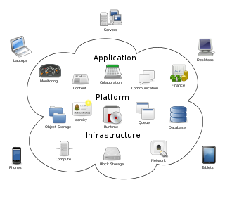
Cloud computing is the on-demand availability of computer system resources, especially data storage and computing power, without direct active management by the user. Large clouds often have functions distributed over multiple locations, each of which is a data center. Cloud computing relies on sharing of resources to achieve coherence and typically uses a pay-as-you-go model, which can help in reducing capital expenses but may also lead to unexpected operating expenses for users.

Gliding is a recreational activity and competitive air sport in which pilots fly unpowered aircraft known as gliders or sailplanes using naturally occurring currents of rising air in the atmosphere to remain airborne. The word soaring is also used for the sport.
Aikido concepts are ideas that form the philosophical or technical basis of the Japanese martial art aikido.
Cloud rap is a subgenre of rap that has several sonic characteristics of trap music and is known for its hazy, dreamlike and relaxed production style. Rapper Lil B and producer Clams Casino have been identified as the early pioneers of the style. The term "cloud rap" is derived from its internet origins and ethereal style.