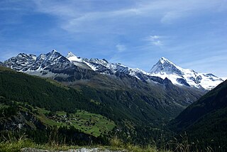
Mont Blanc, meaning "White Mountain", is the highest mountain in the Alps and the highest in Europe west of Russia's Caucasus peaks. It rises 4,808.7 m (15,777 ft) above sea level and is ranked 11th in the world in topographic prominence. The mountain stands in a range called the Graian Alps, between the regions of Aosta Valley, Italy, and Savoie and Haute-Savoie, France. The location of the summit is on the watershed line between the valleys of Ferret and Veny in Italy and the valleys of Montjoie, and Arve in France, in the middle of what is generally considered to be the border between the two countries.

The Haute Route, is the name given to a route undertaken on foot or by ski touring between Chamonix in France and Zermatt in Switzerland.

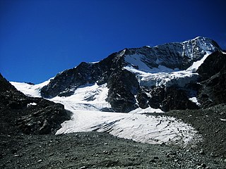
The Mont Blanc massif is a mountain range in the Alps, located mostly in France and Italy, but also straddling Switzerland at its northeastern end. It contains eleven major independent summits, each over 4,000 metres (13,123 ft) in height. It is named after Mont Blanc, the highest point in western Europe and the European Union. Because of its considerable overall altitude, a large proportion of the massif is covered by glaciers, which include the Mer de Glace and the Miage Glacier – the longest glaciers in France and Italy, respectively.

The Bertol Hut is a mountain hut overlooking the Bertol Pass, south of Arolla in the Swiss canton of Valais. It is known for its precarious position on a ridge at 3,311 metres (10,863 ft) south of the Pointe de Bertol and is accessed by a number of fixed ladders and chains from the glacier pass. All accesses to the hut involve glacier crossing. On its east side it overlooks the large plateau of the Mont Miné Glacier.
Val d'Hérens is an alpine valley in the Valais canton of Switzerland. It was formed by the Hérens glacier, which retreated at the end of the last ice age. It is now the valley of the Borgne river, a tributary of the Rhone

Mont Maudit is a mountain in the Mont Blanc massif in France and Italy. The French name literally means "Cursed Mountain". Until the end of the 18th century, Mont Blanc and its satellite peaks were collectively known in French as the Montagne Maudite.

Mont Blanc de Cheilon is a mountain of the Pennine Alps, located in the Swiss canton of Valais. The mountain lies between the valleys of Bagnes and Arolla. Culminating at 3,870 metres above sea level, it is one of the highest summits between the Grand Combin to the west and the Dent Blanche to the east. The massif is glaciated, with the Cheilon Glacier to the north, the Giétro Glacier to the west, the Brenay Glacier to the south and the Tsijiore Nouve Glacier to the east.
Horace Walker (1838–1908) was an English mountaineer who made many notable first ascents, including Mount Elbrus and the Grandes Jorasses.

The Saleina Hut is a mountain hut in the Swiss Alps at 2,691 meters above sea level. It can be reached from the Val Ferret. The hut lies above the Saleina Glacier near the Aiguille d'Argentière in the Mont Blanc Massif, and has places for 48 people and is wardened between mid-June to mid-September.
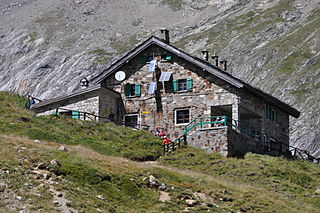
The Cabane de l'A Neuve is a mountain hut in the Swiss Alps at 2,735 metres above sea level open for visitors. It can be reached from the Val Ferret. The hut lies below the Grand Darray on the south side in the Mont Blanc Massif. Other summits close to the hut are the Tour Noir, the Grande Lui and the Mont Dolent. Inauguration was 4 September 1927.

The Vignettes Hut is an alpine hut, located south of Arolla in the Swiss canton of Valais. It lies at a height of 3,160 metres above sea level, at the foot of the Pigne d'Arolla and near the Col de Chermotane in the Pennine Alps. All accesses to the hut involve glacier crossing.

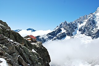
The Argentière Hut is a refuge in the Mont Blanc massif in the Alps. Built in 1974 by the Club Alpin Français, it is located above the north bank of the Argentière Glacier in France at an altitude of 2,691 meters above sea level.

The Cosmiques Hut is a mountain hut in the Mont Blanc massif in the French Alps at an altitude of 3,613 m. It is a large structure capable of accommodating 148 mountaineers. It was constructed in 1990 on a rock promontory situated between the Col du Midi and the base of the Cosmiques Arête which descends southwards from the Aiguille du Midi. It gives access to a number of classic alpine mountaineering routes, and has proved to be extremely popular with mountaineers, so much so that in the summer months prior booking a few days beforehand is essential in order to secure a bed. The Hut is wardened between mid-February and mid-October. In winter the nearby Abri Simond Hut is left unlocked, although this has no cooking facilities, heating or water.
Refugio Elisabetta is a refuge in the Italian Alps at an altitude of 2,195 m, which provides a convenient overnight stage for walkers undertaking the Tour du Mont Blanc. It is located 3 km north-east of the Col de la Seigne, at the south-west end of the Mont Blanc massif, and provides good views of Mont Blanc and the Aiguille Noire de Peuterey. Because of its popularity, plus the fact that there are no other huts along this part of the Tour du Mont Blanc, walkers are advised to book in advance during the peak periods in July and August.

The Grands Mulets Hut is a mountain refuge in the Mont Blanc massif in the French Alps at an altitude of 3,051 m. It is owned by the Club Alpin Francais. The hut is located on a pyramidal rock island, at the junction of two streams of the Bossons Glacier on the north side of Mont Blanc. If the state of the glacier is not too severe, the hut is wardened in summer and can be used as an alternative route of ascent to the summit of Mont Blanc, following the original historic route by the first ascensionists. Nowadays the hut is used more frequently by ski-mountaineers in spring, or as a more sheltered and alternative route of descent from Mont Blanc than the much more popular Goûter route, though route-finding can be difficult in fog and requires prior knowledge of the crevassed state of the Bossons glacier below the hut.
The Quintino Sella Hut is a very remote bivouac hut in the Mont Blanc massif of the Alps in Aosta Valley, Italy. Built in the 1920s, it is perched on rocks on the south-western flank of the Rocher du Mont Blanc at an altitude of 3,396 m. It is owned by the CAI and can accommodate up to sixteen people with bunk and blankets provided, but no stove or warden.

The Tête Rousse Hut is a mountain hut in the Mont Blanc massif in the French Alps. It is located beside the Tête Rousse Glacier at an altitude of 3,167 m. Owned by the Club Alpin Francais (CAF), it is normally reached after a multi-hour climb from Nid d'Aigle, the highest stop on the Mont Blanc Tramway. It is commonly used by mountaineers attempting to climb the modern normal route on the French side or Goûter route to the summit of Mont Blanc. Staying here, rather than continuing to the higher Goûter Hut adds an extra 2–3 hours to the ascent of Mont Blanc, but is less cramped than the latter and also avoids having to climb the dangerous 'Grand Couloir' later in the day when the risk of injury from stonefall is at its greatest.
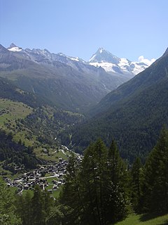
Les Haudères is a village in the Swiss Alps, located in the canton of Valais. The village is situated in the central part of the canton, in the Val d'Hérens, south of Sion. It belongs to the municipality of Evolène.
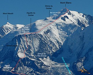
The Goûter Route is one of the two normal mountaineering routes used to reach the summit of Mont Blanc in the Alps, at a height of 4,808 metres (15,774 ft). The route lies on the north side of the mountain, in France. There have been numerous deaths and injuries sustained by climbers on this route, many during their passage of a dangerous couloir which must crossed before reaching the Goûter Refuge - an important staging post and refuge along this extremely popular and often overcrowded route.