Related Research Articles
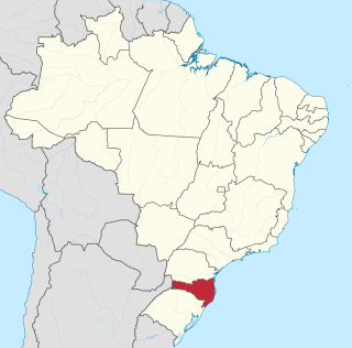
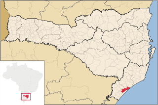
Santa Catarina is a state in the South Region of Brazil. It is the 7th smallest state in total area and the 11th most populous. Additionally, it is the 9th largest settlement, with 295 municipalities. The state, with 3.4% of the Brazilian population, generates 3.8% of the national GDP.
Santa Catarina may refer to:

Florianópolis is the capital and second largest city of the state of Santa Catarina, in the South region of Brazil. The city encompasses Santa Catarina Island and surrounding small islands, as well as part of the mainland. It has a population of 508,826, according to the 2020 IBGE population estimate, the second-most populous city in the state, and the 47th in Brazil. The metropolitan area has an estimated population of 1,111,702, the 21st largest in the country. The city is known for having the country's third highest Human Development Index score among all Brazilian cities (0.847).

Jaraguá do Sul is a city in the north of the Brazilian state of Santa Catarina.

Santa Catarina is a concelho (municipality) of Cape Verde. It is situated in the western part of the island of Santiago. Its seat is the city of Assomada. Its population was 45,920 in 2017 (estimate). Its area is 242.6 km2 (93.7 sq mi).
Araranguá is a city located in the southern part of Santa Catarina state, in the south of Brazil. It has 68,867 inhabitants and was settled mainly by Portuguese and Italians. Araranguá is known as "A Cidade das Avenidas" because of its wide roads.

Itajaí is a municipality in the state of Santa Catarina, Brazil. It is located on the northern central coast of Santa Catarina and is part of the Vale do Itajaí Mesoregion, on the right bank of the Itajaí-Açu river mouth. It lies at the mouth of the Itajaí River, at 20 feet above sea level. The city has the 2nd largest gross domestic product and the highest per capita income in the State of Santa Catarina.

Águas Mornas is a Brazilian municipality in the state of Santa Catarina.

Tubarão is a Brazilian municipality located in southern part of Santa Catarina state. The population, according to the IBGE/2020 estimate was 106,422. It is the main city of the Tubarão River basin region, which comprises 20 municipalities and a population of 350,000 inhabitants.

União da Vitória is a municipality in the state of Paraná in Brazil. Its population was about 57,913 people in 2020. In the economic area, União da Vitória's GDP is US$115,364,648.65.

Campos Novos is a city in Santa Catarina, in the Southern Region of Brazil. Campos Novos is a pioneer in production of pollen and the biggest grain and oat producer of Santa Catarina. The municipality invests also into fat stock and poultry farming.
Pedras Grandes is a municipality in Brazilian State of Santa Catarina.

The coastline of Brazil measures 7,491 km, which makes it the 16th longest national coastline of the world. All the coast lies adjacent to the Atlantic Ocean.

Alfredo Wagner is a municipality in the state of Santa Catarina in the South region of Brazil.
Arroio Trinta is a municipality in the state of Santa Catarina in the South region of Brazil. The population in 2020 was 3,549 inhabitants.

Caçador is a municipality in the state of Santa Catarina in the South region of Brazil.
Rio do Sul is a municipality in the state of Santa Catarina in the South region of Brazil.

Verride Palace, or the Palace of Santa Catarina, is an 18th-century Portuguese palace located in Lisbon, Portugal.
References
- Map from Ministry of Transport