Related Research Articles

Rio de Janeiro, or simply Rio, is the capital of the state of the same name, Brazil's third most populous state, and the second most populous city in Brazil, after São Paulo. Listed by the GaWC as a beta global city, Rio de Janeiro is the sixth most populous city in the Americas. Part of the city has been designated as a World Heritage Site, named "Rio de Janeiro: Carioca Landscapes between the Mountain and the Sea", on 1 July 2012 as a Cultural Landscape.

Rio de Janeiro is one of the 27 federative units of Brazil. It has the second largest economy of Brazil, with the largest being that of the state of São Paulo. The state, which has 8.2% of the Brazilian population, is responsible for 9.2% of the Brazilian GDP.
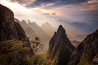
Serra dos Órgãos National Park is a national park in the state of Rio de Janeiro, Brazil. It protects the Serra dos Órgãos mountain range and the water sources in the range. It was the third national park to be created in Brazil.

Agenor de Miranda Araújo Neto, better known as Cazuza, was a Brazilian singer and songwriter, born in Rio de Janeiro. Along with Raul Seixas, Renato Russo and Os Mutantes, Cazuza, both while fronting Barão Vermelho and at solo career, is considered one of the best exponents of Brazilian rock music. In his 9-year career, he sold more than 5 million albums and achieved 11 number one singles and 18 Top 10 singles in Brazil.
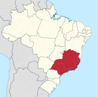
The Southeast Region of Brazil is composed of the states of Espírito Santo, Minas Gerais, Rio de Janeiro and São Paulo. It is the richest region of the country, responsible for approximately 60% of the Brazilian GDP, as São Paulo, Rio de Janeiro, and Minas Gerais are the three richest states of Brazil, the top three Brazilian states in terms of GDP. The Southeast of Brazil also has the highest GDP per capita among all Brazilian regions.
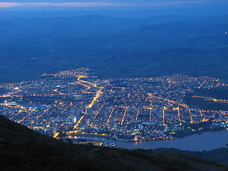
Governador Valadares is a Brazilian municipality in the countryside of Minas Gerais. In 2020, its population was 281,046 inhabitants, thus being the ninth most populated city in the state. It is an economical axis of the middle valley of the Doce River, having a significant influence on the east and northeast portion of Minas Gerais and local authorities of the state of Espírito Santo. Governador Valadares sits on the bank of the Doce River, 324 km from Belo Horizonte, the state's capital. Governador Valadares has an area of about 2 342 km2, being only 58 km2 of urban area.

Nova Iguaçu is a municipality in Rio de Janeiro state in Brazil.

Campos dos Goytacazes is a municipality located in the northern region of Rio de Janeiro State, Brazil, with a population of 471,737 inhabitants.
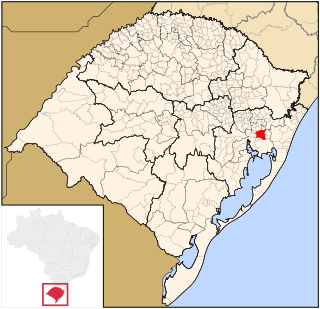
Gravataí is a Brazilian municipality near Porto Alegre at the Rio Grande do Sul State. Its population is approximately 280,000 people, making it the sixth most populous city in the state.

Espera Feliz is a municipality in southeastern Minas Gerais state, Brazil. The altitude is 2,430 m above sea level. Located at 20°39′00″S41°54′25″W, its neighboring cities are Caiana to the south, Dores do Rio Preto to the east, Divino to the west, Alto Caparaó and Caparaó to the north and Carangola to the southwest.

Bom Jesus do Itabapoana is a municipality in the Brazilian state of Rio de Janeiro. It had a population of 37,203 as of 2020, and has an area of 598,8 km2. It was founded in 1939, after being separated from the municipality of Itaperuna.

Nepomuceno is a Brazilian municipality located in the south of the state of Minas Gerais. The population in 2020 was 26,826 in a total area of 584 km2 (225 sq mi). The maximum elevation is 1,100 m (3,600 ft) and the minimum is 850 m (2,790 ft).
The Flamengo Basketball team is a professional Brazilian basketball team based in Rio de Janeiro. It is a part of the Clube de Regatas do Flamengo multi-sports club family. The club's full name is Basquetebol do Clube de Regatas do Flamengo. The club's commonly used short names are C.R.F. Basquete, C.R. Flamengo Basquete, Flamengo Basquete, and FlaBasquete.
The Bela Joana River is a river of Rio de Janeiro state in southeastern Brazil.
The Imboacica River is a river of Rio de Janeiro state in southeastern Brazil.
The Macabu River is a river of Rio de Janeiro state in southeastern Brazil.
The Pavuna River is a river of Rio de Janeiro state in southeastern Brazil.
The Queimados River is a river of Rio de Janeiro state in southeastern Brazil.
The São João de Meriti River is a river of Rio de Janeiro state in southeastern Brazil.

A series of floods and mudslides took place in January 2011 in several towns of the Mountainous Region, in the Brazilian state of Rio de Janeiro. Casualties occurred in the cities of Nova Friburgo, Teresópolis, Petrópolis, Bom Jardim, Sumidouro and São José do Vale do Rio Preto. The floods caused at least 916 deaths, including 424 in Nova Friburgo and 378 in Teresópolis. While local media claims that the combination of floods, mudslides and landslides in Rio de Janeiro became the worst weather-related natural disaster in Brazilian history, some contend that a similar weather-related tragedy that took place in the same state in 1967 was much deadlier, and that an estimated 1,700 people lost their lives on that occasion.
References
Coordinates: 21°36′S41°48′W / 21.600°S 41.800°W