
Mount Victoria is a prominent hill 196 metres (643 ft) high immediately to the east of central Wellington, New Zealand. About 4 kilometres due south is a spur named Mount Albert and the two are linked by a ridge. Mount Victoria's residential area is on its north-western slopes.

William Barnard Rhodes, casually referred to as Barney Rhodes, was a New Zealand landowner, pastoralist, businessman and politician. He was probably born in Lincolnshire, England, but took up a career at sea at an early age. In 1839 he settled in Wellington New Zealand and remained there for the rest of his life. He brought three of his younger brothers to New Zealand and they co-ordinated their efforts.

Karori is a suburb located at the western edge of the urban area of Wellington, New Zealand, 4 km from the city centre and is one of New Zealand's most populous suburbs, with a population of 15,320 in June 2022.

The Museum of New Zealand Te Papa Tongarewa is New Zealand's national museum and is located in Wellington. Usually known as Te Papa, it opened in 1998 after the merging of the National Museum of New Zealand and the National Art Gallery. An average of more than 1.5 million people visit every year, making it the 26th-most-visited art gallery in the world. Te Papa operates under a bicultural philosophy, and emphasises the living stories behind its cultural treasures.

Thorndon is a historic inner suburb of Wellington, the capital city of New Zealand. Because the suburb is relatively level compared to the hilly terrain elsewhere in Wellington it contained Wellington's elite residential area until its best was destroyed in the 1960s by a new motorway and the erection of tall office buildings on the sites of its Molesworth Street retail and service businesses.

The Aro Valley forms a small inner-city suburb of Wellington in New Zealand. It takes its name from the stream which originally flowed where modern Epuni Street is. The stream's Māori name was originally Wai-Mapihi, but it was commonly called Te Aro Stream due to it running through the Te Aro flat.
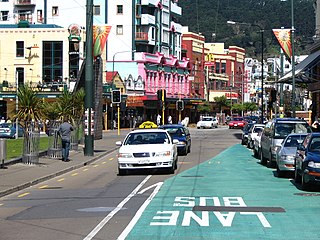
Te Aro is an inner-city suburb of Wellington, New Zealand. It comprises the southern part of the central business district including the majority of the city's entertainment district and covers the mostly flat area of city between The Terrace and Cambridge Terrace at the base of Mount Victoria.

Wellington railway station, or Wellington Central station, is the main railway station serving Wellington, New Zealand, and is the southern terminus of the North Island Main Trunk, Wairarapa Line and Johnsonville Line.
Wellington City Libraries is the public library service for Wellington, New Zealand.

The Majestic Centre, designed by Jack Manning of Manning Mitchell in association with Kendon McGrail of Jasmax Architects, was completed in 1991. The main building of the Majestic Centre is the Majestic Tower which is the tallest building in Wellington, New Zealand. The building, located on 100 Willis Street is 116 metres (381 ft) high and has 29 above ground storeys, making it the twelfth-tallest skyscraper building in New Zealand, along with the ASB Bank Centre in Auckland. It was, at the time of its completion, one of the three tallest buildings in the country, the two other contenders being built in the same year. It is to this day the furthest south 100M+ skyscraper in the world. It is mainly used as office space.
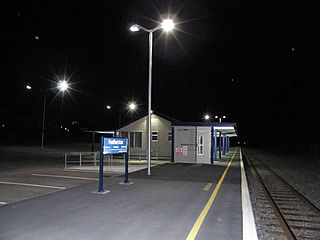
Featherston railway station is a single-platform, urban railway station serving the town of Featherston in the Wairarapa district of New Zealand. The station lies on the Wairarapa Line, and is located between Harrison Street West and Harrison Street East. It is thirty-five minutes journey time to Masterton, or fifty five minutes journey time to Wellington.
Sir James Fletcher was a New Zealand industrialist who founded Fletcher Construction, one of the country's largest firms. His son, Sir James Fletcher Junior, continued to build the corporation.

Northland is an affluent suburb in west-central Wellington, New Zealand. Not far from Victoria University it also includes low-priced accommodation popular with young students. It borders the suburbs of Highbury, Kelburn, Thorndon, Wilton, Wadestown and Karori. Northland is populated by a mix of university students, young professionals and families. Part of the area was known as Creswick until the late 19th century when new roads and building sites were developed by the landowner, C J Pharazyn, who marketed the whole area as Northland. At that time it was described in the now defunct Evening Post as "Wellington's best suburb".

The Dominion Museum building on Mount Cook in Buckle Street Wellington completed in 1936 and superseded by Te Papa in 1998 was part of a war memorial complex including a Carillon and National War Memorial.

Kirkcaldie & Stains was a mid-sized department store in Wellington, New Zealand. It was established in 1863 by John Kirkcaldie and Robert Stains with a capital of £700. The first store was opened on Lambton Quay. In 1868 Kirkcaldie & Stains moved to their final location at the corner of Lambton Quay and Brandon Street, expanding several times. There was a branch in Napier from 1897 until 1917, and a branch on Cuba Street, Wellington for seven years (1871–76). French luxury skincare brand Sisley was exclusive to the store in New Zealand.

The Victoria University Coastal Ecology Laboratory (VUCEL) is a research facility of the School of Biological Sciences at Victoria University of Wellington that supports research in coastal ecology and marine biology. Located at the southern end of the North Island of New Zealand, in Island Bay on Wellington's south coast, approximately 8 km south of the university's main campus, the laboratory overlooks Cook Strait and the exposed rocky reef systems of the Taputeranga Marine Reserve.

Te Aro railway station was a station in Wellington, New Zealand, near what is now the corner of Wakefield and Tory Streets. Opened in 1893 it was one of only three stations in the city - the other two were Wellington railway station on Featherston Street, renamed Lambton railway station in December 1908, which was the main New Zealand Railways Department station, and Thorndon railway station off Thorndon Quay, the southern terminus of the private Wellington and Manawatu Railway.

Lambton originally Wellington railway station in Featherston Street, Wellington, New Zealand was the southern passenger terminus for the Hutt Line and the Wairarapa Line from 1885 to 1936 and for lines further north until December 1908. Wellington's third railway station it had been preceded by station buildings temporarily at Pipitea Point and a site further south on Featherston Street beside Wellington's rail freight depot and its Railway Wharf.

Featherston Military Camp, on a "windswept grassy plain" 3 kilometres north of Featherston, New Zealand was built —after the announcement of National Registration of all military-aged men— to supplement Trentham Military Camp on the other side of the Rimutaka hill. The National Registration actually took place in October and November 1915 but the bill empowering conscription by the government did not pass until 1 August 1916.
Whitmore Street is at the boundary of the central business district and the government buildings area of Wellington, New Zealand's capital. The street runs almost north-south and is one of those linking Lambton Quay, Wellington's main shopping street, with Stout Street, Featherston Street and the harbourside at Customhouse/ Waterloo Quay. It is in the suburb of Pipitea.


