Domoko

Last updated

Domoko is a ruined village site [1] (known as Old Domoko) located in the eastern region of the Khotan oasis in China, about 20 kilometers north the Domoko administrative center, [2] on the southern arm of the Silk Road. The site is located in the Xinjiang autonomous region.

China State in East Asia

China, officially the People's Republic of China (PRC), is a country in East Asia and the world's most populous country, with a population of around 1.404 billion. Covering approximately 9,600,000 square kilometers (3,700,000 sq mi), it is the third- or fourth-largest country by total area. Governed by the Communist Party of China, the state exercises jurisdiction over 22 provinces, five autonomous regions, four direct-controlled municipalities, and the special administrative regions of Hong Kong and Macau.

Silk Road trade routes through Asia connecting Chinza to the Mediterranean Sea

The Silk Road was an ancient network of trade routes that connected the East and West. It was central to cultural interaction between the regions for many centuries. The Silk Road primarily refers to the terrestrial routes connecting East Asia and Southeast Asia with East Africa, West Asia and Southern Europe.

Xinjiang Autonomous region

Xinjiang, officially the Xinjiang Uygur Autonomous Region (XUAR), is a provincial-level autonomous region of China in the northwest of the country. It is the largest Chinese administrative division and the eighth largest country subdivision in the world, spanning over 1.6 million km2. Xinjiang contains the disputed territory of Aksai Chin, which is administered by China and claimed by India. Xinjiang borders the countries of Mongolia, Russia, Kazakhstan, Kyrgyzstan, Tajikistan, Afghanistan, Pakistan (Gilgit-Baltistan), and India. The rugged Karakoram, Kunlun, and Tian Shan mountain ranges occupy much of Xinjiang's borders, as well as its western and southern regions. Xinjiang also borders Tibet Autonomous Region and the provinces of Gansu and Qinghai. The most well-known route of the historical Silk Road ran through the territory from the east to its northwestern border. In recent decades, abundant oil and mineral reserves have been found in Xinjiang, and it is currently China's largest natural gas-producing region.

Contents

The village was abandoned in the middle of the 19th century because the shortage of water-supply and the consequently shift of cultivation, according to the local villagers.

Archaeology

Domoko was explored by Sir Aurel Stein in 1906 on his first Central Asia expedition. [3] Stein found an abandoned village and described the archaeological remains and conservation conditions of the buildings:

Aurel Stein Hungarian-British archaeologist

Sir Marc Aurel Stein, (Hungarian: Stein Márk Aurél; 26 November 1862 – 26 October 1943) was a Hungarian-born British archaeologist, primarily known for his explorations and archaeological discoveries in Central Asia. He was also a professor at Indian universities.

Here we had reached the southern edge of 'old Domoko', an area covered with the remains of a deserted village group. The crumbling ruins of mud-built dwellings, constructed and arranged exactly as in the now inhabited villages of this tract and forming detached groups, seemed to extend, together with the interspersed orchards, cemeteries and fields, for about three miles from east to west. Going towards the north-west we kept between them for nearly three miles. The mud-walls, strengthened by the insertion of vertical bundles of Kumush, still rose often 4 to 5 ft. above the ground, and the massive fireplaces were intact even to a greater height […] The deserted homesteads had been stripped of all materials that could be of use, such as beams, wooden doorposts, &c. As scarcely any sand had accumulated about the crumbling ruins, their rapid and complete disappearance seemed inevitable as soon as erosion set in. [4]
Aurel Stein, Ancient Khotan: Vol. I p. 458

Excavations were apparently "rushed" as Stein was keen to return to Niya, a site where he was carrying out more thorough excavations. [3]

Art and Artefacts

The finds from Domoko appear to have consisted primarily of wooden panels, located in the ruins of a sanctuary near the oasis. [5] The rectangular panels were painted with images of Buddha, Bodhisattvas and various other Buddhist-Hindu deities. [6] One of key points of interest relating to the Silk Roads is the exchange of ideas, particularly in regards to technology and religion. Some of the most significant finds have been those related to the development and expansion of Buddhism in China. The most famous examples are the silk paintings and scrolls found at Dunhuang and given to the British Museum by Aurel Stein.

Buddhism World religion, founded by the Buddha

Buddhism is the world's fourth-largest religion with over 520 million followers, or over 7% of the global population, known as Buddhists. Buddhism encompasses a variety of traditions, beliefs and spiritual practices largely based on original teachings attributed to the Buddha and resulting interpreted philosophies. Buddhism originated in ancient India as a Sramana tradition sometime between the 6th and 4th centuries BCE, spreading through much of Asia. Two major extant branches of Buddhism are generally recognized by scholars: Theravada and Mahayana.

Dunhuang County-level city in Gansu, Peoples Republic of China

Dunhuang is a county-level city in northwestern Gansu Province, Western China. The 2000 Chinese census reported a population of 187,578 in this city. Dunhuang was a major stop on the ancient Silk Road and is best known for the nearby Mogao Caves. It has also been known at times as Shazhou and, in Uyghur, Dukhan.

Oases and UNESCO

More recently the oases of the Silk Road have re-entered archaeological discourse. As UNESCO tries to incorporate a more diverse range of sites into its 'World Heritage' portfolio, the concept of 'serial nominations' has emerged. The oases positioned along the Silk Road were pivotal to its existence, providing fresh supplies and diverse markets to the trading caravans. Nominations for the sites that made up the 'Silk Road's Oasis Route in China' are now being identified, and will make up a part of the far more extensive serial nomination, the aim of which is to include key sites across the entire Silk Road route. [7]

UNESCO Specialised agency of the United Nations

The United Nations Educational, Scientific and Cultural Organization is a specialized agency of the United Nations (UN) based in Paris. Its declared purpose is to contribute to peace and security by promoting international collaboration through educational, scientific, and cultural reforms in order to increase universal respect for justice, the rule of law, and human rights along with fundamental freedom proclaimed in the United Nations Charter. It is the successor of the League of Nations' International Committee on Intellectual Cooperation.

World Heritage Site place listed by the UNESCO as of special cultural or natural significance

A World Heritage Site is a landmark or area which is selected by the United Nations Educational, Scientific and Cultural Organization (UNESCO) as having cultural, historical, scientific or other form of significance, and is legally protected by international treaties. The sites are judged important to the collective interests of humanity.

Related Research Articles

Taklamakan Desert Desert in Xinjiang Uyghur Autonomous Region, China

The Taklamakan Desert, also spelled "Taklimakan" and "Teklimakan", is a desert in southwest Xinjiang in Northwest China. It is bounded by the Kunlun Mountains to the south, the Pamir Mountains and Tian Shan to the west and north, and the Gobi Desert to the east.

Hotan County-level city in Xinjiang, Peoples Republic of China

Hotan, is a major oasis town in southwestern Xinjiang, an autonomous region in western China. The city proper of Hotan broke off from the larger Hotan County to become an administrative area in its own right in August 1984. It is the seat of Hotan Prefecture.

Kingdom of Khotan former country

The Kingdom of Khotan was an ancient Iranian Saka Buddhist kingdom located on the branch of the Silk Road that ran along the southern edge of the Taklamakan Desert in the Tarim Basin. The ancient capital was originally sited to the west of modern-day Hotan at Yotkan. From the Han dynasty until at least the Tang dynasty it was known in Chinese as Yutian. This largely Buddhist kingdom existed for over a thousand years until it was conquered by the Muslim Kara-Khanid Khanate in 1006, during the Islamicisation and Turkicisation of Xinjiang.

Tarim Basin geographical area in asia, in the west of current China

The Tarim Basin is an endorheic basin in northwest China occupying an area of about 1,020,000 km2 (390,000 sq mi). Located in China's Xinjiang region, it is sometimes used synonymously to refer the southern half of the province, or Nanjiang, as opposed to the northern half of the province known as Dzungaria or Beijiang. Its northern boundary is the Tian Shan mountain range and its southern boundary is the Kunlun Mountains on the edge of the Tibetan Plateau. The Taklamakan Desert dominates much of the basin. The historical Uyghur name for the Tarim Basin is Altishahr (六域), which means "six cities" in Uyghur.

Tashkurgan Town in Xinjiang, China

Tashkurgan is the principal town and seat of Tashkurgan Tajik Autonomous County, Xinjiang, China.

Keriya Town County-level city in Xinjiang, Peoples Republic of China

Keriya Town or Mugala Town is a town in Yutian (Keriya) County, Xinjiang, China, on the old Southern Silk Road. As the commercial and administrative centre of Keriya County, it is about 166 km east of Hotan, 80 km east of Qira, and 120 km west of Niya. Yutian County has a population of about 160,000.

Niya Town Town in Xinjiang, China

Niya, is a town in Minfeng County, Xinjiang Uygur Autonomous Region, China.

Jiaohe ruins

Jiaohe or Yarkhoto is a ruined city in the Yarnaz Valley, 10 km west of the city of Turpan in Xinjiang Uyghur Autonomous Region, China. It was the capital of the Jushi Kingdom. It is a natural fortress located atop a steep cliff on a leaf-shaped plateau between two deep river valleys.

Dandan Oilik archaeological site

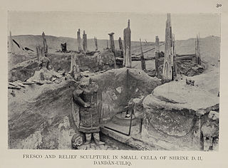
Dandan Oilik, also Dandān-Uiliq, lit. "the houses with ivory", is an abandoned historic oasis town and Buddhist site in the Taklamakan Desert of China, located to the northeast of Khotan in what is now the autonomous region of Xinjiang, between the Khotan and Keriya rivers. The central site covers an area of 4.5 km2; the greater oasis extends over an area of 22 km2. The site flourished from the sixth century as a site along the southern branch of the Silk Road until abandonment before the Tibetan advance at the end of the eighth century.

Niya ruins archaeological site

The Niya ruins, is an archaeological site located about 115 km (71 mi) north of modern Niya Town on the southern edge of the Tarim Basin in modern-day Xinjiang, China. The ancient site was known in its native language as Caḍ́ota, and in Chinese during the Han Dynasty as Jingjue. Numerous ancient archaeological artifacts have been uncovered at the site.

Miran (Xinjiang) archaeological site

Miran is an ancient oasis town located on the southern rim of the Taklamakan Desert in Xinjiang, Northwest China. It lies on the famous trade route known as the Silk Road where the Lop Nur desert meets the Altun Shan mountains. Two thousand years ago a river flowed down from the mountain and Miran had a sophisticated irrigation system. Now the area is a sparsely inhabited, dusty region with poor roads and minimal transportation. Archaeological excavations since the early 20th century have uncovered an extensive Buddhist monastic site that existed between the 2nd to 5th centuries AD, as well as the Miran fort, a Tibetan settlement during the 8th and 9th centuries AD.

Charklik (ancient settlement)

Charklik, Charkhlik is an archeology site located in what is now officially Ruoqiang (Qakilik) County, in the Xinjiang Uyghur Autonomous Region of the People's Republic of China. Together with the nearby Miran site, they correspond to two ancient capitals of Shanshan, Wuni and Yixun. However, it is yet to be cleared which site correspond to which capital.

Shikshin Temple

The Qigexing Temple is a ruined compound of Buddhist sites located about 25–30 km southwest of the town of Karasahr, Yanqi Hui Autonomous County, Xinjiang, China. The site was a major religious center along the northern route of the Silk Road in the second half of the first millennium CE.

Buddhism in Khotan comprised bodies of Buddhist religious doctrine and institutions characteristic of the Iranic Kingdom of Khotan as well as much of Western China and Tajikistan. It was the state religion of the Kingdom of Khotan until its collapse in 1000. Influenced by Mahayana Buddhism, the kingdom's vast collection of texts, which included the indigenous Book of Zambasta and a Khotanese translation of the Sanghata Sutra, helped Khotan influence the Buddhist practices of its neighbors, most notably Tibet.

Balawaste is an archaeological site in the eastern part of the Khotan oasis, near the village of Domoko on the southern arm of the Silk Road. It included a small room, an animal pen and a Buddhist shrine.

Mazar Tagh

Mazar Tagh is the site of a ruined hill fort in the middle of the Taklamakan desert, dating from the time of the Tibetan Empire. Like the Miran fort site, its excavation has yielded hundreds of military documents from the 8th and 9th century, which are among the earliest surviving Tibetan manuscripts, and vital sources for understanding the early history of Tibet. The site is now located north of the modern city of Hotan in the Xinjiang Autonomous Region of the People's Republic of China.

Rawak Stupa

Rawak is a Buddhist stupa located on the southern rim of the Taklamakan Desert in China, along the famous trade route known as the Silk Road in the first millennium Kingdom of Khotan. Around the stupa there are other smaller structures which were originally decorated with a large number of colossal statues. The courtyard of the temple was surrounded by a wall, which contained terracotta relieves and some wall-paintings. The stupa and other structures form a three-dimensional mandala. The site is now about 40 km north of the modern city of Hotan in Xinjiang Autonomous Region of the People's Republic of China.

Miran fort

Miran fort is a ruined defensive structure in Miran, Xinjiang, China. The fort was active during the Tibetan Empire, in the 8th and 9th centuries AD. It is similar in structure to the fort at Mazar Tagh, which was also used by the Tibetan army in the same period. Like the Mazar Tagh site, the excavation of the fort at Miran has yielded hundreds of military documents from the 8th and 9th century, which are among the earliest surviving Tibetan manuscripts, and vital sources for understanding the early history of Tibet.

The concept of the Silk Road has fascinated Europeans for more than a century, symbolizing the exchange between the West and the East since Antiquity. However, the issue of what route was followed by it was not an easy one to resolve. The first person to explore this in detail was Aurel Stein, coming from the west through Kashgar and entering the Taklamakan desert in September 1900, before heading south to Khotan on his first expedition to Serindia. Stein was to come back several times, extending his research area to increase the known sites along the Silk Road in this region.

References

  1. "Stein Placename Database" . Retrieved 25 October 2012.
  2. "Encyclopedia Iranica" . Retrieved 25 October 2012.
  3. 1 2 Escauriaza-Lopez, Valencia. Aurel Stein's Methods and Aims in Archaeology on the Silk Road (PDF).
  4. "Digital Archive of Toyo Bunko Rare Books". National Institute of Informatics. Retrieved 25 October 2012.
  5. Boulnois, Luce (2003). On the Road: Monks, Warriors and Merchants on the Silk Road. p. 184.
  6. Bhattachrya, Chhaya (1977). Art of Central Asia, with special reference to wooden objects from the Northern Silk Road. p. 30.
  7. van Oers, Ron (2004). "Nomination of the Silk Road in China to UNESCO's World Heritage List: Proposals for a Strategic Approach and Reference Framework for Heritage Routes": 62–71.