Dondușeni, Dondușeni

Last updated
Dondușeni
Village
Moldova adm location map.svg
Red pog.svg
Dondușeni
Coordinates: 48°13′28″N27°35′07″E / 48.2244444444°N 27.5852777778°E / 48.2244444444; 27.5852777778
CountryFlag of Moldova.svg  Moldova
District Dondușeni District
Government
  Mayor Ion Zloi (PCRM [1] )
Population (2014 census) [2]
  Total 1,532
Time zone EET (UTC+2)
  Summer (DST) EEST (UTC+3)

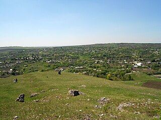
Dondușeni is a village in Dondușeni District, in northern Moldova, with a population of 1,695 at the 2004 census. [3]

Dondușeni District District in Republic of Moldova

Dondușeni District is a district (raion) in the north of Moldova. Its administrative center is the city of Dondușeni. As of 2011, its population was 45,100.

Moldova republic in Eastern Europe

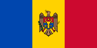
Moldova, officially the Republic of Moldova, is a landlocked country in Eastern Europe, bordered by Romania to the west and Ukraine to the north, east, and south. The capital city is Chișinău.

The 2004 Republic of Moldova Census was carried out between October 5 and October 12, 2004. The breakaway Transnistria failed to come into an agreement with the central government in Chişinău, and carried out its own census between November 11 and November 18, 2004. The results of the census in Transnistria were put into question.

At the 1930 census, the locality had a population of 1,568. It was part of Plasa Climăuți of Soroca County.

Plasă

Plasă was a territorial division unit of Romania, ranking below county (județ) and above commune. It was headed by a Pretor, appointed by the county Prefect. The institution headed by the Pretor was called Pretură.

Soroca County (Romania) County in Romania

Soroca County was a county in the Kingdom of Romania. The seat was Soroca.

Ethnic composition
Ethnic group1930 census2004 census
Moldovans N/A1,622
Romanians 1,4678
Ruthenians (Ukrainians)-34
Russians 8021
Jews 14-
Poles 6-
Gypsies -5
Bulgarians -2
Gagauzians -1
Hungarians 12
others-
Total1,5681,695
Native language
Language1930 census2004 census
Romanian 1,464N/A
Ukrainian -N/A
Russian 88N/A
Yiddish 14N/A
Polish 1N/A
Hungarian 1N/A
Total1,5681,695

Related Research Articles

Crișcăuți Village in Moldova

Crișcăuți is a village in Dondușeni District, Moldova.

Goleni Village in Moldova

Goleni is a village in Edineț District, Moldova.

Chetroșica Nouă Village in Moldova

Chetroșica Nouă is a village in Edineț District, Moldova.

Fetești, Edineț Village in Moldova

Fetești is a village in Edineț District, Moldova.

Bleșteni Commune in Moldova

Bleşteni is a commune in Edineţ district, Moldova. It is composed of two villages, Bleşteni and Volodeni. Bleşteni is the smaller of the two.

Briceni, Dondușeni Village in Moldova

Briceni is a village in Dondușeni District, in northern Moldova.

Ocnița Town in Moldova

Ocnița is a town and the administrative center of Ocnița District, Moldova.

Drochia, Drochia Village in Moldova

Drochia is a village in Drochia District, in the north of Moldova. At the 2004 census, it had a population of 2,843.

Aluatu Village in Moldova

Aluatu is a village in Taraclia District, Moldova.

Balabanu Village in Moldova

Balabanu is a village in Taraclia District, Moldova.

Țaul Village in Moldova

Țaul is a village in Dondușeni District, Moldova.

Pivniceni Village in Moldova

Pivniceni is a village in Dondușeni District, Moldova.

Climăuți Village in Moldova

Climăuți is a village in Dondușeni District, Moldova.

Cernoleuca Village in Moldova

Cernoleuca is a village in Dondușeni District, Moldova.

Plop, Dondușeni Village in Moldova

Plop is a village in Dondușeni District, Moldova.

Pocrovca Village in Moldova

Pocrovca is a village in Dondușeni District, Moldova.

Scăieni Village in Moldova

Scăieni is a village in Dondușeni District, Moldova.

Baraboi, Dondușeni Village in Moldova

Baraboi is a village in Dondușeni District, Moldova.

References

Coordinates: 48°13′N27°35′E / 48.217°N 27.583°E / 48.217; 27.583

Geographic coordinate system Coordinate system

A geographic coordinate system is a coordinate system that enables every location on Earth to be specified by a set of numbers, letters or symbols. The coordinates are often chosen such that one of the numbers represents a vertical position and two or three of the numbers represent a horizontal position; alternatively, a geographic position may be expressed in a combined three-dimensional Cartesian vector. A common choice of coordinates is latitude, longitude and elevation. To specify a location on a plane requires a map projection.