This is a list of the extreme points of the United Kingdom: the points that are farther north, south, east or west than any other location. Traditionally the extent of the island of Great Britain has stretched "from Land's End to John o' Groats".

Santiago Tangamandapio, known as Tangamandapio, is a municipality in the Mexican state of Michoacán. It is located 165 km from the state capital of Morelia. The geographic coordinates are: 19° 57' North latitude and 102° 26' West longitude. Tangamandapio Municipality also includes the community of Tarécuato.
San Francisco del Valle is a municipality in the Honduran department of Ocotepeque.

Acquarossa is the capital of the district of Blenio in the canton of Ticino in Switzerland.

Mogno is a village in Vallemaggia District in the canton of Ticino, Switzerland. Mogno is situated near the top of Val Lavizzara, a valley through which the upper Maggia river flows. Formerly part of the municipality of Fusio, which merged with adjoining municipalities in 2004 to form the new municipality of Lavizzara.

Ordas is a village and municipality in Bács-Kiskun county, in the Southern Great Plain region of southern Hungary.
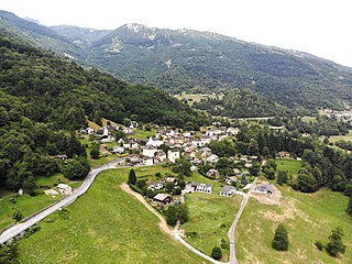
Corzoneso is a village and former municipality in the canton of Ticino, Switzerland.

Largario is a village and former municipality in the canton of Ticino, Switzerland.

Leontica is a village and former municipality in the canton of Ticino, Switzerland.

Lottigna is a village and former municipality in the canton of Ticino, Switzerland.
Marolta is a village and former municipality in the canton of Ticino, Switzerland.

Ponto Valentino is a village and former municipality in the canton of Ticino, Switzerland.
Prugiasco is a village and former municipality in the canton of Ticino, Switzerland.
Esparragalejo is a municipality of Spain in the province of Badajoz, autonomous region of Extremadura.
Egelner Mulde is a Verbandsgemeinde in the Salzlandkreis district, in Saxony-Anhalt, Germany. Before 1 January 2010, it was a Verwaltungsgemeinschaft. The seat of the Verbandsgemeinde is in Egeln.
Castro is a village and former municipality in the canton of Ticino, Switzerland.
Əlirzalı is a village and municipality in the Goranboy Rayon of Azerbaijan. It has a population of 1,006.
Bern-Mittelland District in the Canton of Bern was created on 1 January 2010. It is part of the Bern-Mittelland administrative region, and is the only district in the region. It contains 74 municipalities with an area of 946.30 km2 (365.37 sq mi) and a population of 418,191.
Doddahosur is a small village in Khanapur taluka in Belgaum district in the state of Karnataka, India. Most residents speak Marathi and the rest speak Kannada. The village comes under Lokoli Gram Panchayath and is 26 km south of the city of Belgaum and 5 km from Khanapur. The population is about 1000–1200.
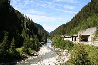
The Ferrera Valley is a valley in the Swiss canton of Graubünden between Schams and Avers. It is 10 km long and is drained by the Avers Rhine. The only villages in the valley are Innerferrera and Ausserferrera. Administratively, the municipality of Ferrera coincides with the valley.