Doolough Tragedy

Last updated

Memorial to the victims in Doolough valley Doolough.jpg
Memorial to the victims in Doolough valley

The Doolough Tragedy was an event that took place during the Great Irish Famine close to Doo Lough in southwest County Mayo. [1] At least seven (and perhaps 20 or significantly more) starving people died after being required to walk a long distance to an inspection by poor law union officials, who would determine whether they would continue to receive outdoor relief. [2] [3] [4]

Events

On Friday 30 March 1849, two officials of the Westport Poor Law Union arrived in Louisburgh to inspect those people in receipt of outdoor relief to verify that they should continue to receive it. [4] The inspection, for some reason, did not take place and the two officials went on to Delphi Lodge – a hunting lodge 19 kilometres (12 miles) south of Louisburgh where they intended to spend the night. [2] Several hundred people who had gathered for the inspection, or later did so, were consequently instructed to appear at Delphi Lodge at 7am the following morning if they wished to continue receiving relief. [5] [3] For much of the night and day that followed seemingly hundreds of destitute and starving people had to undertake what for them, given their existing state of debilitation, was an extremely fatiguing journey, in very bad weather. [4] [6]

A letter-writer to The Mayo Constitution newspaper reported shortly afterwards that the bodies of seven people, including women and children, were subsequently discovered on the roadside between Delphi and Louisburgh overlooking the shores of Doolough lake, [7] and that nine or ten more people never reached their homes. [2] While some sources put the total number of deaths at approximately 20 people, local sources suggest that the number who perished was far higher. [3]

Doolough Pass DooLough Pass Road - BenCreggan - Delphi Pass.JPG
Doolough Pass

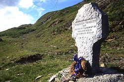
A cross and an annual 'Famine Walk' between Louisburgh and Doolough commemorate the event. [8] The monument in Doolough valley has an inscription from Mahatma Gandhi: "How can men feel themselves honoured by the humiliation of their fellow beings?" [4]

Related Research Articles

<span class="mw-page-title-main">Achill Island</span> Island in County Mayo, Ireland

Achill Island is an island off the west coast of Ireland in the historical barony of Burrishoole, County Mayo. It is the largest of the Irish isles and has an area of approximately 148 km2 (57 sq mi). Achill had a population of 2,345 in the 2022 census. The island, which has been connected to the mainland by a bridge since 1887, is served by Michael Davitt Bridge, between the villages of Achill Sound and Polranny. Other centres of population include the villages of Keel, Dooagh, Dooega, Dooniver, and Dugort. There are a number of peat bogs on the island.

<span class="mw-page-title-main">County Mayo</span> County in Ireland

County Mayo is a county in Ireland. In the West of Ireland, in the province of Connacht, it is named after the village of Mayo, now generally known as Mayo Abbey. Mayo County Council is the local authority. The population was 137,231 at the 2022 census. The boundaries of the county, which was formed in 1585, reflect the Mac William Íochtar lordship at that time.

<span class="mw-page-title-main">Great Famine (Ireland)</span> Famine in Ireland from 1845 to 1852

The Great Famine, also known as the Great Hunger, the Famine and the Irish Potato Famine, was a period of mass starvation and disease in Ireland lasting from 1845 to 1852 that constituted a historical social crisis and had a major impact on Irish society and history as a whole. The most severely affected areas were in the western and southern parts of Ireland—where the Irish language was dominant—hence the period was contemporaneously known in Irish as an Drochshaol, which literally translates to "the bad life" and loosely translates to "the hard times".

<span class="mw-page-title-main">Killary Harbour</span> Sea inlet between Counties Galway and Mayo, Ireland

Killary Harbour or Killary Fjord is a fjord or fjard on the west coast of Ireland, in northern Connemara. To its north is County Mayo and the mountains of Mweelrea and Ben Gorm; to its south is County Galway and the Maumturk Mountains.

<span class="mw-page-title-main">Louisburgh, County Mayo</span> Town in Connacht, Ireland

Louisburgh is a small town on the southwest corner of Clew Bay in County Mayo, Ireland. It is home to Sancta Maria College and the Gráinne O'Malley Interpretive Centre.

<span class="mw-page-title-main">Leenaun</span> Village in Connacht, Ireland

Leenaun, also Leenane, is a village and 1,845 acre townland in County Galway, Ireland, on the southern shore of Killary Harbour and the northern edge of Connemara.

<span class="mw-page-title-main">Murrisk</span> Village near Croagh Patrick, Ireland

Murrisk is a village in County Mayo, Ireland, on the south side of Clew Bay, about 8 km west of Westport and 4 km east of Lecanvey.

<span class="mw-page-title-main">Crossmolina</span> Town in County Mayo, Ireland

Crossmolina is a town in the historical barony of Tyrawley in County Mayo, Ireland, as well as the name of the civil parish and Catholic parish in which the town is situated. The town sits on the River Deel near the northern shore of Lough Conn. Crossmolina is about 9 km (5.6 mi) west of Ballina on the N59 road. Surrounding the town, there are a number of agriculturally important townlands, including Enaghbeg, Rathmore, and Tooreen.

<span class="mw-page-title-main">Erris</span> Barony in County Mayo, Ireland

Erris is a barony in northwestern County Mayo in Ireland consisting of over 230,452 acres (932.61 km2), much of which is mountainous blanket bog. It has extensive sea coasts along its west and north boundaries. The main towns are Belmullet and Bangor Erris. The name Erris derives from the Irish 'Iar Ros' meaning 'western promontory'. The full name is the Iorrais Domnann, after the Fir Bolg tribe, the Fir Domnann. To its north is the wild Atlantic Ocean and the bays of Broadhaven and Sruth Fada Conn and to its west is Blacksod Bay. Its main promontories are the Doohoma Peninsula, Mullet Peninsula, Erris Head, the Dún Chiortáin and Dún Chaocháin peninsulas and Benwee Head.

Events from the year 1849 in Ireland.

Donncha Ó Dúlaing was an Irish broadcaster who was known country-wide and among the Irish around the world for his cultural and traditional music programmes.

Sancta Maria College is a Catholic secondary school located in Louisburgh, County Mayo, Ireland. The school was Ireland's first Catholic co-educational secondary school.

<span class="mw-page-title-main">Doohoma</span> Townland in Connacht, Ireland

Doohoma or Doohooma is a townland, peninsula and a census town in the County Mayo Gaeltacht, Ireland. It is located on Ireland's Atlantic coastline overlooking Achill Island and the Mullet Peninsula.

Afri is a Dublin-based NGO that promotes human rights, peace, justice and environmentalism, especially in the Global South, with a focus on injustice caused by conflict. Its patron is Archbishop Desmond Tutu. Another patron of is former UN Assistant Secretary General Denis Halliday.

Doolough is a coastal townland covering an area of approximately 2,493 acres (10 km2) in the parish of Kiltane, Erris in north County Mayo, Ireland. It is southeast of Belmullet town and is part of the Mayo Gaeltacht.

The National Famine Commemoration Day is an annual observance in Ireland commemorating the Great Famine. A week-long programme of events leads up to the day, usually a Sunday in May. It has been organised officially by the government of Ireland since May 6th 2008. The main event is held in a different place each year, rotating among the four provinces of Ireland. There is also an international event, held in a place important for the Irish diaspora.

<span class="mw-page-title-main">Doo Lough, County Mayo</span> Lake in County Mayo, Ireland

Doo Lough is a freshwater lake in the west of Ireland. It is located in southwest County Mayo on the Murrisk peninsula.

The following is a timeline of the COVID-19 pandemic in the Republic of Ireland in 2021.

<span class="mw-page-title-main">Murrisk Millennium Peace Park</span> Public park in County Mayo, Ireland

The Murrisk Millennium Peace Park is a five-acre park located north of the R335 road overlooking the Atlantic Ocean in the village of Murrisk, County Mayo, Ireland at the foot of Croagh Patrick mountain.

References

  1. Horgan, Gertrude M. (1967). Tales of the West of Ireland. Dufour Editions. p. 39. ISBN   9780851055022 . Retrieved 10 February 2012.
  2. 1 2 3 Villiers-Tuthill, Kathleen (25 March 2021). "'Living skeletons': the Doolough Tragedy". rte.ie. RTÉ. Retrieved 9 January 2022. five starving people died by the roadside in Mayo after being forced to walk for miles to present themselves for inspection [..] two more bodies were found on the mountain pass, nine or ten others who left for the inspection never returned home [..] and a number of [other] deaths occurred soon afterwards
  3. 1 2 3 O'Morchain, Leon (2009). "Famine Walk 2009" (PDF). afri.ie. Afri . Retrieved 9 March 2021. According to this account the total number of deaths was no more than twenty on the road and an uncounted number in their homes [..] however, a strong folk tradition in the local Louisburgh community that the numbers who died [..] should be counted in hundreds
  4. 1 2 3 4 Connelly, Charlie (7 May 2009). "The Black Lake's Secret". New Statesman. Archived from the original on 4 March 2012. Nobody knows for certain how many perished at Doolough. Estimates range wildly from 20 to 400
  5. "Doolough Valley Famine Walk and the National Famine Memorial". mayo.ie. Mayo County Council. Retrieved 9 March 2021.
  6. Magnier, Eileen (1991). "RTÉ Archives - Fáilte Go Féile Dhubhlocha (1991)". rte.ie. RTÉ. Retrieved 9 March 2021.
  7. "Doolough" (PDF). The Famine in Mayo 1845-1850. Mayo County Library. p. 7. Archived (PDF) from the original on 20 October 2021.
  8. Ryan, Áine (23 May 2011). "Annual Famine walk held in Mayo". irishtimes.com. The Irish Times. Retrieved 10 February 2012.