
Dootheboy, (Yanda County) in Cobar Shire is a civil parish [1] of Yanda County [2] a Cadastral division of New South Wales. [3] [4] [5] [6]
Dootheboy, (Yanda County) in Cobar Shire is a civil parish [1] of Yanda County [2] a Cadastral division of New South Wales. [3] [4] [5] [6]
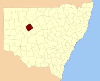
The Parish is located at 30°56′56″S144°57′15″E / 30.94889°S 144.95417°E .
The topography is flat with a Köppen climate classification of BsK (Hot semi arid). [7] The economy in the parish is based on broad acre agriculture, based on Wheat, sheep and cattle.
The traditional owners of the area are the Barkindji people. [8] [9]

The Plains Parish, New South Wales is a rural locality of Bogan Shire and a civil parish of Oxley County, New South Wales, a Cadastral divisions of New South Wales.
Terangan is a rural locality of Warren Shire and a civil parish of Oxley County, New South Wales, a Cadastral divisions of New South Wales.
Tabraton Parish, New South Wales is a rural locality of Warren Shire and a civil parish of Oxley County, New South Wales, a Cadastral divisions of New South Wales.
Mullengudgery Parish, New South Wales is a rural locality of Bogan Shire and a civil parish of Oxley County, New South Wales, Cadastral divisions of New South Wales.
Dooran Parish, New South Wales is a rural locality of Warren Shire and a civil parish of Oxley County, New South Wales, a Cadastral divisions of New South Wales.
Donalroe Parish in Cobar Shire is a civil parish of Rankin County,; a Cadastral division of New South Wales.
Budda Parish in Cobar Shire is a civil parish of Rankin County,; a Cadastral division of New South Wales.
Tankarrok Parish in Cobar Shire is a civil parish of Rankin County,; a Cadastral division of New South Wales.
Buckinbe Parish in Cobar Shire is a civil parish of Rankin County,; a Cadastral division of New South Wales.
Wallandra Parish in Cobar Shire is a civil parish of Rankin County, a Cadastral division of New South Wales. The Parish is on the Darling River upstream of Wilcannia, New South Wales and is located at 30.5511°N 144.3351°E. The only town of the parish is Tilpa, New South Wales.
Cumbedore Parish, Yanda County in Bourke Shire is a civil parish of Yanda County, a cadasteral division of New South Wales.
Canpadore Parish, Yanda County in Bourke Shire is a civil parish of Yanda County, a cadasteral division of New South Wales; a Cadastral division of New South Wales.
Bright Parish, in Cobar Shire is a civil parish of Yanda County, a Cadastral division of New South Wales.
Kenindee Parish, in Cobar Shire is a civil parish of Yanda County a Cadastral division of New South Wales.
Kenindee Parish, in Cobar Shire is a civil parish of Yanda County a Cadastral division of New South Wales.
Emu Parish, in Cobar Shire is a civil parish of Yanda County a Cadastral division of New South Wales.

Dunlop Parish is a civil parish, of Yanda County, a cadasteral division of New South Wales; a Cadastral division of New South Wales.
Gundabooka Parish is a civil parish, of Yanda County, a cadasteral division of New South Wales; a Cadastral division of New South Wales.
Yanda Parish, is a civil parish, of Yanda County, a cadasteral division of New South Wales; a Cadastral division of New South Wales.
Loftus Parish is a civil parish of Cowper County, New South Wales; a Cadastral division of New South Wales. located at 30°13'05.0"S 146°27'57.0"E between Byrock, New South Wales and Bourke, New South Wales.
| | This Central West geography article is a stub. You can help Wikipedia by expanding it. |