
The Axel Heiberg Glacier in Antarctica is a valley glacier, 30 nautical miles long, descending from the high elevations of the Antarctic Plateau into the Ross Ice Shelf between the Herbert Range and Mount Don Pedro Christophersen in the Queen Maud Mountains.

Shackleton Glacier is a major Antarctic glacier, over 60 nautical miles long and from 5 to 10 nautical miles wide, descending from the Antarctic Plateau from the vicinity of Roberts Massif and flowing north through the Queen Maud Mountains to enter the Ross Ice Shelf between Mount Speed and Waldron Spurs. Discovered by the United States Antarctic Service (USAS) (1939–41) and named by the Advisory Committee on Antarctic Names (US-ACAN) for Sir Ernest Shackleton, British Antarctic explorer.
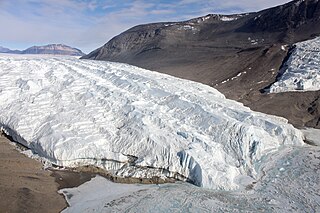
The Taylor Glacier is a glacier in Antarctica about 35 nautical miles long, flowing from the plateau of Victoria Land into the western end of Taylor Valley, north of the Kukri Hills. It flows to the south of the Asgard Range. The middle part of the glacier is bounded on the north by the Inland Forts and on the south by Beacon Valley.
Irvine Glacier is a glacier, 40 miles (64 km) long, draining southeast between the Guettard Range and the Rare Range into the northern part of Gardner Inlet, Antarctica. It was discovered by the Ronne Antarctic Research Expedition (RARE), 1947–48, under Finn Ronne, who named it for George J. Irvine, of the Engineer Depot at Fort Belvoir, Virginia, who outlined the RARE photographic program.

Olavarría Partido is a partido in the central region of Buenos Aires Province in Argentina.
The Allan Hills are a group of hills, mainly ice free and about 12 nautical miles long, lying just north-west of the Coombs Hills near the heads of Mawson Glacier and Mackay Glacier in the Oates Land and Victoria Land regions of Antarctica.
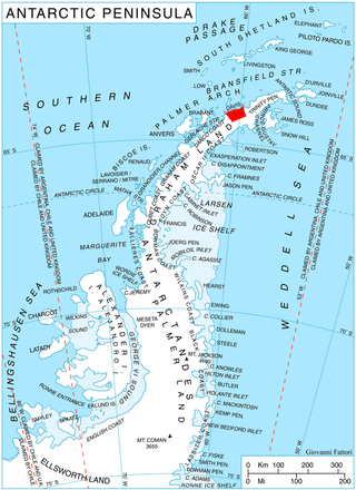
Sabine Glacier is a 13.5 km long glacier on the north side of Detroit Plateau, flowing from Mount Bris and Tsarevets Buttress northwards along the east slopes of Korten Ridge, and terminating at the sea in Jordanoff Bay on Davis Coast in Graham Land, Antarctica. Captain Henry Foster gave the name "Cape Sabine" in 1829 to a feature lying southeast of Cape Kater but it has not been possible to identify that cape. This toponym preserves the early use of Sabine in this area. Sir Edward Sabine (1788-1883), English astronomer and geodesist, was a member of the committee which planned the 1829 voyage of Foster in the Chanticleer.
Andranomanelatra is a town and commune in Madagascar. It belongs to the district of Antsirabe II, which is a part of Vakinankaratra Region. The population of the commune was estimated to be approximately 30,000 in 2001 commune census.
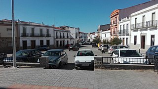
Valle de la Serena is a Spanish municipality in the province of Badajoz, Extremadura. It has a population of 1,457 (2007) and an area of 121.4 km2.
Cafeara is a municipality in the state of Paraná in the Southern Region of Brazil. It is located approximately 100 km to the north-west of Londrina.
Agustoni is a village and rural locality (municipality) in La Pampa Province in Argentina.
Bevin Glacier is a glacier 5 nautical miles (9 km) long, which flows east from the plateau escarpment on the east side of Graham Land into the northwest end of Cabinet Inlet between Attlee Glacier and Anderson Glacier. During December 1947 it was charted by the Falkland Islands Dependencies Survey (FIDS) and photographed from the air by the Ronne Antarctic Research Expedition. It was named by the FIDS for Rt. Hon. Ernest Bevin, M.P., British Minister of Labour and National Service and member of the War Cabinet.
The Brown Hills are a group of mainly snow-free hills in the Cook Mountains of Antarctica.

Cadman Glacier is a glacier, 1.5 nautical miles (3 km) wide at its mouth and about 7 nautical miles (13 km) long, flowing northwestward into the head of the southern arm of Beascochea Bay south of Plas Point on the west side of the Antarctic Peninsula.
Mount Wyss is a peak in Antarctica. It is 1,930 m high, standing 3 nautical miles east of Mount Rotoiti in the Frigate Range. Mapped by the United States Geological Survey (USGS) from tellurometer surveys and Navy air photos, 1960–62. Named by Advisory Committee on Antarctic Names (US-ACAN) for Orville Wyss, United States Antarctic Research Program (USARP) biologist at McMurdo Station, 1962–63.
Channel Glacier is a through glacier, 1.5 nautical miles (3 km), extending in an east-west direction across Wiencke Island, between Nipple Peak and Wall Range, in the Palmer Archipelago. It was discovered by the Belgian Antarctic Expedition under Gerlache 1897–99. The name appears on a chart based on a 1927 survey by DI personnel on the Discovery.
Crosse Passage is a small passage leading southeast from Adelaide Anchorage between the Henkes Islands and the Skeen Rocks, off the south end of Adelaide Island. It was named by the UK Antarctic Place-Names Committee in 1963 for Lieutenant Commander Anthony G. Crosse, Royal Navy, First Lieutenant of HMS Protector which was used by the Hydrographic Survey Unit in charting this area in 1961–63.

Kukri Hills is a prominent east-west trending range, about 25 nautical miles (46 km) long and over 2,000 metres (6,600 ft) high, forming the divide between Ferrar Glacier on the south and Taylor Glacier and Taylor Valley on the north, in Victoria Land, Antarctica.
The Havola Escarpment is an isolated, snow-covered escarpment about 30 nautical miles northwest of the Thiel Mountains in Antarctica. The escarpment is arc shaped, 30 nautical miles, and faces south.