Related Research Articles

The Orange River is a river in Southern Africa. It is the longest river in South Africa. With a total length of 2,432 km (1,511 mi), the Orange River Basin extends from Lesotho into South Africa and Namibia to the north. It rises in the Drakensberg mountains in Lesotho, flowing westwards through South Africa to the Atlantic Ocean. The river forms part of the international borders between South Africa and Lesotho and between South Africa and Namibia, as well as several provincial borders within South Africa. Except for Upington, it does not pass through any major cities. The Orange River plays an important role in the South African economy by providing water for irrigation and hydroelectric power. The river was named the Orange River in honour of the Dutch ruling family, the House of Orange, by the Dutch explorer Robert Jacob Gordon. Other names include simply the word for river, in Khoekhoegowab orthography written as !Garib, which is rendered in Afrikaans as Gariep River with the intrusion of a velar fricative in place of the alveolar click, Groote River or Senqu River, derived from ǂNū "Black". It is known in isiZulu as isAngqu.
Dore is a large village in the Sheffield district, in the county of South Yorkshire, England. The village lies on a hill above the River Sheaf which gave Sheffield its name and, until 1934, was part of Derbyshire but it is now a suburb of the city.

Luz is a Brazilian municipality located in the West part of the state of Minas Gerais. Luz is located between the city of Araxá and the capital city of the state of Minas Gerais, Belo Horizonte. The population is 18,257 in an area of 1172 km2. The city belongs to the Central Mineira region and to the micro-region of Bom Despacho. It became a municipality in 1923.
The Olifants River is a river in the northwestern area of the Western Cape Province of South Africa. The upper and main catchment area of the Olifants river is around Ceres and the Cederberg mountains. The Clanwilliam and Bulshoek dams are located on the river and provide water for the towns and farms along the watercourse. The river is approximately 285 km long with a catchment area of 46,220 km2. It flows into the Atlantic Ocean at Papendorp, 250 km north of Cape Town.

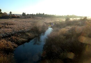
The Berg River is a river located just north of Cape Town in the Western Cape Province of South Africa. It is approximately 294 km (183 mi) long with a catchment area of 7,715 km2 (2,979 sq mi) and empties into the Atlantic Ocean. About 65% of the Berg River area is under agriculture. The major towns in the Berg River area are Velddrif and Laaiplek near the coast, and Piketberg, Hopefield, Moorreesburg and Darling further inland.

The Gariep Dam is located in South Africa, near the town of Norvalspont, bordering the Free State and Eastern Cape provinces. Its primary purpose is for irrigation, domestic and industrial use as well as for power generation. It the largest dam in South Africa.
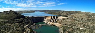
The Vanderkloof Dam is situated approximately 130 km (81 mi) downstream from Gariep Dam and is fed by the Orange River, South Africa's largest river. Vanderkloof Dam is the second-largest dam in South Africa, having the highest dam wall in the country at 108 metres (354 ft). The dam was commissioned in 1977; it has a capacity of 3,187.557 million cubic metres (2,584,195 acre⋅ft) and a surface area of 133.43 square kilometres (51.52 sq mi) when full. Other rivers flowing into this dam are the Berg River, two unnamed streams coming in from the direction of Reebokrand, the Knapsak River, Paaiskloofspruit, Seekoei River, Kattegatspruit and the Hondeblaf River, in a clockwise direction.

The Steenbras Dam, now referred to as Steenbras Lower Dam, is a gravity concrete arch type dam located in the Hottentots-Holland mountains, above Gordons Bay, near Cape Town in South Africa. It is one of the six large dams that make up the Western Cape Water Supply System. It is owned by the City of Cape Town and serves principally to supply water to that city. The dam wall is 28 metres (92 ft) high and 412 metres (1,352 ft) long; it impounds a reservoir of 36,133 megalitres over a surface area of 380 hectares when full.

The Berg River Dam is a 68-metre (223 ft) high dam on the Berg River in South Africa. It is the centerpiece of the Berg Water Project (BWP) which is designed to capture the winter rainfall and store it for supply to Cape Town during the dry summer months. The project in turn forms an important part of the Western Cape Water Supply System (WCWSS), an intricate system of dams and bulk water infrastructure that provides water to more than 3 million people. At the inauguration of the dam in 2009, then President of South Africa Kgalema Motlanthe called the project "a good example of how public infrastructure projects can be used to contribute meaningfully to poverty eradication and to foster social empowerment of the people." The Berg River Dam was the first dam in South Africa to be designed and constructed in accordance with the guidelines of the World Commission on Dams. It has been completed on time and within budget. The Berg River basin and the adjacent metropolitan area of Cape Town are of particular importance to the Western Cape region because, although the basin generates only about 3% of the country's water resources, it is home to about 8% of South Africa's population, and produces about 12% of GDP.

Woodhead Dam is a dam on Table Mountain, Western Cape, South Africa. It was built in 1897 and supplies water to Cape Town. The dam, which was the first large masonry dam in South Africa, was designated as an International Historic Civil Engineering Landmark by the American Society of Civil Engineers in 2008.
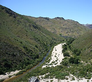
The Groot River is a river in the Western Cape Province, South Africa. It is part of the Olifants/Doring River system. It is not to be confused with the Groot River of Eastern Cape or the Groot River of Southern Cape provinces.

The Braamfontein Spruit is the longest stream in Johannesburg, South Africa.
The Doring River is a river in the Western Cape Province, South Africa. It is part of the Olifants/Doring River system.

The Crocodile River is a river in South Africa. At its confluence with the Marico River, the Limpopo River is formed.
The Wilge River (iKuthu) is a river in Mpumalanga and Gauteng provinces, South Africa. It is a tributary of the Olifants River.
The Vaal River Barrage Reservoir is a dam on the Vaal River near Vanderbijlpark, border Gauteng and Free State, South Africa.

The Dordogne is a river in south-central and southwest France. It is 483.1 km (300.2 mi) long. The Dordogne and its watershed were designated Biosphere Reserve by UNESCO on 11 July 2012.
References
This article about a dam or floodgate in South Africa is a stub. You can help Wikipedia by expanding it. |