
Amalfi is a town and comune in the province of Salerno, in the region of Campania, Italy, on the Gulf of Salerno. It lies at the mouth of a deep ravine, at the foot of Monte Cerreto, surrounded by dramatic cliffs and coastal scenery. The town of Amalfi was the capital of the maritime republic known as the Duchy of Amalfi, an important trading power in the Mediterranean between 839 and around 1200.
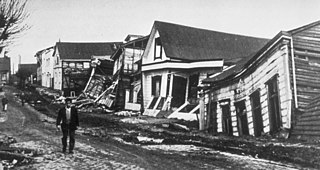
The 1960 Valdivia earthquake and tsunami or the Great Chilean earthquake occurred on 22 May 1960. Most studies have placed it at 9.4–9.6 on the moment magnitude scale, while some studies have placed the magnitude lower than 9.4. This makes it the most powerful earthquake ever recorded. It occurred in the afternoon, and lasted 10 minutes. The resulting tsunamis affected southern Chile, Hawaii, Japan, the Philippines, eastern New Zealand, southeast Australia, and the Aleutian Islands.

The Nepean River, is a major perennial river, located in the south-west and west of Sydney, New South Wales, Australia. The Nepean River, and, continuing by its downstream name, the Hawkesbury River, almost encircles the metropolitan region of Sydney.

The Amalfi Coast is a stretch of coastline in southern Italy overlooking the Tyrrhenian Sea and the Gulf of Salerno. It is located south of the Sorrentine Peninsula and north of the Cilentan Coast.
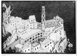
Atrani, Coast of Amalfi is a lithograph print by the Dutch artist M. C. Escher, first printed in August 1931. Atrani is a small town and commune on the Amalfi Coast in the province of Salerno in the Campania region of south-western Italy. Atrani is the second smallest town in Italy and was built right at the edge of the sea. This image of Atrani recurs several times in Escher's work, most notably in his series of Metamorphosis prints: Metamorphosis I, II and III.
Metamorphosis I is a woodcut print by the Dutch artist M. C. Escher which was first printed in May, 1937. This piece measures 19.5 cm × 90.8 cm and is printed on two sheets.

Hurricane Francelia was the deadliest hurricane of the 1969 Atlantic hurricane season after causing significant flooding to Central America, especially Belize and Guatemala. The sixth named storm and fourth hurricane of the season, Francelia developed from a tropical wave in the southeastern Caribbean Sea on August 29. It moved west-northwestward and strengthened into a tropical storm on the following day. On September 1, Francelia reached hurricane status, shortly before re-curving west-southwest. While approaching Central America, the storm intensified and peaked as a 100 mph (160 km/h) Category 2 hurricane on September 2. Francelia weakened slightly before making landfall near Punta Gorda, Belize late on September 3. The storm quickly weakened inland and dissipated by the following day.

Amalfi is a town and municipality of the Colombian Andes, northern part of the Central Mountain Range in the Antioquia Department and part of the subregion of Northeastern Antioquia. The territory of Amalfi is bordered by the municipalities of Anorí and Segovia at its north; Segovia, Remedios and Vegachí at the east; Vegachí, Yalí, Yolombó and Gómez Plata at the south and Anorí and Guadalupe at the west. The town is served by Amalfi Airport.

The Duchy of Amalfi or the Republic of Amalfi was a de facto independent state centered on the Southern Italian city of Amalfi during the 10th and 11th centuries. The city and its territory were originally part of the larger ducatus Neapolitanus, governed by a patrician, but it extracted itself from Byzantine vassalage and first elected a duke in 958.

Atrani is a city and comune on the Amalfi Coast in the province of Salerno in the Campania region of south-western Italy. It is located to the east of Amalfi, several minutes' drive down the coast.
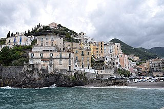
Minori is a comune in the province of Salerno, in the Campania region of south-western Italy. As a part of the Amalfi Coast, it was declared a UNESCO World Heritage Site in 1997.
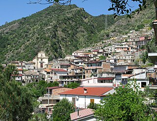
San Luca is a comune (municipality) in the Province of Reggio Calabria in Italy, located about 100 kilometres (62 mi) southwest of Catanzaro and about 35 kilometres (22 mi) east of Reggio Calabria. The town is situated on the eastern slopes of the Aspromonte mountains and in the valley of the Bonamico river. The village has long been known as a stronghold of the 'Ndrangheta, a Mafia-type criminal organisation based in Calabria, with an ongoing clan based power struggle dubbed the San Luca feud.

A series of large floods occurred in parts of the United Kingdom during the summer of 2007. The worst of the flooding occurred across parts of Northern Ireland and Scotland on 14 June; East Yorkshire and the Midlands on 15 June; Yorkshire, the Midlands, Gloucestershire, Herefordshire and Worcestershire on 25 June; and Gloucestershire, Herefordshire, Worcestershire, Oxfordshire, Berkshire and South Wales on 28 July 2007.

Tangjiashan Lake is a landslide dam-created lake on the Jian River, which was formed by the 2008 Sichuan earthquake. Its name comes from the nearby mountain Tangjiashan. On May 24, 2008, the water level rose by 2 metres in a single day, reaching a depth of 23 metres (75 ft), just 29 metres (95 ft) below the barrier level. On June 9, 2008, more than 250,000 people had been evacuated from Mianyang in anticipation of the Tangjiashan Lake dam bursting.

The 2010 China floods began in early May 2010. Three hundred and ninety-two people died, and a further 232 people were reported missing as of June 30, 2010, including 57 people in a landslide in Guizhou. Fifty-three of the deaths occurred from the flooding and landslides between May 31 and June 3, and 266 deaths occurred between June 13 and June 29. Four hundred and twenty four people were killed by the end of June, including 42 from the Guizhou landslide; 277 more were killed and 147 were missing in the first two weeks of July, bringing the death toll as of August 5 to 1,072. A landslide in early August in Gansu killed at least 1,471 people and left 294 missing. In total, the flooding and landslides killed at least 3,185 people in China by August 31. More than 230 million people in 28 provinces, municipalities, and regions, especially the southern and central provinces and regions of Zhejiang, Fujian, Jiangxi, Hubei, Hunan, Guangdong, Guangxi, Chongqing Municipality, Gansu, Sichuan, and Guizhou, and the northeastern province of Jilin were affected, while at least 4.66 million people were evacuated because of the risk of flooding and landslides in the latter half of June. By early August, over 12 million people were evacuated, and that number rose to 15.2 million by August 31.
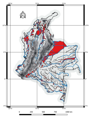
The 2010 Colombian rainy season was an unusually heavy wet season that affected Colombia during the second semester of 2010. The continuous rainfalls in combination with unstable grounds and dwellings located in high risk zones contributed to the widespread damages. The flooding and associated landslides killed 174 persons, left 225 wounded and 19 others missing. 1.5 million were left homeless.

The 1985 Puerto Rico floods produced showers and thunderstorms across the island and the deadliest single landslide on record in North America, that killed at least 130 people in the Mameyes neighborhood of barrio Portugués Urbano in Ponce. The floods were the result of a westward-moving tropical wave that emerged off the coast of Africa on September 29. The system moved into the Caribbean Sea on October 5 and produced heavy rains across Puerto Rico, peaking at 31.67 in (804 mm) in Toro Negro State Forest. Two stations broke their 24-hour rainfall records set in 1899. The rains caused severe flooding in the southern half of Puerto Rico, which isolated towns, washed out roads, and caused rivers to exceed their banks. In addition to the deadly landslide in Mameyes, the floods washed out a bridge in Santa Isabel that killed several people. The storm system caused about $125 million in damage and 180 deaths, which prompted a presidential disaster declaration. The tropical wave later spawned Tropical Storm Isabel.

Storm Desmond was an extratropical cyclone and fourth named storm of the 2015–16 UK and Ireland windstorm season, notable for directing a plume of moist air, known as an atmospheric river, which brought record amounts of orographic rainfall to upland areas of northern Atlantic Europe and subsequent major floods.


