Related Research Articles
Warren County is a county located in the south central portion of the U.S. state of Kentucky. As of the 2020 census, the population was 134,554, making it the fifth-most populous county in Kentucky. The county seat is Bowling Green. Warren County is now classified as a wet county after voters approved the measure in 2018. The measure became law in January 2019 that allows alcohol to be sold county wide.

The Kentucky River is a tributary of the Ohio River in Kentucky, United States. The 260-mile (420 km) river and its tributaries drain much of eastern and central Kentucky, passing through the Eastern Coalfield, the Cumberland Mountains, and the Bluegrass region. Its watershed encompasses about 7,000 square miles (18,000 km2), and it supplies drinking water to about one-sixth of the population of the state.
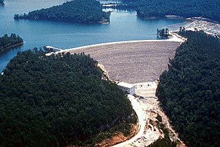
The Dix River is a 79.3-mile-long (127.6 km) tributary of the Kentucky River in central Kentucky in the United States. It begins in western Rockcastle County, about 5 miles (8 km) west of Mount Vernon. It flows generally northwest, in a tight meandering course, passing north of Stanford and east of Danville. Northeast of Danville it is impounded by the Dix Dam to form the Herrington Lake reservoir. The river flows about 2 miles (3 km) before joining the Kentucky River near High Bridge, about 20 miles (32 km) southwest of Lexington, in the region of the Kentucky River Palisades.
The Obey River is a 47.8-mile-long (76.9 km) tributary of the Cumberland River in the U.S. state of Tennessee. It joins the Cumberland River near the town of Celina, which is generally considered to be the Cumberland's head of navigation. Via the Cumberland and Ohio rivers, the Obey River is part of the Mississippi River watershed.
The Mud River is a tributary of the Green River in western Kentucky in the United States. Via the Green and Ohio rivers, it is part of the Mississippi River watershed. It is about 70.9 miles (114.1 km) long.
The Lamine River is a 63.8-mile-long (102.7 km) tributary of the Missouri River in central Missouri in the United States. It is formed in northern Morgan County, about 4 miles (6 km) southeast of Otterville by the confluence of Flat and Richland creeks, and flows generally northwardly through Cooper and Pettis counties. In northwestern Cooper County the Lamine collects the Blackwater River and flows into the Missouri River northeast of Lamine and 6 miles (10 km) west of Boonville. At Clifton City, the river has a mean annual discharge of 455 cubic feet per second. Below the mouth of the Blackwater River, its discharge averages 1,279 cubic feet per second

The Nolin River is a 104-mile-long (167 km) tributary of the Green River in central Kentucky in the United States. Via the Green and Ohio rivers, it is a part of the watershed of the Mississippi River.

The Beaver River is an intermittent river, 280 miles (450 km) long, in western Oklahoma and northern Texas in the United States. It is a tributary of the North Canadian River, draining an area of 11,690 square miles (30,300 km2) in a watershed that extends to northeastern New Mexico and includes most of the Oklahoma Panhandle.

The North Fork River or the North Fork of White River is a 109-mile-long (175 km) tributary of the White River, into which it flows near Norfork, Arkansas.

Oil Creek is a 46.7-mile (75.2 km) tributary of the Allegheny River that is located in Venango and Crawford counties in the Commonwealth of Pennsylvania in the United States.

The Barren River is a 135-mile-long (217 km) river in Southcentral Kentucky, United States, and a tributary of the Green River. The watershed of the Green River is the largest of the twelve major river watersheds in Kentucky. The Barren River rises near the Tennessee border in Monroe County and flows into the Green in northeast Warren County. The drainage basin consists of Southcentral Kentucky and north-central Tennessee.

Salt Creek is a stream in the southern part of the U.S. state of Indiana. A tributary of the East Fork of the White River, the creek begins in southwestern Bartholomew County, flows through southern parts of Brown and Monroe counties, and meets the White River just downstream from Bedford in Lawrence County. In far southwestern Brown County and much of southern Monroe County, the creek flows through Monroe Lake, which was created by damming the creek in 1965.
The Clear Fork is a 42.8-mile-long (68.9 km) tributary of the Cumberland River in Kentucky and Tennessee. By the Cumberland and Ohio rivers, it is part of the Mississippi River watershed.
The Clover Fork is a 30-mile (48 km) tributary of the Cumberland River, draining a section of the Appalachian Mountains in Harlan County, southeast Kentucky in the United States. The river's confluence with the Martin's Fork at Harlan marks the official beginning of the Cumberland River.

The Poor Fork is a 45-mile (72 km) tributary of the Cumberland River in Letcher and Harlan Counties, southeast Kentucky, in the United States. The river flows from its source at Flat Gap in Letcher County, on the Kentucky–Virginia border, generally southwest to where it meets Martin's Fork in Baxter to form the Cumberland River.
The Laurel River is a 42-mile (68 km) tributary of the Cumberland River in southeast Kentucky in the United States. The river drains a rural region in the foothills of the Appalachian Mountains, in parts of Whitley and Laurel Counties. The town of Corbin is located on the river about 15 miles (24 km) east of its mouth on the Cumberland, and near the confluence with a major tributary, the Little Laurel River.
Moreau River is a stream in Cole County in the U.S. state of Missouri. It is a tributary of the Missouri River.
Medicine Creek is a stream in Grundy, Livingston, Putnam, and Sullivan counties of the U.S. state of Missouri. It is a tributary to the Grand River.
Indian Creek is a stream in Newton and McDonald counties of southwest Missouri. It is a tributary of the Elk River.
Bull Creek is a stream in Christian and Taney counties in the Ozarks of southern Missouri.
References
- ↑ U.S. Geological Survey Geographic Names Information System: Drakes Creek (Barren River tributary)
- ↑ "USGS Surface Water data for Kentucky: USGS Surface-Water Annual Statistics".
- ↑ "Grave of "first white child born in Southern Kentucky" is in family cemetery east of city". Park City Daily News. December 4, 1955. p. 7. Retrieved 31 May 2015.
- ↑ Paterwic, Stephen J. (2009). The A to Z of the Shakers. Lanham, Maryland: Scarecrow Press. p. 202. ISBN 978-0-8108-7056-7.
36°58′50″N86°22′03″W / 36.9805982°N 86.3674893°W
| | This Warren County, Kentucky state location article is a stub. You can help Wikipedia by expanding it. |