
Readington Township is a township located in the easternmost portion of Hunterdon County, New Jersey, United States. As of the 2010 United States Census, the township's population was 16,126, reflecting an increase of 323 (+2.0%) from the 15,803 counted in the 2000 Census, which had in turn increased by 2,403 (+17.9%) from the 13,400 counted in the 1990 Census.
The South Branch Raritan River is a 50-mile-long (80 km) tributary of the Raritan River in central New Jersey in the United States.

Stony Brook, also known as Stoney Brook, is a tributary of the Millstone River in Hunterdon and Mercer counties, New Jersey, in the United States.

The Millstone River is a 38.6-mile-long (62.1 km) tributary of the Raritan River in central New Jersey in the United States.

Whitehouse is an unincorporated community located within Readington Township in Hunterdon County, New Jersey, United States. The community lies along the Jersey Turnpike, just west of Mechanicsville.
Peters Brook is a tributary of the Raritan River that flows south through Bridgewater Township and Somerville, New Jersey, in the United States. Some of its tributaries include Ross Brook and Mac's Brook.
Old York Road is a roadway that was built in the 18th century to connect Philadelphia with New York City. Through New Jersey it was built along the Raritan "Naraticong Trail", also known as the Tuckaraming Trail. A memorial plaque to the friendship of the Naraticong Indians, who permitted the road to be built over their trail, sits at the intersection of Old York Road and Canal in Raritan, NJ. The Swift Sure Stage Coach Line completed the journey between the two cities in two days and cost only a few dollars.
Clapboard Creek is a tributary of Matawan Creek in Monmouth County, New Jersey in the United States.
Stone Creek is a tributary of Holland Brook in Hunterdon County, New Jersey in the United States.
Readington Village is an unincorporated community located within Readington Township in Hunterdon County, New Jersey, United States, that is centered on the converging of Readington Road, Hillcrest Road, Centerville Road and Brookview Road. It is located on Holland Brook, originally named Amanmechunk, which means large creek in the Unami dialect. The area was inhabited by the Raritan prior to the arrival of European settlers. The Native Americans who lived near Readington Village travelled to the coast during the summer for fish and clams. Such a trip is mentioned in an Indian deed transferring lands around Holland Brook to English and Dutch settlers. The deed mentions two of the natives, who lived at Readington: Metamisco and Wataminian.

Stanton is an unincorporated community located within Readington Township in Hunterdon County, New Jersey, United States. The community dates back to the 17th century and was settled by the Dutch. It was originally called Housel's after Johannes Housel, who had a farmstead along Dreahook Road in the mid-18th century. After the death of William Housel, the last owner of the Housel farmstead, it then carried the name of Waggoner's Hill after landowner William Waggoner. The community took the descriptive name of Mount Pleasant during the beginning of the 20th century and would finally become known as Stanton to distinguish it from another Mount Pleasant. The name "Stanton" was taken from James Logan's Pennsylvania estate: Stenton, which in turn is named for the Scottish village where his father was born. Logan was a proprietor of West Jersey, a mayor of Philadelphia, and a Chief Justice of the Supreme Court of Pennsylvania. Logan Way in Readington is named after him, as well as Logan Circle and the Logan neighborhood in Philadelphia and Logan Township in Clinton County, Pennsylvania. In the 1830s, a Reformed Church and a general store were built, both of which are present today.

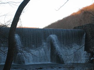
Dreahook is an unincorporated community in Readington Township in Hunterdon County, New Jersey, United States at the intersection of CR-620/Dreahook Rd and CR 523. The name is a corruption of Driehoek, which is the Dutch word for triangle. It was likely named for the triangle created by the settlement in its relation to the early roads to Flemington, Whitehouse Station, Readington Village and Pleasant Run, which have sense been rerouted. Dreahook Creek and Holland Brook both pass through the area of the former village. Dreahook village once had blacksmith shop, a school and a store. Settlers farmed the land here because of the rich soil along the base of Cushetunk Mountain. There are still numerous farms in the area, including the Readington River Buffalo Farm between Dreahook and Stanton.

Pleasant Run was a hamlet in Readington Township, Hunterdon County, New Jersey, United States. Located along Campbell's Brook, the hamlet consisted of farms, a schoolhouse and a general store. The brook was named after John Campbell, who purchased the land around it in 1685.
Barley Sheaf was an unincorporated community located within Readington Township in Hunterdon County, New Jersey, United States. It was named for the grain once grown in the region. The hamlet was on Barley Sheaf Road between County Route 629 (CR 629) and CR 523. The hamlet at one time housed a general store, a post office, blacksmith, creamery, a hotel and numerous farmsteads. Today only farms remain of the hamlet. The hamlet also carried the names of Farmersville and Campbellsville after Catherine Campbell, who ran the hotel in the area.

Peters Brook is a tributary of Stony Brook in Mercer and Hunterdon counties, New Jersey in the United States.
Beaverdam Brook is a tributary of Lawrence Brook in central East Brunswick, New Jersey in the United States.

Black Brook is a tributary of the Passaic River that flows through the Great Swamp National Wildlife Refuge in Morris County, New Jersey, in the United States. Black Brook rises at the north east base of Long Hill, Chatham Township, Morris County, flows westerly along the hill, by a course of 7 or 8 miles to its recipient in Morris Township, New Jersey. Due to the chemical fertilizer usage in nearby areas, Black Brook has the second worst water quality after Loantaka Brook.

Centerville was a hamlet within Readington Township in Hunterdon County, New Jersey, United States. The community was located along Campbell's Brook and Old York Road. Centerville grew up because of a tavern that marked the halfway point on the long Swift Sure Stage Line route from New York to Philadelphia. The hamlet had a school, a store, a post office, a church and blacksmith. When the railroads and newer roads were built, Centerville saw few visitors and today all the buildings there are residences.

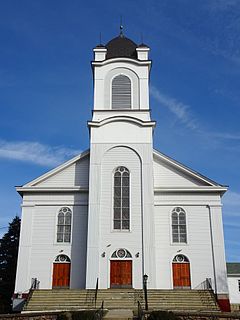
The Readington Reformed Church is a historic church located at 124 Readington Road, Readington Village, an unincorporated community located within Readington Township in Hunterdon County, New Jersey. It was known in colonial times as the Dutch Reformed Church of North Branch. It is the oldest Dutch Reformed Church in the county. The current building was built in 1865. The churchyard is known as the Readington Reformed Church Cemetery. The church was added as a contributing property of the Readington Village Historic District by the National Register of Historic Places on June 24, 1991.


