
The Mishmi people are an ethnic group of Tibet and Arunachal Pradesh, India. The area is known as the Mishmi Hills. Only one group, called the Deng, occupy Zayu County in southern Tibet.

Dibang Valley (Pron:/dɪˈbæŋ/) is a district of Arunachal Pradesh named after the Dibang River or the Talon as the Mishmis call it. It is the least populated district in India and has an area of 9,129 square kilometres (3,525 sq mi).
The Abor Hills is a region of Arunachal Pradesh in the far northeast of India, near the border with China. The hills are bordered by the Mishmi Hills and Miri Hills, and drained by the Dibang River, a tributary of the Brahmaputra.
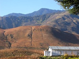
Anini is the headquarters of the Dibang Valley district in the state of Arunachal Pradesh in Northeast India. Anini was also the district headquarters of the undivided Dibang Valley district. Most of this location's population consists of the Idu Mishmi tribal people. Due to its remote location, Anini remains a small and underdeveloped town. However, it still has basic road and air links to the rest of India. The town is fully dependent on the nearest major settlement, Roing, which is in the Lower Dibang Valley District, for most commercial needs.
Mouling National Park is a national park located in the Indian state of Arunachal Pradesh, spread primarily over the Upper Siang district and parts of the West Siang and East Siang district. It was the second national park to be created in the state, after Namdapha National Park in 1972. The Mouling National Park and the Dibang Wildlife Sanctuary are located fully or partly within Dihang-Dibang Biosphere Reserve.
Padam is a sub-tribe of the Adi tribe of Abotani clan which speaks one of the Sino-Tibetan languages. Padam makes up 30–35% of the Adis and are the strongest sub-tribe of the Adis. They were a nomadic warrior race and used to had a reputation as fierce warrior by pre colonial period, they are believed to have migrated to present Arunachal Pradesh from Tibet. They were also known by the name Bor Abors in the past by their Assam counterparts and the British government.

Roing is the district headquarter of Lower Dibang Valley district in the Indian state of Arunachal Pradesh. It is the last major township at the north-eastern frontier of India.
Dihang-Dibang or Dehang-Debang is a biosphere reserve constituted in 1998. It is in the Indian state of Arunachal Pradesh. The Mouling National Park and the Dibang Wildlife Sanctuary are located fully or partly within this biosphere reserve. The reserve spreads over three districts: Dibang Valley, Upper Siang, and West Siang. It covers high mountains of Eastern Himalaya and Mishmi Hills. The elevation in the reserve ranges up to more than 5,000 metres (16,000 ft) above sea level. An important fact relating to this Biosphere reserve is that it has natural vegetation stretching in an unbroken sequence from the tropics to mountain tundra. The type of vegetation are found in this biosphere reserve can be grouped as 1. Sub-tropical broad leafed forests, 2. Sub tropical pine forest, 3. Temperate broad leafed forests, 4. Temperate conifer, 5. Sub-alpine woody shrub, 6. Alpine meadow( mountain Tundra), 7. Bamboo brakes, 8. Grassland. The habitat in Dihang-Dibang ranges from tropical wet evergreen in the river gorges to subtropical, temperate, alpine and permanent snow.
Etalin is a village and the headquarters of an eponymous circle (subdistrict) in the Dibang Valley district in the Indian state of Arunachal Pradesh. It is a rest stop used by those taking the route to Anini or Malinye. Etalin is approximately 52 km from Anini and approximately 42 km from Malinye. The nearest hospital is the Anini General Hospital.There is one middle school in Etalin and for further study they have to move to Anini High secondary School or Roing High Secondary School, the nearest airport is in Assam (Mohanbari).
The Drought Research Initiative (DRI) was established to better understand the characteristics and processes influencing Canadian Prairie droughts and better predict them, focusing on the severe drought which began in 1999 and largely ended in 2005. It is an interdisciplinary effort involving 15 funded investigators from six Canadian universities, over 20 collaborators from other universities and federal laboratories, and partners from three provincial governments. The DRI focuses on five research themes: quantification, understanding, prediction, comparisons with other droughts, and implications for society. Details may be found in Stewart et al. (2008) and on the DRI website.
The Dibang Dam is a planned concrete gravity dam, located in the Lower Dibang Valley District in Arunachal Pradesh, India. If constructed, it will be India's largest dam and the world's tallest concrete gravity dam, standing 288 metres (945 ft) tall. The Dibang Dam is expected to provide up to 3,000 megawatts of hydroelectric power and will also assist with flood control in the Dibang Valley.

Dibang River, also known as Sikang by the Adi and Talo in Idu, is an upstream tributary river of the Brahmaputra in the Indian state of Arunachal Pradesh. It originates and flows through the Mishmi Hills in the (Upper) Dibang Valley and Lower Dibang Valley districts.

National Highway 13, part of the larger Trans-Arunachal Highway network, is a 1,559 km long two-lane national highway across Arunachal Pradesh in India running from Tawang in northwest to Wakro in southeast. Entire route became operational in 2018 when 6.2 km long Dibang River Bridge was completed across Dibang River. Sela Tunnel, a shorter alternative route with target completion by Jan/Feb 2022, will provide all-weather connectivity. Before the renumbering of highways, it was known as NH 229 and NH52. This strategically important highway enhances Indian military's capabilities in combating the threat of China's Western Theater Command opposite India's eastern sector of Line of Actual Control.
The Bailey–Morshead exploration of the Tsangpo Gorge was an unauthorised expedition by Frederick Bailey and Henry Morshead in 1913 which for the first time established the definite route by which the Tsangpo River reaches the sea from north of Himalaya, through the Tsangpo Gorge.

Arunachal Pradesh is primarily a hilly tract nestled in the foothills of the Himalayas in northeast India. It is spread over an area of 83,743 km2 (32,333 sq mi). 98% of the geographical area is land out of which 80% is forest cover; 2% is water. River systems in the region, including those from the higher Himalayas and Patkoi and Arakan Ranges, eventually drain into the Brahmaputra River.

The Dibang River Bridge is a beam bridge across Dibang River which connects Bomjir and Malek villages and provides all-weather connectivity between Dambuk and Roing in eastern part of Arunachal Pradesh, India. At 6.2 km long, it is the second-longest bridge above water in India and was completed in 2018 as part of NH13 Trans-Arunachal Highway. This strategically important bridge helps Indian military combat anti-national activities and Chinese military threat in the easter sector of Line of Actual Control border areas. It is known as "Sikang" in Adi Language and "Talon" in Idu Mishmi language.

Daayan is an Indian paranormal romance drama series created by Ekta Kapoor under Balaji Telefilms. It premiered on 15 December 2018 on &TV and starred Tina Datta, Mohit Malhotra and Priya Bathija.
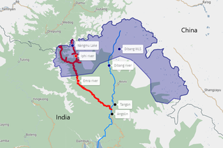
Emra River is a right-bank tributary of the Dibang River which eventually flows into the Brahmaputra River. The entire valley of the river is contained in the Etalin Circle of the Dibang Valley district.
Mipi is a village and the headquarters of the Mipi Circle in the Dibang Valley district of the Indian state of Arunachal Pradesh. Mipi HQ is located near the confluence of Andra River with the Mathun or Dibang River, and the main Mipi village, called Mipido, is 2 km to the south.