Related Research Articles

Dublin is the capital and largest city of Ireland. On a bay at the mouth of the River Liffey, it is in the province of Leinster, bordered on the south by the Dublin Mountains, a part of the Wicklow Mountains range. At the 2016 census it had a population of 1,173,179, while the preliminary results of the 2022 census recorded that County Dublin as a whole had a population of 1,450,701, and that the population of the Greater Dublin Area was over 2 million, or roughly 40% of the Republic of Ireland's total population.

Waterford is a city in County Waterford in the south-east of Ireland. It is located within the province of Munster. The city is situated at the head of Waterford Harbour. It is the oldest and the fifth most populous city in the Republic of Ireland. It is the ninth most populous settlement on the island of Ireland. Waterford City and County Council is the local government authority for the city. According to the 2016 Census, 53,504 people live in the city, with a wider metropolitan population of 82,963.

Swords, the county town of Fingal, is a large suburban town on the east coast of Ireland, situated ten kilometres north of Dublin city centre. The town was reputedly founded c. AD 560. Located on the Ward River, Swords features Swords Castle, a restored medieval castle, a holy well from which it takes its name, a round tower and a Norman tower. Facilities in the area include the Pavilions shopping centre, one of the largest in the Dublin region, a range of civic offices, some light industries, the main storage facility and archive of the National Museum of Ireland and several parks. Dublin Airport is located nearby.

Ailesbury Road, is an tree-lined avenue in the affluent Dublin 4 area in Dublin, Ireland. It links Sydney Parade Station on Sydney Parade Avenue and the Church of the Sacred Heart at Anglesea Road, Donnybrook. Historically, many embassies and diplomatic residences have been located on the road, including the striking residence of the French Ambassador, the embassy of the People's Republic of China, and the Japanese embassy.

Coolock is a large suburban area, centred on a village, on Dublin city's Northside in Ireland. Coolock is crossed by the Santry River, a prominent feature in the middle of the district, with a linear park and ponds. The Coolock suburban area encompasses parts of three Dublin postal districts: Dublin 5, Dublin 13 and Dublin 17.
Crumlin is a village in County Antrim, Northern Ireland.
Portobello is an area of Dublin in Ireland, within the southern city centre and bounded to the south by the Grand Canal. It came into existence as a small suburb south of the city in the 18th century, centred on Richmond Street. During the following century it was completely developed, transforming an area of private estates and farmland into solid Victorian red-bricked living quarters for the middle classes on the larger streets, and terraced housing bordering the canal for the working classes.

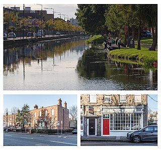
Crumlin is a Southside suburb of Dublin, Ireland. Formerly a rural area, it became heavily built up from the early 20th century onwards. Crumlin is the site of Ireland's largest children's hospital, Our Lady's Children's Hospital.

Drimnagh is a suburb in Dublin, Ireland to the south of the city between Walkinstown, Crumlin and Inchicore, bordered by the Grand Canal to the north and east. Drimnagh is in postal district Dublin 12.

Santry is a suburb on the northside of Dublin, Ireland, bordering Coolock, Glasnevin, Kilmore and Ballymun. It straddles the boundary of Dublin City Council and Fingal County Council jurisdictions.

Broadstone is one of the three neighbourhoods that make up present-day Phibsboro in Dublin, Ireland. The most southerly of these, it begins just two kilometres north of Father Mathew Bridge at Ormond Quay. The area is triangular, bounded by Phibsborough Road and Constitution Hill to the West, North Circular Road to the north, and Dorset Street and Bolton Street to the south-east. The postal district for the area is Dublin 7.

Chapelizod is a village preserved within the city of Dublin, Ireland. It lies in the wooded valley of the River Liffey, near the Strawberry Beds and the Phoenix Park. The village is associated with Iseult of Ireland and the location of Iseult's chapel. Chapelizod is under the administration of Dublin City Council.

RDS Arena is a multi-purpose sports stadium, owned by the Royal Dublin Society (RDS) and located in the Dublin suburb of Ballsbridge, Ireland.

The Ilac Centre is a shopping centre, located in central Dublin, north of the River Liffey. It has entrances opening onto Henry Street, Parnell Street and Moore Street.

Talbot Street is a city-centre street located on Dublin's Northside, near to Dublin Connolly railway station. It was laid out in the 1840s and a number of 19th-century buildings still survive. The Irish Life Mall is on the street.
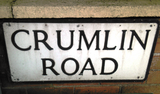
The Crumlin Road is a main road in north-west Belfast, Northern Ireland. The road runs from north of Belfast City Centre for about four miles to the outskirts of the city. It also forms part of the longer A52 road which leads out of Belfast to the town of Crumlin. The lower section of the road houses a number of historic buildings, including the city's former law courts and prison, whilst the road encompasses several large housing areas, including Ardoyne, Ballysillan and Ligoniel(from Irish: Lag an Aoil, meaning hollow of the lime)..

Kimmage, is a suburb on the south side of the city of Dublin in Ireland.

Patrick Costello is an Irish Green Party politician who has been a Teachta Dála (TD) for the Dublin South-Central constituency since the 2020 general election.

Tailors' Hall is the oldest of two surviving guildhalls in Dublin, Ireland. It is located on Back Lane, off High Street, in the part of the city known as the Liberties. Aside from meetings of its own and many other of the guilds of Dublin, the hall has hosted many social, cultural and educational events. It has been used as a court-house, a barracks, a school, a place of worship and in place of Dublin's City Hall. It was also a meeting place of the United Irishmen, and the site of the Back Lane Parliament. The Tailors' Guild having fully released it by 1873, the building hosted a Christian Mission and later the Legion of Mary. The building having become uninhabitable by the mid-20th century, the Irish Georgian Society launched a restoration campaign in 1966, and it was reopened in 1971. It now holds the headquarters of Ireland's national heritage charity, An Taisce, and can be visited, and rented for events.
References
| | This article about an organisation in Ireland is a stub. You can help Wikipedia by expanding it. |