Related Research Articles
Breed is a town in Oconto County, Wisconsin, United States. The population was 657 at the 2000 census.

Suring is a village in Oconto County, Wisconsin, United States, along the 45th parallel. The population was 544 at the 2010 census. It is part of the Green Bay Metropolitan Statistical Area.

Underhill is a town in Oconto County, Wisconsin, United States. The population was 846 at the 2000 census.

Lodi is a city in Columbia County, Wisconsin, United States. The population was 3,209 at the 2022 United States census. Lodi is part of the Madison Metropolitan Statistical Area.
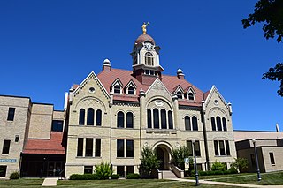
Oconto is a city and county seat of Oconto County, Wisconsin, United States. The population was 4,609 at the 2020 census. It is part of the Green Bay Metropolitan Statistical Area. The city is located partially within the town of Oconto.

The Wolf River is a 225 mi (362 km) long tributary of the Fox River in northeastern Wisconsin in the Great Lakes region of the United States. The river is one of the two National Scenic Rivers in Wisconsin, along with the St. Croix River. The scenic portion is 24 miles (39 km) long. The river and its parent the Fox River and associated lakes are known for their sturgeon which spawn every spring upstream on the lower river until blocked by the Shawano Dam. The river flows through mostly undeveloped forestland southerly from central Forest County in the north to Lake Poygan in the south. The lake is part of the Winnebago Pool of lakes fed by both the Fox and Wolf Rivers. The Fox-Wolf basin is usually considered to be a single unified basin and the rivers themselves may be referred to as the Fox-Wolf River system.
Duck Creek Township is a township in Adams County, North Dakota, United States. As of the 2010 census, its population was 24.
Sugar Bush is an unincorporated community located entirely within the town of Maple Creek in northwest Outagamie County, Wisconsin, United States. Sugar Bush is classified as a Class U6 Community by the USGS, being a populated place located wholly or substantially outside the boundaries of any incorporated place or CDP with a recognized authoritative common name.

Medina, originally Young's Corner, is an unincorporated community in the Town of Dale in southwest Outagamie County, Wisconsin, United States. It is located 3.5 miles (5.6 km) south of the village of Hortonville, 11 miles (18 km) west of Appleton, and 20 miles (32 km) northwest of Oshkosh.
The Iron River is a 17.1-mile-long (27.5 km) river in Iron County, Michigan, in the United States. It flows from northwest to southeast through the city of Iron River to the Brule River. It is part of the Menominee River watershed, flowing to Lake Michigan.
The Fox River State Recreational Trail is a trail along the Fox River in northeastern Wisconsin.

Minnesota Junction is an unincorporated community located, in the town of Oak Grove, in Dodge County, Wisconsin, United States. Minnesota Junction is located on Wisconsin Highway 26. It is located at latitude 43.452 and longitude -88.697 at 925 feet above mean sea level.
Fort Howard was a city in Brown County, Wisconsin, United States. It was first incorporated as a "borough" of 664 acres on October 13, 1856. As the result of a referendum on the union of the two cities held on April 2, 1895, the city was entirely annexed to the City of Green Bay and ceased to exist.
Birch Creek is a stream in Menominee County, Michigan, in the United States. It is a tributary of Springer Creek.
Birch Creek is an unincorporated community in Menominee County, in the U.S. state of Michigan.
Calhoun is a neighborhood of New Berlin, Waukesha County, Wisconsin, United States.
Francis Creek is a stream in Manitowoc County, Wisconsin, in the United States.
Wedges Creek is a stream in Clark County, Wisconsin, in the United States.

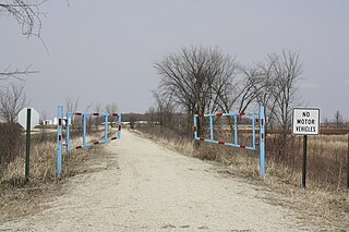
The Duck Creek Trail is a crushed limestone trail in Outagamie and Brown Counties in northeast Wisconsin. The Duck Creek Trail spans seven miles (11 km), beginning at the eastern end of the Newton Blackmour State Trail, just east of Vanderheuvel Road in Seymour. The trail continues east through the Oneida Nation of Wisconsin in northern Outagamie County paralleling State Route 54, and continues to the Village of Oneida. The Duck Creek Trail will eventually extend to Pamperin Park in Green Bay.
Moccasin Creek is a stream in the U.S. state of Wisconsin. It is a tributary to the Wisconsin River.
References
- ↑ U.S. Geological Survey Geographic Names Information System: Duck Creek (Wisconsin)
- ↑ Chicago and North Western Railway Company (1908). A History of the Origin of the Place Names Connected with the Chicago & North Western and Chicago, St. Paul, Minneapolis & Omaha Railways. p. 66.
- ↑ Hoffman, Mike. "Menominee Place Names in Wisconsin". The Menominee Clans Story. Retrieved 2018-10-06.
44°33′37″N88°01′09″W / 44.56028°N 88.01917°W
| | This article about a location in Brown County, Wisconsin is a stub. You can help Wikipedia by expanding it. |
| | This article about a location in Outagamie County, Wisconsin is a stub. You can help Wikipedia by expanding it. |
| | This article related to a river in Wisconsin is a stub. You can help Wikipedia by expanding it. |