
Howard is a village in Brown and Outagamie counties in the U.S. state of Wisconsin. The population was 19,950 at the 2020 census. It is part of the Green Bay Metropolitan Statistical Area.
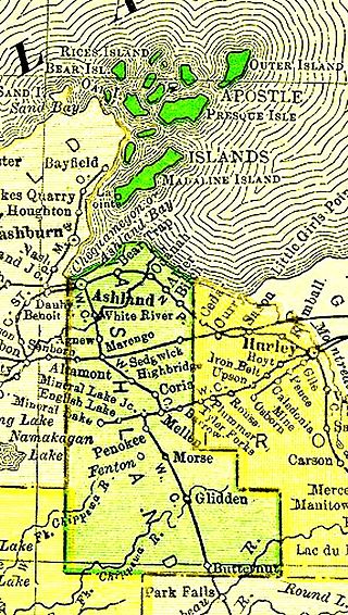
The Apostle Islands are a group of 22 islands in Lake Superior, off the Bayfield Peninsula in northern Wisconsin. The majority of the islands are located in Ashland County—only Sand, York, Eagle, and Raspberry Islands are located in Bayfield County. All the islands except for Madeline Island are part of the Apostle Islands National Lakeshore. The islands in Ashland County are all in the Town of La Pointe, except for Long Island, which is in the Town of Sanborn, while those in Bayfield County are in the Towns of Russell and Bayfield.

Gills Rock is an unincorporated community located on Highway 42 at the northern tip of the Door Peninsula in Door County, Wisconsin, United States. It is within the town of Liberty Grove and was formerly known as Hedgehog Harbor.

The Canaveral National Seashore (CANA) is a National Seashore located between New Smyrna Beach and Titusville, Florida, in Volusia and Brevard Counties. The park, located on a barrier island, was created on January 3, 1975, by an act of Congress. The park is split between Brevard and Volusia counties, with 9 miles of the seashore in Brevard County, and 15 miles of the seashore in Volusia County. CANA consists of 24 miles of beaches, dunes, mangrove wetlands, and a large portion of the Mosquito Lagoon. The Canaveral National Seashore is also the longest expanse of undeveloped land along the East Coast of Florida. The Canaveral National Seashore is home to more than 1,000 plant species and 310 bird species. CANA occupies 57,662 acres (23,335 ha). There are 3 major beach sections in the seashore. The southern section is Playalinda Beach, the middle section is Klondike Beach, and the northern section is Apollo Beach.

Verner Edward Suomi was a Finnish-American educator, inventor, and scientist. He is considered the father of satellite meteorology. He invented the Spin Scan Radiometer, which for many years was the instrument on the GOES weather satellites that generated the time sequences of cloud images seen on television weather shows. The Suomi NPP polar orbiting satellite, launched in 2011, was named in his honor.

Plum Island is an island in Lake Michigan in the southern part of the town of Washington in Door County, off the tip of the Door Peninsula in the U.S. state of Wisconsin. The uninhabited island has a land area of 1.179 square kilometres (0.455 sq mi) or 117.87 hectares. Carp Lake is located on the northwestern side. During years when Lake Michigan's water levels are high, it is a lagoon of Lake Michigan, but it gets cut off as a separate lake during low water years.

Newport State Park is a 2,373-acre (960 ha) Wisconsin state park at the tip of Door Peninsula near Europe Lake. Protecting 11 miles (18 km) of shoreline on Lake Michigan, Newport is Wisconsin's only wilderness-designated state park. The park is open year-round and can be accessed via WIS 42.

Cana Island is an island in Lake Michigan in the town of Baileys Harbor in Door County, Wisconsin, United States. The Cana Island Light is on the east side of the island. It is possible to walk to Cana Island from the mainland over the tombolo when water levels are low. Tombolo conditions are monitored by a webcam operated by the county parks department. The island is part of the Town of Baileys Harbor, Wisconsin.
Green Island is an island in Green Bay and part of the Town of Peshtigo, in Marinette County, Wisconsin. The Green Island Light is on the island.

Horseshoe Island is an island in Green Bay in Door County, Wisconsin. The island is located offshore from Peninsula State Park and is part of the state park. The French explorer Jean Nicolet reportedly landed on the island. The island is part of the Town of Gibraltar, and lies offshore from the village of Ephraim, Wisconsin.

Potawatomi State Park is a 1,225-acre (496 ha) Wisconsin state park northwest of the city of Sturgeon Bay, Wisconsin in the Town of Nasewaupee. It is located in Door County along Sturgeon Bay, a bay within the bay of Green Bay. Potawatomi State Park was established in 1928.
North Bay is a small Unincorporated community located on Lake Michigan in the town of Liberty Grove in northern Door County, Wisconsin. The North Bay State Natural Area along with a few resorts are located within the vicinity of the community. A Native American name for North Bay is "Wah-Sa-Ke-Ta-Ta-Wong", or "Burning Island".

Gravel Island National Wildlife Refuge is a National Wildlife Refuge located off the Door Peninsula in Wisconsin. Founded in 1913, the refuge consists of two Lake Michigan islands that act as nesting grounds for native bird species. It is inhabited by large colonies of shore birds and waterfowl in addition to hosting a pair of great black-backed gulls, one of farthest westward breeding sites of the species.

The Strawberry Islands are a small chain of four islands located on the Wisconsin side of Green Bay between Chambers Island and Peninsula State Park. The islands are part of the Town of Gibraltar, Wisconsin.
Coffee Swamp is a freshwater swamp located on the northern edge of Washington Island, in Door County Wisconsin and is a designated state natural area since 1994. At the center of the swamp is a small, shallow pond.
The Wisconsin Islands Wilderness is a 29-acre (12 ha) wilderness area located in Door County in northeastern Wisconsin. It is one of the smallest wilderness areas in the United States. Managed by the U.S. Fish & Wildlife Service, the wilderness area is composed of three islands in Lake Michigan.

Gravel Island is an island in Lake Michigan. It is located in Ellison Bay, in the town of Liberty Grove, Wisconsin. The Gravel Island National Wildlife Refuge is made up of Gravel Island, and nearby Spider Island. The island is uninhabited, and a botanist who visited in 1999 was unable to find any vascular plants on the island.

Detroit Harbor is a bay between the southern end of Washington Island, and the northern end of Detroit Island. It is located in Washington, Door County, Wisconsin. An unincorporated community also named Detroit Harbor is found on the northern side of the bay. There are three islands inside of the bay, Snake Island, Big Susie Island, and Little Susie Island. The bay is dredged on either side to allow boats through, forming the East and West channels. Both car and passenger ferries to Washington Island go through Detroit Harbor, before they dock. The United States Coast Guard maintains operations in Detroit Harbor through the Washington Island Station. Detroit Harbor is designated as a Wisconsin state natural area by the Wisconsin Department of Natural Resources.

The Sister Islands are two islands in Lake Michigan. They are located in the bay of Green Bay, in the town of Liberty Grove, Wisconsin. At one point the islands were connected, but higher water levels have eroded the size of the islands. Combined, the area of the islands sits at 6 acres (2.4 ha).
