
Clarence Township is a civil township located in northeast Calhoun County in the U.S. state of Michigan. It is part of the Battle Creek, Michigan Metropolitan Statistical Area. The population was 1,985 at the 2010 census. The township was originally named Pinkney Township.
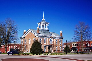
Manchester is a city in Coffee County, Tennessee, United States. The population was 10,102 at the 2010 census. It is the county seat of Coffee County. The city is located halfway between Nashville and Chattanooga on Interstate 24.
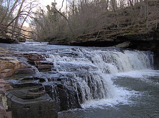
The Little Duck River is a 6.5-mile-long (10.5 km) tributary of the Duck River of Tennessee in the United States. Via the Duck, Tennessee, and Ohio rivers, it is part of the Mississippi River watershed. It rises in a poorly drained, swampy area southeast of Manchester, Tennessee and winds through the town.

The Duck River, 284 miles (457 km) long, is the longest river located entirely within the U.S. state of Tennessee. Free flowing for most of its length, the Duck River is home to over 50 species of freshwater mussels and 151 species of fish, making it the most biologically diverse river in North America.
Broglen River is a 12.3-mile-long (19.8 km) river in Cullman County, Alabama. Broglen River originates at 34.14482°N 86.76860°W near Hanceville, and discharges into the Mulberry Fork River at 34.06204°N 86.69610°W near Chamblees Mill.
The Whitefish River is an 11.9-mile-long (19.2 km) river on the Upper Peninsula of the U.S. state of Michigan. The mouth of the river is in Delta County at 45°54′34″N86°58′01″W on the Little Bay De Noc of Lake Michigan. The main branch of the river is formed by the confluence of the east and west branches at 46°03′25″N86°52′17″W.

Lost River Township is one of six townships in Martin County, Indiana, United States. As of the 2010 census, its population was 572 and it contained 265 housing units.

Tippecanoe Township is one of twelve townships in Pulaski County, Indiana, United States. As of the 2010 census, its population was 1,104 and it contained 580 housing units.

Van Buren Township is one of eleven townships in Monroe County, Indiana, United States. As of the 2010 census, its population was 11,981 and it contained 5,347 housing units.

Guthrie Township is one of nine townships in Lawrence County, Indiana, United States. As of the 2010 census, its population was 1,383 and it contained 654 housing units.

Paoli Township is one of ten townships in Orange County, Indiana, United States. As of the 2010 census, its population was 6,031 and it contained 2,679 housing units.

Pierce Township is one of thirteen townships in Washington County, Indiana, United States. As of the 2010 census, its population was 2,666 and it contained 1,146 housing units.

The Betsie River is a 54.0-mile-long (86.9 km) stream in the northwest part of the U.S. state of Michigan. The name is derived from the French la rivière aux Bec-scies, meaning river of sawbill ducks (bec-scie). Other alternate names include Aug-sig-o-sebe, Aux Buscies, Betsey's River, Black Robe, Gay-she-say-ing, Riviere du Pere Marquette, Sawbill Ducks, and Shelldrake Ducks. The river is mostly within Benzie County, although the river rises in southwest Grand Traverse County and flows briefly through northern Manistee County, Michigan.
Mountain is a rural municipality in the province of Manitoba in Western Canada. It consists of two disjoint parts, Mountain (North) at 52°34′48″N101°00′54″W, and Mountain (South) at 51°58′21″N100°23′31″W, separated by the Rural Municipality of Minitonas. The two parts are separated by approximately 10 km at the northeast corner of Minitonas, along its border with unorganized territory of Division No. 19.
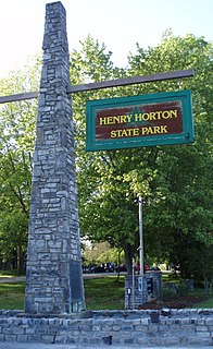
Henry Horton State Park is a state park located near Chapel Hill, Tennessee, United States. The park was constructed in the 1960s on the estate of the former governor of Tennessee, Henry Horton.

Noah is an unincorporated community in Coffee County, Tennessee. In 1887 it was described as being 8.5 miles (13.7 km) north of the county seat of Manchester and having a population between 50 and 100. Noah is believed to be the first settlement in Coffee County, having been settled on the Noah Fork of the Duck River about 1800 by the Patton Brothers, John, Daniel, and Neely.
The Narramissic River is a 1.7-mile-long (2.7 km) river in Hancock County, Maine. It is the furthest downstream freshwater section in the Narramissic watershed.

Indian River is a 59.1-mile-long (95.1 km) tributary of the Manistique River on the Upper Peninsula of Michigan in the United States. It rises out of Hovey Lake at 46°17′36″N86°42′20″W on Hiawatha National Forest land in Alger County and flows south and east through a lake district and on through Schoolcraft County. The river flows into the 8,659 acre (35 km²) Indian Lake at 46°17′36″N86°42′20″W and flows out at 45°59′30″N86°17′15″W. It then flows east and south about 2.5 miles where it merges with the Manistique River, which then flows through Manistique and into Lake Michigan at 45°56′56″N86°14′45″W.

The Duck River is a short, partly tidal stream in Old Lyme, Connecticut. It joins the Connecticut River in the estuary at Watch Rock Park, just above the point where the Connecticut flows into Long Island Sound.
Fountain Creek is a creek in Maury County, Tennessee. It is a tributary of the Duck River.


