Duist

Last updated

Duist is a former municipality in the Dutch province of Utrecht, located between Amersfoort and Bunschoten. The municipality existed between 1818 and 1857, when it was merged with the municipality of Hoogland. [1] When Hoogland was annexed by Amersfoort in 1974, the Duist area was split off, and merged with the municipality of Bunschoten.

Netherlands Constituent country of the Kingdom of the Netherlands in Europe

The Netherlands is a country located mainly in Northwestern Europe. The European portion of the Netherlands consists of twelve separate provinces that border Germany to the east, Belgium to the south, and the North Sea to the northwest, with maritime borders in the North Sea with Belgium, Germany and the United Kingdom. Together with three island territories in the Caribbean Sea—Bonaire, Sint Eustatius and Saba— it forms a constituent country of the Kingdom of the Netherlands. The official language is Dutch, but a secondary official language in the province of Friesland is West Frisian.

Utrecht (province) Province of the Netherlands

Utrecht is a province of the Netherlands. It is located in the centre of the country, bordering the Eemmeer in the north-east, the province of Gelderland in the east and south-east, the province of South Holland in the west and south-west and the province of North Holland in the north-west and north. With an area of approximately 1,400 square kilometres (540 sq mi), it is the smallest of the twelve Dutch provinces. Apart from its eponymous capital, major cities in the province are Amersfoort, Houten, Nieuwegein, Veenendaal, IJsselstein and Zeist.

Amersfoort City and municipality in Utrecht, Netherlands

Amersfoort[ˈaːmərsfoːrt](listen) is a city and municipality in the province of Utrecht, Netherlands. In August 2017, the municipality had a population of 155,089, making it the second-largest of the province and fifteenth-largest of the country. Amersfoort is also one of the largest Dutch railway junctions with its three stations—Amersfoort, Schothorst and Vathorst—due to its location on two of the Netherlands' main east to west and north to south railway lines. The city was used during the 1928 Summer Olympics as a venue for the modern pentathlon events. Amersfoort marked its 750th anniversary as a city in 2009.

The municipality of Duist contained the village of Zevenhuizen and the polder De Haar.

Polder low-lying tract of land enclosed by embankments (barriers) known as dikes

A polder is a low-lying tract of land enclosed by dikes that form an artificial hydrological entity, meaning it has no connection with outside water other than through manually operated devices. There are three types of polder:

  1. Land reclaimed from a body of water, such as a lake or the sea bed
  2. Flood plains separated from the sea or river by a dike
  3. Marshes separated from the surrounding water by a dike and subsequently drained; these are also known as koogs especially in Germany

Related Research Articles

Gorssel Village in Gelderland, Netherlands

Gorssel is a village in the Dutch province of Gelderland. It is located in the municipality of Lochem, about 6 km southeast of Deventer.

Amerongen Place in Utrecht, Netherlands

Amerongen is a village in the central Netherlands on the border of the Utrecht Hill Ridge. It lies about 7 km south west of Veenendaal.

Bunschoten Municipality in Utrecht, Netherlands

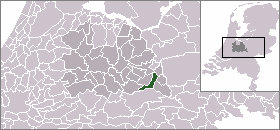
Bunschoten is a municipality and a town in the Netherlands, in the province of Utrecht. It lies about 7 km north of Amersfoort. Its territory comprises the original municipality of Bunschoten and the former municipality of Duyst, De Haar and Zevenhuizen, which was a part of Hoogland from 1854 until 1971.

Driebergen Place in Utrecht, Netherlands

Driebergen is a former village and municipality in the Dutch province of Utrecht. It is first mentioned as Thriberghen in 1159. The former municipality of Driebergen existed until 1931, when it merged with Rijsenburg, to create the new municipality of Driebergen-Rijsenburg. In later years, due to growth of the villages of Driebergen and Rijsenburg, the villages themselves also merged, to become the single town of Driebergen-Rijsenburg. Since 2006, Driebergen-Rijsenburg is part of the new municipality Utrechtse Heuvelrug.

Hooglanderveen Place in Utrecht, Netherlands

Hooglanderveen is a village in the Dutch province of Utrecht. It is a part of the municipality of Amersfoort, and lies about 4 km northeast of Amersfoort. It is notable for the presence of a large catholic church.

Den Dolder Place in Utrecht, Netherlands

Den Dolder is a town in the Dutch province of Utrecht. It is a part of the municipality of Zeist, and lies about 4 km northeast of Bilthoven. Den Dolder has a railway station on the route between Amersfoort and Utrecht and is best known for its mental institutions such as Dennendal and the Willem Arntz Hoeve. Den Dolder also houses the big Dutch sauce manufacturer Remia referring to Den Dolder as Holland's Heart of Sauces as is depicted on the factory's side and is visible from the train passing by.

Lunteren Village in Gelderland, Netherlands


Lunteren is a town in Gelderland, the Netherlands. It has a railway station on the line between Amersfoort and Ede.

Pijnacker is a town in the Dutch province of South Holland. It is located about 4 km east of the city of Delft, in the municipality of Pijnacker-Nootdorp.

Hoogmade Place in Zuid-Holland, Netherlands

Hoogmade is a village in the Dutch province of South Holland. It is located about 7 km east of Leiden, in the municipality of Kaag en Braassem.

Spakenburg Place in Utrecht, Netherlands

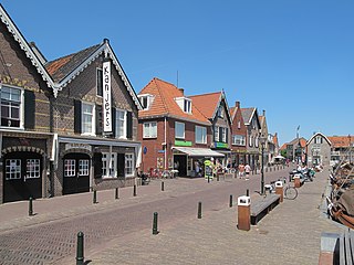
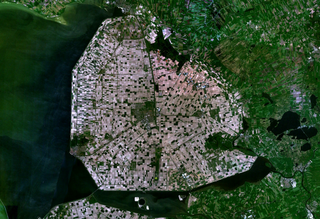
Spakenburg is a Dutch village north of Bunschoten. Spakenburg is formally called Bunschoten-Spakenburg since its fusion with Bunschoten. The village lies south of the IJsselmeer in the municipality Bunschoten, Utrecht. It is one of the few places left in the Netherlands where some women still wear local traditional clothes.

Langbroek Place in Utrecht, Netherlands

Langbroek is a town in the Dutch province of Utrecht. It is a part of the municipality of Wijk bij Duurstede, and lies about 11 km southeast of Zeist.

Zevenhuizen, Bunschoten Hamlet in Utrecht, Netherlands

Zevenhuizen is a hamlet in the Dutch province of Utrecht. It is a part of the municipality of Bunschoten, and lies about 6 km north of the centre of Amersfoort. The village consists of a single road, the Zevenhuizerstraat.

Ransdorp Neighbourhood of Amsterdam in North Holland, Netherlands

Ransdorp is a village in the province of North Holland, Netherlands, part of the municipality of Amsterdam. It lies about 7 km northeast of the city centre, in the Landelijk Noord district. Ransdorp is a part of the borough Amsterdam-Noord and has about 245 inhabitants.

Catharijne is a former municipality on the west side of the Dutch city of Utrecht. It was a separate municipality between 1818 and 1823, when it merged with the city of Utrecht.

Loenen-Kronenburg was a Dutch municipality from 1817 to '19. Its former territory is now part of Loenen in the province of Utrecht.

Loenen, Apeldoorn Village in Gelderland, Netherlands

Loenen is a village in the Dutch province of Gelderland. It is located in the municipality of Apeldoorn, about 10 km southeast of that city.

Vrijhoef en Kalverbroek human settlement in the Netherlands

Vrijhoef en Kalverbroek is a former heerlijkheid (manor) and municipality in the Dutch province of South Holland. It was located about 3 km east of the city of Gouda, in the current municipality of Reeuwijk. The area of the former municipality is now almost completely covered by the lakes of the Reeuwijksche Plassen.

Amersfoort railway station railway station in the Dutch city of Amersfoort

Amersfoort railway station is the main railway station in Amersfoort, in the province of Utrecht, Netherlands. The station was an important link between the western part of the Netherlands and the north and east of the country until December 2012 when the Hanzelijn opened.

References

  1. Ad van der Meer and Onno Boonstra, "Repertorium van Nederlandse gemeenten", KNAW, 2006. "Archived copy". Archived from the original on 2007-02-20. Retrieved 2009-12-03.

Coordinates: 52°13′01″N5°23′01″E / 52.2170°N 5.3836°E / 52.2170; 5.3836

Geographic coordinate system Coordinate system

A geographic coordinate system is a coordinate system that enables every location on Earth to be specified by a set of numbers, letters or symbols. The coordinates are often chosen such that one of the numbers represents a vertical position and two or three of the numbers represent a horizontal position; alternatively, a geographic position may be expressed in a combined three-dimensional Cartesian vector. A common choice of coordinates is latitude, longitude and elevation. To specify a location on a plane requires a map projection.