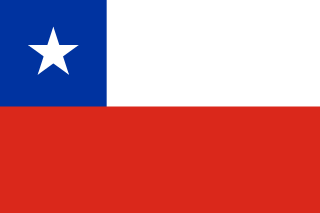
Chile, officially the Republic of Chile, is a country in western South America. It is the southernmost country in the world and the closest to Antarctica, stretching along a narrow strip of land between the Andes Mountains and the Pacific Ocean. With an area of 756,102 square kilometers (291,933 sq mi) and a population of 17.5 million as of 2017, Chile shares borders with Peru to the north, Bolivia to the northeast, Argentina to the east, and the Drake Passage to the south. The country also controls several Pacific islands, including Juan Fernández, Isla Salas y Gómez, Desventuradas, and Easter Island, and claims about 1,250,000 square kilometers (480,000 sq mi) of Antarctica as the Chilean Antarctic Territory. The capital and largest city of Chile is Santiago, and the national language is Spanish.

South America is a continent entirely in the Western Hemisphere and mostly in the Southern Hemisphere, with a considerably smaller portion in the Northern Hemisphere. It can also be described as the southern subregion of the Americas.

The Americas, sometimes collectively called America, are a landmass comprising the totality of North and South America. The Americas make up most of the land in Earth's Western Hemisphere and comprise the New World.

The Netherlands began its colonization of the Americas with the establishment of trading posts and plantations, which preceded the much wider known colonization activities of the Dutch in Asia. While the first Dutch fort in Asia was built in 1600 in present-day Indonesia, the first forts and settlements along the Essequibo River in Guyana date from the 1590s. Actual colonization, with the Dutch settling in the new lands, was not as common as by other European nations.

The Southern Hemisphere is the half (hemisphere) of Earth that is south of the Equator. It contains all or parts of five continents and four oceans, as well as New Zealand and most of the Pacific Islands in Oceania. Its surface is 80.9% water, compared with 60.7% water in the Northern Hemisphere, and it contains 32.7% of Earth's land.

The Desventuradas Islands is a group of four small oceanic islands located 850 kilometres (530 mi) off the coast of Chile, northwest of Santiago in the Pacific Ocean. They are considered part of Insular Chile.
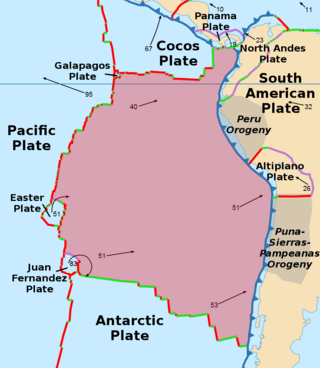
The Nazca Plate or Nasca Plate, named after the Nazca region of southern Peru, is an oceanic tectonic plate in the eastern Pacific Ocean basin off the west coast of South America. The ongoing subduction, along the Peru–Chile Trench, of the Nazca Plate under the South American Plate is largely responsible for the Andean orogeny. The Nazca Plate is bounded on the west by the Pacific Plate and to the south by the Antarctic Plate through the East Pacific Rise and the Chile Rise respectively. The movement of the Nazca Plate over several hotspots has created some volcanic islands as well as east–west running seamount chains that subduct under South America. Nazca is a relatively young plate both in terms of the age of its rocks and its existence as an independent plate having been formed from the break-up of the Farallon Plate about 23 million years ago. The oldest rocks of the plate are about 50 million years old.

The South Shetland Islands are a group of Antarctic islands with a total area of 3,687 km2 (1,424 sq mi). They lie about 120 kilometres north of the Antarctic Peninsula, and between 430 and 900 km southwest of the nearest point of the South Orkney Islands. By the Antarctic Treaty of 1959, the islands' sovereignty is neither recognized nor disputed by the signatories and they are free for use by any signatory for non-military purposes.
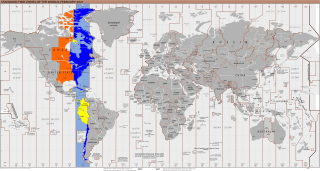
UTC−05:00 is an identifier for a time offset from UTC of −05:00. In North America, it is observed in the Eastern Time Zone during standard time, and in the Central Time Zone during the other eight months. The western Caribbean uses it year round.

The Asia–Pacific (APAC) is the region of the world adjoining the western Pacific Ocean. The region's precise boundaries vary depending on context, but countries and territories in Australasia, East Asia, and Southeast Asia are often included. In a wider context, Central Asia, North Asia, the Pacific Islands, South Asia, West Asia, and even Pacific-adjoining countries in the Americas can be included. For example, the Asia-Pacific Economic Cooperation (APEC) includes five countries in the New World. The term has become popular since the late 1980s in commerce, finance, and politics. Despite the heterogeneity of the regions' economies, most individual nations within the zone are emerging markets experiencing rapid growth. Sometimes, the notion of "Asia–Pacific excluding Japan" (APEJ) is considered useful.

Mataveri International Airport or Isla de Pascua Airport is at Hanga Roa on Rapa Nui /. The most remote airport in the world, it is 2,336 miles (3,759 km) from Santiago, Chile (SCL) which has scheduled flights to it on the Chilean carrier LATAM Chile. The runway starts just inland from the island's southeast coast at Mataveri, and nearly reaches the west coast, almost separating the mountain of Rano Kau from the rest of the island. The airport is the main point of entry for visitors to Easter Island. It has a transit lounge that was formerly used by passengers continuing to or returning from Papeete, Tahiti, which was serviced by LATAM until June 2020.

UTC−04:00 is an identifier for a time offset from UTC of −04:00.

The Chincha Islands War, also known as Spanish–South American War, was a series of coastal and naval battles between Spain and its former colonies of Peru, Chile, Ecuador, and Bolivia from 1865 to 1879. The conflict began with Spain's seizure of the guano-rich Chincha Islands in one of a series of attempts by Spain, under Isabella II, to reassert its influence over its former South American colonies. The war saw the use of ironclads, including the Spanish ship Numancia, the first ironclad to circumnavigate the world.
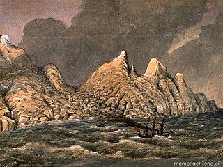
Desolación Island is an island at the western end of the Strait of Magellan in the Magallanes y la Antártica Chilena Region, Chile.
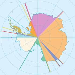
Seven sovereign states – Argentina, Australia, Chile, France, New Zealand, Norway, and the United Kingdom – have made eight territorial claims in Antarctica. These countries have tended to place their Antarctic scientific observation and study facilities within their respective claimed territories; however, a number of such facilities are located outside of the area claimed by their respective countries of operation, and countries without claims such as China, India, Italy, Japan, Pakistan, Russia, South Africa (SANAE), Poland, and the United States have constructed research facilities within the areas claimed by other countries. There are overlaps among the territories claimed by Argentina, Chile, and the United Kingdom.

Since the mid-1990s, tourism in Chile has become one of the main sources of income for the country, especially in its most extreme areas. In 2005, this sector grew by 13.6%, generating more than US$500 million, equivalent to 1.33% of the national GDP.
The South American Board of New Football Federations, also known by its acronym COSANFF is the administrative and controlling body for non-FIFA football federations in South America. It was also initially affiliated with the now defunct N.F.-Board.

Chilean expansionism refers to the foreign policy of Chile to expand its territorial control over key strategic locations and economic resources as a means to ensure its national security and assert its power in South America. Chile's significant territorial acquisitions, which occurred mostly throughout the 19th century, paved the way for its emergence as a thalassocracy and one of the three most powerful and wealthiest states in South America during the 20th century. It also formed Chile's geopolitical and national identity as a tricontinental state and one of the countries with the longest coastlines in the world.


