Related Research Articles


Hydroelectricity, or hydroelectric power, is electricity generated from hydropower. Hydropower supplies one sixth of the world's electricity, almost 4500 TWh in 2020, which is more than all other renewable sources combined and also more than nuclear power. Hydropower can provide large amounts of low-carbon electricity on demand, making it a key element for creating secure and clean electricity supply systems. A hydroelectric power station that has a dam and reservoir is a flexible source, since the amount of electricity produced can be increased or decreased in seconds or minutes in response to varying electricity demand. Once a hydroelectric complex is constructed, it produces no direct waste, and almost always emits considerably less greenhouse gas than fossil fuel-powered energy plants. However, when constructed in lowland rainforest areas, where part of the forest is inundated, substantial amounts of greenhouse gases may be emitted.

Nagarjuna Sagar Dam is a masonry dam across the Krishna River at Nagarjuna Sagar which straddles the border between Palnadu district in Andhra Pradesh and Nalgonda district in Telangana. The dam provides irrigation water to the districts of Palnadu, Guntur, Nalgonda, Prakasam, Khammam, Krishna, and parts of West Godavari. It is also a source of electricity generation for the national grid.

Blagdon Lake lies in a valley at the northern edge of the Mendip Hills, close to the village of Blagdon and approximately 10 miles (16 km) south of Bristol, England. The lake was created by Bristol Water, when it dammed the River Yeo, starting construction in 1898, to designs by Charles Hawksley, and completing this in 1905. The Wrington Vale Light Railway was constructed primarily to bring building materials for the lake.

A hydraulic power network is a system of interconnected pipes carrying pressurized liquid used to transmit mechanical power from a power source, like a pump, to hydraulic equipment like lifts or motors. The system is analogous to an electrical grid transmitting power from a generating station to end-users. Only a few hydraulic power transmission networks are still in use; modern hydraulic equipment has a pump built into the machine. In the late 19th century, a hydraulic network might have been used in a factory, with a central steam engine or water turbine driving a pump and a system of high-pressure pipes transmitting power to various machines.

Lake Qaraoun is an artificial lake or reservoir located in the southern region of the Beqaa Valley, Lebanon. It was created near Qaraoun village in 1959 by building a 61 m-high (200 ft) concrete-faced rockfill dam in the middle reaches of the Litani River. The reservoir has been used for hydropower generation, domestic water supply, and for irrigation of 27,500 ha.

The Staines Reservoirs are two large pumped storage reservoirs sitting to the east of the King George VI Reservoir near Heathrow airport in Surrey within the Colne Valley regional park. The village of Stanwell is mainly to the north east, and the town of Staines is to the south.
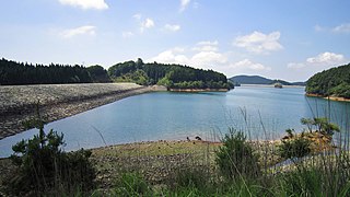
Hickory Log Creek Dam is a gravity dam on the Hickory Log Creek which runs from northeast and north-central Cherokee County, Georgia, United States, south-southwest to the northeastern part of Canton, the county seat. It is a tributary of the Etowah River, which it meets shortly after crossing under Riverstone Parkway.
Kidston Dam also known as Copperfield Dam is a dam in Lyndhurst, Shire of Etheridge, Queensland, Australia. It is approximately 200 kilometres (120 mi) north of Hughenden and was built for the Kidston Gold Mine. The mine closed July 2001. The lake created by the dam has a capacity of 20,600 megalitres.

The Oroville–Thermalito Complex is a group of reservoirs, structures, and facilities located in and around the city of Oroville in Butte County, California. The complex serves not only as a regional water conveyance and storage system, but is the headwaters for, and therefore perhaps is the most vital part of, the California Department of Water Resources' State Water Project, as one of the largest publicly built and operated water and power development and conveyance systems.

Walka Water Works is a heritage-listed 19th-century pumping station at 55 Scobies Lane, Oakhampton Heights, City of Maitland, New South Wales, Australia. Originally built in 1887 to supply water to Newcastle and the lower Hunter Valley, it has since been restored and preserved and is part of Maitland City Council's Walka Recreation and Wildlife Reserve. It was added to the New South Wales State Heritage Register on 2 April 1999.

Rivelin Dams are a pair of water storage reservoirs situated in the upper part of the Rivelin Valley, 5 miles (8 km) west of Sheffield in South Yorkshire, England. The dams are owned by Yorkshire Water and provide water to 319,000 people as well as compensation water for the River Rivelin. They are named Upper and Lower and fall just within the eastern boundary of the Peak District.
The Lam Takhong Dam is an embankment dam on the Lam Takhong River between Pak Chong District and Sikhio District in Nakhon Ratchasima Province, Thailand. The dam was originally constructed in 1974 for the purposes of irrigation and water supply but after 2002, its water storage also serves as the lower reservoir for the Lam Takhong pumped storage power plant, Thailand's first power plant of that type.

The Tungabhadra Dam, also known as Pampa Sagar, is a water reservoir constructed across the Tungabhadra River in the city of Hosapete in Vijayanagara district, Karnataka, India. It is a multipurpose dam serving irrigation, electricity generation, flood control, etc. for the state. It is one of the only two non-cement dams in India, the other being the Mullaperiyar Dam in Kerala. The dam is built of surki mortar, a combination of mud and limestone, commonly used at the time of its construction.
Grahamstown Dam is a major off-stream earthfill Embankment dam with a controlled labyrinth spillway and baffle chute that stores water from the Williams River. The dam is located north of Newcastle, New South Wales, Australia. The dam's main purpose is water supply; it provides about 40 per cent of the potable water for the Hunter Region; and is its largest drinking water supply dam.

The Manly Dam is a heritage-listed dam near King Street, Manly Vale with a reservoir extending into Allambie Heights, both in the Northern Beaches Council local government area of New South Wales, Australia. It is often used as a place to have recreational activities. The reservoir is located within the Manly Dam Reserve. The dam was designed by the NSW Department of Public Works and built in 1892 by the Department. The reservoir and dam is owned by Sydney Water, an agency of the Government of New South Wales. The reservoir and dam was added to the New South Wales State Heritage Register on 18 November 1999.
Rand Water is a South African water utility that supplies potable water to the Gauteng province and other areas of the country and is the largest water utility in Africa. The water is drawn from numerous sources and is purified and supplied to industry, mining and local municipalities and is also involved in sanitation of waste water.

The Foss Barrier consists of a retractable floodgate and pumping station owned and managed by the Environment Agency. It straddles the River Foss in York, just above the confluence with the River Ouse. The barrier’s purpose is to prevent water from the Ouse flowing upstream into the Foss, raising water levels and flooding properties along the River Foss. The pumps next to the flood gate move water around the barrier via a side culvert so that it can continue to drain into the Ouse. This prevents water levels on the Foss rising when the barrier is closed. The Ouse’s normal water level at York is approximately 5 metres AOD. When the river level reaches 7.5 metres AOD, the barrier is lowered into the Foss, shutting it off from the Ouse. The electrically driven barrier takes less than five minutes to lower into position. The barrier operates as a ‘turn and lift’ gate so it opens and closes in a similar way to a garage door. The pump-house attached to the barrier maintain the water level in the Foss at around 6.5 metres AOD. When the flood subsides and the level of the Ouse drops back to 6.5 metres, the levels in both rivers are equalised so the barrier opens, and the pumps shut down.
References
- ↑ "A Look Into Lisburn's Water Resources". Lisburn Miscellany (by Fred Kee, Lisburn Historical Society, 1976). Retrieved 12 July 2008.