Related Research Articles

Van Mijenfjorden is the third-longest fjord in Norway's Svalbard archipelago. It lies in the southern portion of Spitsbergen island, south of Nordenskiöld Land and north of Nathorst Land. The fjord is 83 km (52 mi) long, being separated from Bellsund further out by Akseløya and Mariaholmen. The settlement of Sveagruva lies on the fjord's north bank.
Lægerneset is a headland on the eastern side of Recherche Fjord, Svalbard. It was once known as "Whale Head" or "Edge's Point", which was named after the English merchant and whaler Thomas Edge. An English whaling station was situated on the point in the first half of the 17th century.

Akseløya is a long, narrow island at the mouth of Van Mijenfjorden, separating Van Mijenfjorden from Bellsund. It is separated from the mainland by Akselsundet to the north, and another narrow strait to the south. The islands are named after the schooner Aksel Thordsen, which was chartered by Adolf Erik Nordenskiöld for an expedition to Svalbard in 1864.
Wedel Jarlsberg Land is the land area between Van Keulenfjorden and Hornsund on the southwestern part of Spitsbergen, Svalbard. The area is largely covered with glaciers, and is completely within the Sør-Spitsbergen National Park.
Nathorst Land is the land area between Van Keulenfjorden and Van Mijenfjorden on Spitsbergen, Svalbard.
Torell Land is a land area at the southeast part of Spitsbergen, Svalbard. It is named after Otto Martin Torell. Two glaciers, Hornbreen and Hambergbreen, divide Torell Land from Sørkapp Land.

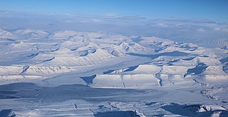
Heer Land is a land area on the east coast of Spitsbergen, Svalbard. It is bordered by Rindersbukta to the southwest, Braganzavågen and Kjellströmdalen to the northwest, Storfjorden to the east and southeast, and Torell Land to the south. It is named after paleobotanist Oswald Heer. Heer Land mainly consist of glaciers and nunataks.
Grøndalen is a valley in Nordenskiöld Land at Spitsbergen, Svalbard. It has a length of about 19 kilometers. The valley stretches westwards from the mountain pass Grøndalspasset, and debouches into Grønfjorden, at the eastern side of the fjord. The river Grøndalselva flows through the valley.

Fridtjovbreen is a glacier in Nordenskiöld Land at Spitsbergen, Svalbard. It has a length of about 14 kilometers, and debouches into the bay Fridtjovhamna at the northern side of Van Mijenfjorden. The name stems from a hunting vessel used during the Torell expedition to Spitsbergen. The lower part of the glacier is included in the Nordenskiöld Land National Park.
Akselsundet is a sound between Van Mijenfjorden and Bellsund at Spitsbergen, Svalbard. It has a width of about 1.2 kilometers, located north of Akseløya, and is the main entrance to Van Mijenfjorden. There are strong tidal currents in the strait, up to five to six knots. The entrance is marked by a light at Birkelandodden, the northern point of Akseløya.

Renardbreen is a glacier in Wedel Jarlsberg Land at Spitsbergen, Svalbard. The glacier has a length of about 8 kilometers (5.0 mi). It is located between the ridges of Activekammen and Bohlinryggen, and debouches into Recherche Fjord.
Martinfjella is a mountain range in Wedel Jarlsberg Land at Spitsbergen, Svalbard. The range has an extension of about ten kilometers, and is located between the glaciers Antoniabreen and Recherchebreen. Among the mountains are Maria Theresiatoppen, Jarnfjellet, Magnethøgda, Durochertoppen, Bienaimétoppane and Gavltoppane.
Konglomeratfjellet is a mountain in Wedel Jarlsberg Land at Spitsbergen, Svalbard. It has a length of about three kilometers, with two summits, the highest peak of 798 m.a.s.l. It is located between Dunderdalen and the Recherchebreen glacier complex, at the northern side of Dunderdalsbreen. Geologically, the mountain consists of conglomerate, which has given its name. The mountain is also the type locality for the Konglomeratfjellet Formation.
Bienaimétoppane are two mountain peaks in Wedel Jarlsberg Land at Spitsbergen, Svalbard. They reach the heights of 767 and 763 m.a.s.l. and are located in the Martinfjella mountain range. The summits are named after French naval officer Amédée Pierre Leonard Bienaimé.
Sefströmkammen is a mountain ridge in Nordenskiöld Land at Spitsbergen, Svalbard. It has a length of about six kilometers, extending along Aurdalen from Søre Aurdalsbre, and comprises the peak of Hamretoppen and other peaks. The ridge is named after Swedish geologist Nils Gabriel Sefström. The glacier-dammed Kamvatnet is located between Sefströmkammen and Fridtjovbreen. The lower ridge of Flathaugen is proximate to Sefströmkammen.
Aldegondabreen is a glacier in Nordenskiöld Land at Spitsbergen, Svalbard, Norway. It is named after Infanta Adelgundes, Duchess of Guimarães. The glacier has a length of about 5.5 kilometers. It flows from Qvigstadfjellet, Christensenfjella and Hermod Petersenfjellet towards Grønfjorden.
Erdmannbreen is a glacier in Nordenskiöld Land at Spitsbergen, Svalbard. It is named after Swedish geologist Axel Joachim Erdmann. The glacier has a length of about six kilometers, and is surrounded by the mountains of Malmberget, Ytterdalsgubben and Kosterfjellet. The river of Ytterdalselva originates from Erdmannbreen and flows through the valley of Ytterdalen to the bay of Van Muydenbukta.
Ytterdalssåta is a mountain in Nordenskiöld Land at Spitsbergen, Svalbard. It has a height of 598 m.a.s.l. and is located between the plain of Lågnesflya and the valley of Ytterdalen. The mountain pass of Ytterskaret separates Ytterdalssåta from the mountain of Skarkampen further north.
Langlifjellet is a mountain in Nathorst Land at Spitsbergen, Svalbard. It has peaks with heights of 1,011, 973 and 885 m.a.s.l. respectively. The mountain is surrounded by the mountains of Sven Nilssonfjellet, Bassøefjellet, and Steindolptoppen, and the glaciers of Løyndbreen, Lundbreen and Langlibreen. The valley of Langlidalen separates Langlifjellet and Sven Nilssonfjellet from the mountain of Rånekampen.
References
- ↑ "Dunderdalsbreen (Svalbard)". Norwegian Polar Institute . Retrieved 1 October 2013.
77°22′11″N14°41′43″E / 77.3697°N 14.6952°E
| | This article about a glacier in Spitsbergen is a stub. You can help Wikipedia by expanding it. |