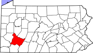
Greene County is a county located in the U.S. state of Pennsylvania. As of the 2010 census, the population was 38,686. Its county seat is Waynesburg. Greene County was created on February 9, 1796, from part of Washington County and named for General Nathanael Greene.

Cockeysville is a census-designated place (CDP) in Baltimore County, Maryland, United States. The population was 20,776 at the 2010 census.
Franklin Township is a township in Greene County, Pennsylvania, United States. The population was 7,280 at the 2010 census, down from 7,694 at the 2000 census.

Morgan Township is a township in Greene County, Pennsylvania, United States. The population was 2,587 at the 2010 census.
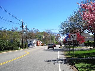
Waynesburg is a borough in and the county seat of Greene County, Pennsylvania, United States, located about 50 miles (80 km) south of Pittsburgh. Its population was 4,176 at the 2010 census.

Washington, referred to locally as Little Washington to distinguish it from Washington, D.C., is a city in and the county seat of Washington County, Pennsylvania, United States, within the Greater Pittsburgh Region in the southwestern part of the state. The population was 13,663 at the 2010 census.

Titusville is an unincorporated community located within Hopewell Township in Mercer County, New Jersey, United States. The area includes a post office with its own ZIP code (08560), a small village of homes, and a large park dedicated to George Washington's crossing of the Delaware River in 1776. Titusville was added to the National Register of Historic Places in 1983.

The Washington and Old Dominion Railroad, the successor to the bankrupt Washington and Old Dominion Railway, was an intrastate short-line railroad located in Northern Virginia. Its oldest line extended from Alexandria on the Potomac River northwest to Bluemont at the foot of the Blue Ridge Mountains near Snickers Gap, not far from the boundary line between Virginia and West Virginia. The railroad's route largely paralleled the routes of the Potomac River and the present Virginia State Route 7.
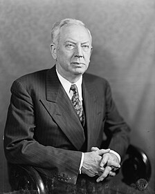
Edward "Ed" Martin was an American lawyer and Republican party politician from Waynesburg, Pennsylvania. He served as the 32nd Governor of Pennsylvania from 1943 until 1947 and as a United States Senator from Pennsylvania from 1947 until 1959.
Deans is an unincorporated community located within South Brunswick Township in Middlesex County, New Jersey, United States.
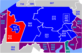
Area code 724 is a Commonwealth of Pennsylvania telephone area code in western and southwestern Pennsylvania, including most of the suburbs of Pittsburgh. It was split from area code 412 on February 1, 1998.
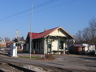
Mars station is a historic train station in Mars, Pennsylvania. It was constructed in 1897 by the Pittsburgh and Western Railroad. For nearly fifty years, the station served the community by helping to transport freight and passengers in the area. The station is located halfway between the cities of Pittsburgh, and Butler.

Waynesburg University is a private university founded in ca. 1850 and located in Waynesburg, Pennsylvania. The university offers undergraduate and graduate programs in more than 70 academic concentrations, and enrolls over 2,500 students, including approximately 1,800 undergraduates.

Condit Crossing is an unincorporated community on Banetown Road in Washington County, Pennsylvania, United States. Condit Crossing is located 28 miles southwest of Pittsburgh in the Eastern Time Zone and has an elevation of 997 feet. Condit Crossing is not a census designated or incorporated place having an official federally recognized name. Condit Crossing appears on the Amity U.S. Geological Survey Map and observes daylight saving time.
Eidenau is an unincorporated community in Jackson Township, Butler County, Pennsylvania, United States.
Blainsburg is an unincorporated outlier community of West Brownsville, PA; by tradition a hamlet sized neighborhood with more actual housing acreage than West Brownsville proper in Washington County, Pennsylvania, United States. Named after a U.S. Senator, James G. Blaine. Blainsburg is part of the California Area School District. West Brownsville residence students attend Brownsville Area School District in Fayette County, Pennsylvania.The bedroom community is situated on the bluff above and slightly North-northwest of West Brownsville on the river bottom below. Blainsburg is located alongside but above the climb PA Route 88 makes from the W. Brownsville river flats which bends right entering a shelf where it connects with the northwest streets of Blainsburg before taking a second ascent towards California. The parent and child communities are on the inside curve of a great meander in the Monongahela River in Southwestern Pennsylvania creating a degraded cut bank turned ramp and terrace on the opposite shore where Brownsville is situated.Blainsburg is often misspelled with an "E" in it,to match the spelling of its namesake, James G. Blaine. Blainsburg as of official records was founded & is still spelled without the "E".
The Five Star Trail runs nearly 8 miles through Westmoreland County, in the U.S. state of Pennsylvania. The trail is alongside an active railroad track, Southwestern Pennsylvania Railroad, that stretches between Lynch Field, a Greensburg city park and Youngwood. The trail then spurs off eastward to connect with the campus of Westmoreland County Community College and continues on to Armbrust.

Keown Station is a small community within Ross Township, Allegheny County, Pennsylvania. Keown Station is located near the corner of Babcock Boulevard and Three Degree Road. The area served as a stop along the Harmony Short Line Railroad which previously ran from the City of Pittsburgh to points north.
Lawrence Station is an unincorporated community located within Lawrence Township in Mercer County, New Jersey, United States. The settlement is named for a former railroad station on the Pennsylvania Railroad's New York Division line, now a part of the Northeast Corridor. Today, some wooded areas and buildings from the time of the station remain but more townhouse developments, cultural centers, and industrial facilities are located along the main road through the area, Lawrence Station Road.