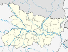
Bhabhua is main city of Kaimur district in the state of Bihar, India. Bhabua is known for the famous historical temple Mundeshwari Temple and the Kaimur Range of hills. It is located 84 km from Varanasi.

Kaimur district is one of the 38 districts of Bihar, India. The district headquarters are at Bhabua. Before 1991, it was part of Rohtas District. Till 1764 the region was a part of Ghazipur District and was a part of Kamsaar Raj and later it was a part of Chainpur Estate till 1837.

The Kosi or Koshi is a transboundary river which flows through China, Nepal and India. It drains the northern slopes of the Himalayas in Tibet and the southern slopes in Nepal. From a major confluence of tributaries north of the Chatra Gorge onwards, the Kosi River is also known as the Saptakoshi for its seven upper tributaries. These include the Tamur River originating from the Kanchenjunga area in the east and Arun River and the Sun Kosi from Tibet. The Sun Koshi's tributaries from east to west are the Dudh Koshi, Likhu Khola, Tamakoshi River, Bhote Koshi and Indravati. The Saptakoshi crosses into northern Bihar, India where it branches into distributaries before joining the Ganges near Kursela in Katihar district. The Kosi is the third-largest tributary of the Ganges by water discharge after the Ghaghara and the Yamuna.

Damodar Valley Corporation (DVC) is a statutory body which operates in the Damodar River area of West Bengal and Jharkhand states of India to handle the Damodar Valley Project, the first multipurpose river valley project of independent India. Indian Astrophysicist Meghnad Saha, the former chief architect of river planning in India, prepared the original plan for the Damodar Valley Project. It operates both thermal power stations and hydel power stations under the ownership of Ministry of Power, Government of India. DVC is headquartered in the Kolkata city of West Bengal, India.
Mohania is a city and corresponding community development block in Kaimur district of Bihar, India. It serves as headquarters for the Mohania sub-division in Kaimur district. It is 17 km (11 mi) by road north of the city of Bhabua, at the intersection of National Highway 19, NH-219, and NH-319. The bank of the Durgavati River is just to the south of Mohania. The total block population was 218,479, in 32,198 households.
Kudra, formerly known as Jahanabad, is a town and corresponding community development block in Kaimur district in the state of Bihar, India. It is the third largest town in Kaimur district. It is situated about 18 km from District Headquarter Bhabua. As of 2011, the population of Kudra was 30986. The railway station in Kudra is connected to all major railway routes.

Lift irrigation is a method of irrigation in which water is not transported by natural flow, but is lifted with pumps or surge pools etc.

Jayakwadi dam is an earthen dam located on Godavari river at the site of Jayakwadi village in Paithan taluka of Sambhajinagar district in Maharashtra, India. It is a multipurpose project. The water is mainly used to irrigate agricultural land in the drought-prone Marathwada region of the state. It also provides water for drinking and industrial usage to nearby towns and villages and to the municipalities and industrial areas of Sambhajinagar and Jalna districts. The surrounding area of the dam has a garden and a bird sanctuary.

Perunchani Dam is an irrigation dam at Perunchani, in Kalkulam Taluk, Kanyakumari District, in the state of Tamil Nadu, India. It is one of the dams of the Kodayar Irrigation System. As there was water deficiency in the Kodayar Irrigation System, Perunchani Dam was constructed in December 1952 to store flood water of the Paralayar River as an extension. It was built about 1 km (0.62 mi) upstream of the Puthen dam on the Paralayar River. The irrigation system became operational on 2 September 1953. It feeds the left bank irrigation canal system of the Puthen dam, which is the terminal structure of the system.
Chandesh is large village in Nuaon block of Kaimur of Bihar in India. It belongs to the Patna division. It is located 48 km north of district headquarters Bhabua and 172 km from the state capital Patna. It has a population of 34,243 in 395 households. There are numerous general stores, medical, textile, electronic, grocery, and sweet shops. Almost all household things are available in the village bazaar. The village is administered by a panchayat. As of 2022, Jai Prakash Rai is the mukhia of this gram panchayat. The village has recently been awarded an elevated status of "Adarsh Gram" under Pradhan Mantri Adarsh Gram Yojana.
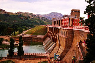
The Krishnagiri Dam is a dam that spans the Thenpennai River by the village of Dhuduganahalli, located in Krishnagiri district, Tamil Nadu, India. The Krishnagiri Dam is also known as Krishnagiri ReservoirProject (KRP) Dam. The KRP Dam is located 7 km (4.3 mi) from Krishnagiri, between Dharmapuri and Krishnagiri which irrigates thousands of acres of land around Krishnagiri. The Dam is operational from 10 November 1957, inaugurated by the Chief Minister of Tamil Nadu K. Kamaraj.

The Durgavati River, which flows through Kaimur district in the Indian state of Bihar, is a tributary of the Karmanasa.

Majalgaon Dam is an earthfill dam on the Sindphana River near Majalgaon, Beed district in the state of Maharashtra, India.

The Bhadra Dam or Lakkavalli Dam, which has created the Bhadra Reservoir, is located on the Bhadra River a tributary of Tungabhadra River. Bhadra Dam is located in the border of Bhadravathi and Tarikere, in the western part of Karnataka in India. The benefits derived from the reservoir storage are irrigation with gross irrigation potential of 162,818 hectares, hydro power generation of 39.2 MW, drinking water supply and industrial use. The dam commissioned in 1965 is a composite earth cum masonry structure of 59.13 metres (194.0 ft) height with length of 1,708 metres (5,604 ft) at the crest level, which submerges a land area of 11,250.88 hectares.
Dildarnagar Kamsar or Kamsaar, is a Pargana or a region of 32 places around Karamnasa river in Ghazipur district, and Kaimur District of Uttar Pradesh, and Bihar, India. Of whom main mouzas being 19. It is a large settlement of pathans mostly Khanzada Pathans and Afghan Pathans.

Irrigation in India includes a network of major and minor canals from Indian rivers, groundwater well based systems, tanks, and other rainwater harvesting projects for agricultural activities. Of these groundwater system is the largest. In 2013–14, only about 36.7% of total agricultural land in India was reliably irrigated, and remaining 2/3 cultivated land in India is dependent on monsoons. 65% of the irrigation in India is from groundwater. Currently about 51% of the agricultural area cultivating food grains is covered by irrigation. The rest of the area is dependent on rainfall which is most of the times unreliable and unpredictable.
Lakhwar-Vyasi Dam project on Yamuna River, includes under-construction Lakhwar Dam and Power Station, Vyasi Dam, Hathiari Power Station and Katapathar Barrage, near the Lakhwar town in Kalsi block of Dehradun district of Uttarakhand in India, for the purpose of irrigation of 40,000 hectare land and total 927 MW hydroelectric power generation. "Lakhwar Dam" is a gravity dam near the Lohari village with 300MW power generation capacity. "Vyasi Dam" will be built 5 km downstream along with 120 MW "Hathiari Power Station" further 0.5 km downstream. "Katapathar Barrage", with the maximum ponding water level at 514.5m elevation, will be built further 2.75 km downstream of the Hathiari Power Station to supply the water to stakeholder states. Project will hold 580 million cubic metres water during monsoon and release into Yamuna during dry months.

The Kanjirapuzha Dam, a masonry earth dam built for providing irrigation to a Cultural Command Area (CCA) of 9,713 hectares, is located in the Palakkad district in the Indian state of Kerala. The reservoir, which has three islands within it, also has an established commercial fisheries development programme operated by the Fisheries Department.
Karmanasa Canal is a Canal located in Kaimur District of Bihar, India. It arises from Kohira River in Chainpur tehsil and ends in Ramgarh Tehsil of Kaimur at Durgawati River. The Karmanasa Canal also have so many Minors arising from it. Its average width is 80 ft.
Meenkara Dam is an embankment or earthen dam built on the banks of the river Gayatripuzha, a tributary of the river Bharathapuzha, at Muthalamada in the Muthalamada Grama Panchayat near Kollengode in the Palakkad district of Kerala with masonry spillway sections. It is part of the Gayatri Irrigation Project. The project was started in 1956 and partially commissioned in 1960. The project was fully completed in 1964. The irrigation scheme has been prepared for agriculture and drinking water in Palakkad district. Farms in Chittoor, Nemmara, Alathur in Palakkad district and Vadakkancherry in Thrissur district will benefit from this irrigation scheme.