Dutch Gap

Last updated
The canal was finished in April 1865 FinishedDutchGapCanalApril1865.jpg
The canal was finished in April 1865
Progress on the digging of Butler's canal in November 1864 DiggingDutchGapCanalNov1864.jpg
Progress on the digging of Butler's canal in November 1864

Dutch Gap is located on Farrar's Island on the James River in Chesterfield County, Virginia; it was started as a canal by Union forces during the American Civil War to cut off a curl of the river known as Farrar's Island, which was controlled by Confederate forts. The canal was completed after the war and is now the main channel of the James River in this area. It is north of the lost 17th-century town of Henricus. [1] Henricus Historical Park is devoted to that town.

Farrars Island

Farrar's Island is a peninsula, jutting out from the south bank of the James River 17.5 miles (28.2 km) south of Richmond, Virginia, known as the Dutch Gap Conservation Area and Henricus Historical Park.

Chesterfield County, Virginia County in the United States

Chesterfield County is a county located just south of Richmond in the Commonwealth of Virginia. The county's borders are primarily defined by the James River to the north and the Appomattox River to the south. Its county seat is Chesterfield Court House.

American Civil War Civil war in the United States from 1861 to 1865

The American Civil War was a war fought in the United States from 1861 to 1865, between the North and the South. The Civil War is the most studied and written about episode in U.S. history. Primarily as a result of the long-standing controversy over the enslavement of black people, war broke out in April 1861 when secessionist forces attacked Fort Sumter in South Carolina shortly after Abraham Lincoln had been inaugurated as the President of the United States. The loyalists of the Union in the North proclaimed support for the Constitution. They faced secessionists of the Confederate States in the South, who advocated for states' rights to uphold slavery.

Contents

History

African-American soldiers at Dutch Gap DutchGapb.jpg
African-American soldiers at Dutch Gap

The name "Dutch Gap" may have a connection to the 1611 Cittie of Henricus. According to an unsubstantiated story, Sir Thomas Dale cut a ditch across the 500 yard wide neck of land behind the new fort, connecting the two parts of the James River. It became known as "Dale's Dutch Gap". This would have protected the rear of the fort from possible attack and shortened the distance upriver. No historical evidence or documentation supports this story, and the connection may come merely from the fact that Dale served the Dutch Republic prior to his employment with the Virginia Company of London, and did create a defensive ditch on the aforementioned neck of land, though the cut was by no means a navigable canal as imagined. This length of the James River had broad, meandering stretches and hairpin turns between Drewry's Bluff, where the river turns east into the coastal plain, and the confluence of the Appomattox River with the James below Bermuda Hundred.

Henricus Town in Virginia, United States of America

The "Citie of Henricus" — also known as Henricopolis, Henrico Town or Henrico — was a settlement in Virginia founded by Sir Thomas Dale in 1611 as an alternative to the swampy and dangerous area around the original English settlement at Jamestown, Virginia. It was named for Prince Henry, the eldest son of King James I.

Thomas Dale English naval commander and deputy-governor of the Virginia Colony

Sir Thomas Dale was an English naval commander and deputy-governor of the Virginia Colony in 1611 and from 1614 to 1616. Governor Dale is best remembered for the energy and the extreme rigour of his administration in Virginia, which established order and in various ways seems to have benefited the colony, although he was criticised for high-handedness. He is also credited with the establishment of Bermuda Hundred, Bermuda Cittie, and the Cittie of Henricus.

Dutch Republic Republican predecessor state of the Netherlands from 1581 to 1795

The Dutch Republic, or the United Provinces, was a confederal republic that existed from the formal creation of a confederacy in 1581 by several Dutch provinces—seceded from Spanish rule—until the Batavian Revolution in 1795. It was a predecessor state of the Netherlands and the first Dutch nation state.

During the American Civil War, Union troops started to construct a larger canal at Dutch Gap late in 1864. Among their workers were paid African-American laborers from the Freedmen's Colony of Roanoke Island. They had been freed by Union forces and were pressed into service away from their base off the mainland of North Carolina. [2]

The Freedmen's Colony of Roanoke Island, also known as the Roanoke Island Freedmen's Colony, or "Freedman's Colony", was founded in 1863 during the Civil War after Union Major General John G. Foster, Commander of the 18th Army Corps, captured the Confederate fortifications on Roanoke Island off North Carolina in 1862. He classified the slaves living there as "contraband", following the precedent of General Benjamin Butler at Fort Monroe in 1861, and did not return them to Confederate slaveholders. In 1863, by the Emancipation Proclamation, all slaves in Union-occupied territories were freed.

By that time, some freedmen were serving as soldiers in the United States Colored Troops. They took part in the military action at Dutch Gap. The Union Army intended to cut off the large curl of the James threatened by Confederate forts, such as Battery Dantzler where Confederate forces had installed two seven inch Brooke rifles, two ten-inch Columbiad guns, and two siege mortars overlooking Trent's Reach to prevent the U.S. navy vessels from approaching the Confederate capital at Richmond.

United States Colored Troops African American soldiers for the Union in the American Civil War

The United States Colored Troops (USCT) were regiments in the United States Army composed primarily of African-American (colored) soldiers, although members of other minority groups also served with the units. They were first recruited during the American Civil War, and by the end of that war in April 1865, the 175 USCT regiments constituted about one-tenth of the manpower of the Union Army. About 20% of USCT soldiers died, a rate about 35% higher than that for white Union troops. Despite heavy casualties, many fought with distinction, with 15 USCT receiving the Medal of Honor and numerous other honors.

Brooke rifle

The Brooke rifle was a type of rifled, muzzle-loading naval and coast defense gun designed by John Mercer Brooke, an officer in the Confederate States Navy. They were produced by plants in Richmond, Virginia and Selma, Alabama between 1861 and 1865 during the American Civil War. They served afloat on Confederate ships and ashore in coast defense batteries manned by the Confederate States Army.

Columbiad

The columbiad was a large-caliber, smoothbore, muzzle-loading cannon able to fire heavy projectiles at both high and low trajectories. This feature enabled the columbiad to fire solid shot or shell to long ranges, making it an excellent seacoast defense weapon for its day. Invented by Colonel George Bomford, United States Army, in 1811, columbiads were used in United States seacoast defense from the War of 1812 until the early years of the 20th century. Very few columbiads were used outside of the U.S. and Confederate Armies; nevertheless, the columbiad is considered by some as the inspiration for the later shell-only cannons developed by Frenchman Henri-Joseph Paixhans some 30 years later.

The Union could not complete expansion of the canal during the war, but it was completed later. It has become the main channel of the James River in that area. An electricity-generating facility of Dominion Virginia Power Company is located nearby on the south shore of the James River.

Dutch Gap Today

The Dutch Gap Conservation Area includes a boat ramp and the archaeological site of Henricus. The Henricus Historical Park is located north of Dutch Gap in Chesterfield County (it was subdivided from Henrico County in 1749. In 1922, Chesterfield annexed the Henricus site from Henrico County. [3] )

Henrico County, Virginia County in the United States

Henrico County, officially the County of Henrico, is a county in the Commonwealth of Virginia in the United States. As of the 2010 census, the population was 306,935. In 2015, the population was estimated to be 320,717, making it the fifth-most populous county in Virginia and the sixth-most populous county-equivalent in Virginia. Henrico County is included in the Greater Richmond Region. There is no incorporated community within Henrico County, therefore, there is no incorporated county seat either. Laurel, an unincorporated CDP, serves this function.

Dutch Gap and Farrar's Island as it appears today Farrar's Island, Dutch Gap & Landing.jpg
Dutch Gap and Farrar's Island as it appears today
Historical Marker, Farrar's Island Farrar's Island Marker.jpg
Historical Marker, Farrar's Island

Related Research Articles

Roanoke Island island in the United States of America

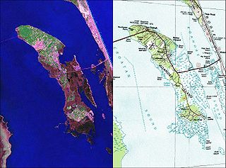
Roanoke Island is an island in Dare County on the Outer Banks of North Carolina, United States. It was named after the historical Roanoke Carolina Algonquian people who inhabited the area in the 16th century at the time of English exploration.

Battle of New Bern battle of the American Civil War

The Battle of New Bern was fought on 14 March 1862, near the city of New Bern, North Carolina, as part of the Burnside Expedition of the American Civil War. The US Army's Coast Division, led by Brigadier General Ambrose Burnside and accompanied by armed vessels from the North Atlantic Blockading Squadron, were opposed by an undermanned and badly trained Confederate force of North Carolina soldiers and militia led by Brigadier General Lawrence O'B. Branch. Although the defenders fought behind breastworks that had been set up before the battle, their line had a weak spot in its center that was exploited by the attacking Federal soldiers. When the center of the line was penetrated, many of the militia broke, forcing a general retreat of the entire Confederate force. General Branch was unable to regain control of his troops until they had retreated to Kinston, more than 30 miles away. New Bern came under Federal control, and remained so for the rest of the war.

Thomas Dowse, also known as Thomas Dawse and Thomas Dawles was an English-American immigrant who represented City of Henricus in the first meeting of the House of Burgesses on July 30, 1619 at Jamestown, Virginia.

Battle of Roanoke Island Battle of the American Civil War

The opening phase of what came to be called the Burnside Expedition, the Battle of Roanoke Island was an amphibious operation of the American Civil War, fought on February 7–8, 1862, in the North Carolina Sounds a short distance south of the Virginia border. The attacking force consisted of a flotilla of gunboats of the Union Navy drawn from the North Atlantic Blockading Squadron, commanded by Flag Officer Louis M. Goldsborough, a separate group of gunboats under Union Army control, and an army division led by Brig. Gen. Ambrose Burnside. The defenders were a group of gunboats from the Confederate States Navy, termed the Mosquito Fleet, under Capt. William F. Lynch, and about 2,000 Confederate soldiers commanded locally by Brig. Gen. Henry A. Wise. The defense was augmented by four forts facing on the water approaches to Roanoke Island, and two outlying batteries. At the time of the battle, Wise was hospitalized, so leadership fell to his second in command, Col. Henry M. Shaw.

This article is about the many neighborhoods and districts in the Greater Richmond, Virginia area. Note that this article is an attempt to be inclusive of the broader definitions of the areas which are often considered part of the Greater Richmond Region, based on their urban or suburban character and nature, rather than by strictly political boundaries.

St. Johns Episcopal Church (Richmond, Virginia)

St. John's Church is an Episcopal church located at 2401 East Broad Street in Richmond, Virginia, United States. Formed from several earlier parishes, St. John's is the oldest church in the city of Richmond, Virginia. It was built in 1741 by William Randolph's son, Colonel Richard Randolph; the Church Hill district was named for it. It was the site of two important conventions in the period leading to the American Revolutionary War, and is famous as the location where Patrick Henry gave his memorable speech at the Second Virginia Convention, closing with the often-quoted demand, "give me liberty, or give me death!" The church is designated as a National Historic Landmark.

Varina is a former unincorporated community and current magisterial district in the easternmost portion of Henrico County, Virginia, United States.

Westham Bridge bridge in United States of America

Westham Bridge crossed the James River between Henrico County and Chesterfield County. The bridge was located between Bosher Dam and Williams Island Dam just west of the 7 miles of rapids and falls which constitute the fall line of the James River at Richmond, Virginia.

Fort Raleigh National Historic Site

Fort Raleigh National Historic Site preserves the location of Roanoke Colony, the first English settlement in the present-day United States. The site was preserved for its national significance in relation to the founding of the first English settlement in North America in 1587. The colony, which was promoted and backed by entrepreneurs led by Englishman Sir Walter Raleigh, failed sometime between 1587 and 1590 when supply ships failed to arrive on time. When next visited, the settlement was abandoned with no survivors found. The fate of the "Lost Colony" remains a mystery.

John G. Foster Union army general

John Gray Foster was a career military officer in the United States Army and a Union general during the American Civil War whose most distinguished services were in North and South Carolina. A postbellum expert in underwater demolition, he wrote the definitive treatise on the subject in 1869. He continued with the Army after the war, using his expertise as assistant to the Chief Engineer in Washington, DC and at a post on Lake Erie.

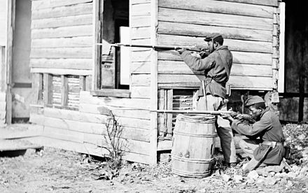
Contraband was a term commonly used in the United States military during the American Civil War to describe a new status for certain escaped slaves or those who affiliated with Union forces. In August 1861, the Union Army determined that the US would no longer return escaped slaves who went to Union lines and classified them as "contraband of war", or captured enemy property. They used many as laborers to support Union efforts and soon began to pay them wages. The former slaves set up camps near Union forces, and the Army helped support and educate both adults and children among the refugees. Thousands of men from these camps enlisted in the United States Colored Troops when recruitment started in 1863. At war's end, more than 100 contraband camps existed in the South, including the Freedmen's Colony of Roanoke Island, where 3500 former slaves worked to develop a self-sufficient community.

Henrico City was one of four incorporations established in the Virginia Colony in 1619 North America by the proprietor, the Virginia Company. The plantations and developments were divided into four "incorporations" or "citties", as they were called. These were Charles City, Elizabeth City, Henrico City, and James City. The latter included the seat of government for the colony at Jamestown. Each of the four citties extended across the James River, the main conduit of transportation of the era.

The Arrohattoc, also occasionally spelled Arrohateck, was a Native American tribe from Henrico County, Virginia in the United States. The tribe was led by their chief Ashuaquid and was part of the Powhatan Confederacy. Their main village was located on the James River, the location of which is now the site of Henrico, Virginia.

References

  1. NOAA Chart 12252 James River: Jordan Point to Richmond, 1/20,000 2004
  2. Click, Patricia C. Time Full of Trial: The Roanoke Island Freedman's Colony, 1862–1867, Chapel Hill, NC: University of North Carolina, 2001
  3. "Henrico County's History". Henrico Historical Society. Retrieved 25 January 2019. an annexation in 1922 by Chesterfield County that claimed the site of Henricus, changing the boundary of Henrico to what it is today.

Coordinates: 37°22′37″N77°21′21″W / 37.3770°N 77.3558°W / 37.3770; -77.3558 David F. Bastian, Union Soldiers Dredge Canal at Dutch Gap to Avoid Rebel Fleet, World Dredging, pp. 22-25, October 1977

Geographic coordinate system Coordinate system

A geographic coordinate system is a coordinate system that enables every location on Earth to be specified by a set of numbers, letters or symbols. The coordinates are often chosen such that one of the numbers represents a vertical position and two or three of the numbers represent a horizontal position; alternatively, a geographic position may be expressed in a combined three-dimensional Cartesian vector. A common choice of coordinates is latitude, longitude and elevation. To specify a location on a plane requires a map projection.