Dwyka River

Last updated

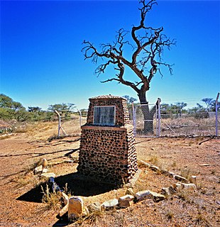
The Dwyka River is located in the Karoo region, in South Africa. It flows from the North-west, joining the Gamka River as a tributary at the Gamka Dam.

Karoo Natural region in South Africa

The Karoo is a semi desert natural region of South Africa. No exact definition of what constitutes the Karoo is available, so its extent is also not precisely defined. The Karoo is partly defined by its topography, geology and climate, and above all, its low rainfall, arid air, cloudless skies, and extremes of heat and cold. The Karoo also hosted a well-preserved ecosystem hundreds of million years ago which is now represented by many fossils.

South Africa Republic in the southernmost part of Africa

South Africa, officially the Republic of South Africa (RSA), is the southernmost country in Africa. It is bounded to the south by 2,798 kilometres (1,739 mi) of coastline of Southern Africa stretching along the South Atlantic and Indian Oceans; to the north by the neighbouring countries of Namibia, Botswana, and Zimbabwe; and to the east and northeast by Mozambique and Eswatini (Swaziland); and it surrounds the enclaved country of Lesotho. South Africa is the largest country in Southern Africa and the 25th-largest country in the world by land area and, with over 57 million people, is the world's 24th-most populous nation. It is the southernmost country on the mainland of the Old World or the Eastern Hemisphere. About 80 percent of South Africans are of Sub-Saharan African ancestry, divided among a variety of ethnic groups speaking different African languages, nine of which have official status. The remaining population consists of Africa's largest communities of European (White), Asian (Indian), and multiracial (Coloured) ancestry.

Gamka River river in South Africa

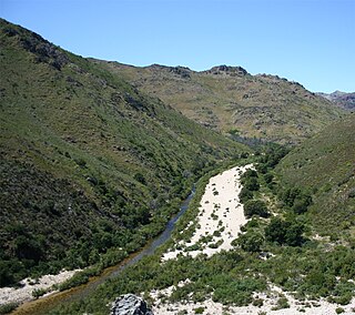
Gamka River is a river located in the Western Cape, South Africa. The name 'Gamka' means 'Lion' and was probably named so by the San people (Bushmen). The river originates north of Beaufort West, generally flowing southwest towards the Gamkapoort Dam.

In the 1870s, the Cape Colony government expanded its railway network inland, towards the diamond fields of Kimberley. A station, also named Dwyka, was built where the line crossed the Dwyka river. [1]

Cape Colony Dutch and British colony in Southern Africa

The Cape of Good Hope, also known as the Cape Colony, was a British colony in present-day South Africa, named after the Cape of Good Hope. The British colony was preceded by an earlier Dutch colony of the same name, the Kaap de Goede Hoop, established in 1652 by the Dutch East India Company. The Cape was under Dutch rule from 1652 to 1795 and again from 1803 to 1806. The Dutch lost the colony to Great Britain following the 1795 Battle of Muizenberg, but had it returned following the 1802 Peace of Amiens. It was re-occupied by the UK following the Battle of Blaauwberg in 1806, and British possession affirmed with the Anglo-Dutch Treaty of 1814.

Cape Government Railways railway operator in the Cape Colony

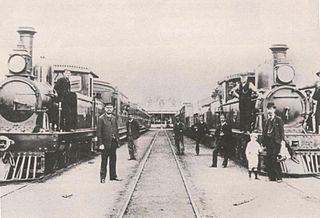
The Cape Government Railways (CGR) was the government-owned railway operator in the Cape Colony from 1874 until the creation of the South African Railways (SAR) in 1910.

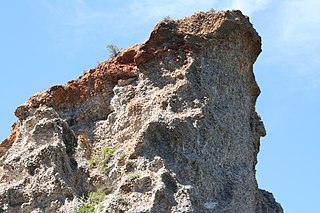
The river's name was subsequently also adopted by geologists to define the Karoo Ice Age some 300 million years ago. Key sites in South Africa show evidence of glaciation, including Nooitgedacht near Kimberley. In South Africa, near the South Pole at that time as a result of plate tectonics, large ice sheets or glaciers covered high-lying areas. Geologists term this upland the Cargonian Highlands, stretching from what is now the Northern Cape through Gauteng to Mpumalanga. [2]

Nooitgedacht Glacial Pavements

The Nooitgedacht Glacial Pavements comprise a geological feature between Kimberley and Barkly West, South Africa, pertaining to the Palaeozoic-age Dwyka Ice Age, or Karoo Ice Age, where the glacially scoured ancient bedrock was used, substantially more recently, during the Later Stone Age period in the late Holocene as panels for rock engravings.

Kimberley, Northern Cape Place in Northern Cape, South Africa

Kimberley is the capital and largest city of the Northern Cape Province of South Africa. It is located approximately 110 km east of the confluence of the Vaal and Orange Rivers. The city has considerable historical significance due to its diamond mining past and the siege during the Second Boer War. British businessmen Cecil Rhodes and Barney Barnato made their fortunes in Kimberley, and Rhodes established the De Beers diamond company in the early days of the mining town.

See also

Dwyka Group Geological group in the Karoo Supergroup from South Africa

The Dwyka Group is one of four geological groups that compose the Karoo Supergroup. It is the lowermost geological group and heralds the commencement of sedimentation of the Karoo Supergroup. Based on stratigraphic position, lithostratigraphic correlation and palynological analyses, these lowermost Karoo strata range between the Late Carboniferous (Pennsylvanian) to Early Permian in age.

Plate tectonics The scientific theory that describes the large-scale motions of Earths lithosphere

Plate tectonics is a scientific theory describing the large-scale motion of seven large plates and the movements of a larger number of smaller plates of the Earth's lithosphere, since tectonic processes began on Earth between 3 and 3.5 billion years ago. The model builds on the concept of continental drift, an idea developed during the first decades of the 20th century. The geoscientific community accepted plate-tectonic theory after seafloor spreading was validated in the late 1950s and early 1960s.

Alexander Logie du Toit FRS was a geologist from South Africa and an early supporter of Alfred Wegener's theory of continental drift.

Related Research Articles

Northern Cape Province of South Africa

The Northern Cape is the largest and most sparsely populated province of South Africa. It was created in 1994 when the Cape Province was split up. Its capital is Kimberley. It includes the Kalahari Gemsbok National Park, part of the Kgalagadi Transfrontier Park, an international park shared with Botswana. It also includes the Augrabies Falls and the diamond mining regions in Kimberley and Alexander Bay. The Namaqualand region in the west is famous for its Namaqualand daisies. The southern towns of De Aar and Colesberg, in the Great Karoo, are major transport nodes between Johannesburg, Cape Town and Port Elizabeth. In the northeast, Kuruman is known as a mission station and also for its artesian spring, the Eye of Kuruman. The Orange River flows through the province, forming the borders with the Free State in the southeast and with Namibia to the northwest. The river is also used to irrigate the many vineyards in the arid region near Upington.

Hopetown Place in Northern Cape, South Africa

Hopetown is a town which lies at the edge of the Great Karoo in South Africa's Northern Cape province. It is situated on an arid slope leading down to the Orange River. The first diamond discovered in South Africa, the Eureka Diamond, was found at Hopetown.

Barkly West Place in Northern Cape, South Africa

Barkly West is a town in the Northern Cape province of South Africa, situated on the north bank of the Vaal River west of Kimberley.

Karoo Supergroup Widespread Mesozoic stratigraphic unit in southern Africa

The Karoo Supergroup is the most widespread stratigraphic unit in Africa south of the Kalahari Desert. The supergroup consists of a sequence of units, mostly of nonmarine origin, deposited between the Late Carboniferous and Early Jurassic, a period of about 120 million years.

Cape Fold Belt A late Paleozoic fold and thrust belt in southwestern South Africa

The Cape Fold Belt is a fold and thrust belt of late Paleozoic age, which affected the sequence of sedimentary rock layers of the Cape Supergroup in the southwestern corner of South Africa. It was originally continuous with the Ventana Mountains near Bahía Blanca in Argentina, the Pensacola Mountains, the Ellsworth Mountains and the Hunter-Bowen orogeny in eastern Australia. The rocks involved are generally sandstones and shales, with the shales persisting in the valley floors while the erosion resistant sandstones form the parallel ranges, the Cape Fold Mountains, which reach a maximum height of 2325 m at Seweweekspoortpiek.

Olifants River (Southern Cape) river in South Africa

Olifants River is a river in the Klein Karoo area of the Western Cape, South Africa.

R62 (South Africa) road in South Africa

The R62 is a provincial route in South Africa that connects Ashton with Humansdorp. The R62 runs through the Little Karoo and the Langkloof, passing through Montagu, Ladismith, Calitzdorp, Oudtshoorn, and Joubertina.

Enon Formation

The Enon Formation is a geological formation found in the Eastern and Western Cape provinces in South Africa. It is the lowermost of the four formations found within the Uitenhage Group of the Algoa Basin, its type locality, where it has been measured at a maximum thickness of 480 metres (1,570 ft). Discontinuous outcrops are also found in the Worcester-Pletmos and Oudshoorn-Gamtoos Basins, including isolated occurrences in the Haasvlakte, Jubilee, and Soutpansvlakte Basins near the small town Bredasdorp.

Gourits River river in the Western Cape, South Africa

Gourits River, sometimes spelled 'Gouritz River', is situated in the Western Cape, South Africa.

De Doorns Place in Western Cape, South Africa

De Doorns is a town in Cape Winelands District Municipality in the Western Cape province of South Africa.

Touws River (town) Place in Western Cape, South Africa

Touws River is a small railway town of 6,800 people in the Western Cape province of South Africa. It is located on the river of the same name, about 160 kilometres (100 mi) north-east of Cape Town. The Touwsrivier CPV Solar Project is located just outside of the town and supplies 50 MW to the national electrical grid.

Leeu-Gamka Place in Western Cape, South Africa

Leeu-Gamka is a small town in the Western Cape province of South Africa, located 355 kilometres (221 mi) north-east of Cape Town in the Karoo.

South African Class 4A 4-8-2 class of 10 South African 4-8-2 locomotives

The South African Railways Class 4A 4-8-2 of 1913 was a steam locomotive.

Buffelspoort

Buffelspoort, is a deep gorge and river valley situated in the Western Cape province of South Africa.

Ganigobis Formation

The Ganigobis Formation is a Late Carboniferous (Gzhelian) to Early Permian (Artinskian) geologic formation of the Dwyka Group in the ǁKaras Region of southeastern Namibia and the Northern Cape of South Africa. The widespread formation was deposited in the Aranos and Karoo Basins of southern Africa.

References

  1. Burman, Jose (1984). Early Railways at the Cape. Cape Town. Human & Rousseau, ISBN   0-7981-1760-5
  2. McCarthy, T. & Rubidge, B. 2005. The story of earth and life: a Southern African perspective on a 4.6-billion-year journey. Kumba Resources. p 195-197.