Related Research Articles
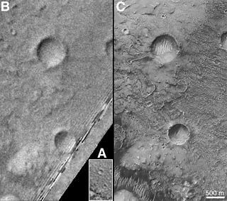
Airy-0 is a crater on Mars whose location defines the position of the prime meridian of that planet. It is about 0.5 kilometres (0.31 mi) across and lies within the larger crater Airy in the region Sinus Meridiani. The IAU Working Group on Cartographic Coordinates and Rotational Elements has now recommended setting the longitude of the Viking 1 lander as the standard. This definition maintains the position of the center of Airy-0 at 0° longitude, within the tolerance of current cartographic uncertainties.

Geomatics is defined in the ISO/TC 211 series of standards as the "discipline concerned with the collection, distribution, storage, analysis, processing, presentation of geographic data or geographic information". Under another definition, it "consists of products, services and tools involved in the collection, integration and management of geographic data". It includes geomatics engineering and is related to geospatial science.

The National Geodetic Survey (NGS), formerly the United States Survey of the Coast (1807–1836), United States Coast Survey (1836–1878), and United States Coast and Geodetic Survey (USC&GS) (1878–1970), is a United States federal agency that defines and manages a national coordinate system, providing the foundation for transportation and communication; mapping and charting; and a large number of applications of science and engineering. Since its foundation in its present form in 1970, it has been part of the National Oceanic and Atmospheric Administration (NOAA), of the United States Department of Commerce.
A geodetic datum or geodetic system is a system for precisely measuring locations on Earth or other planetary body. Datums are crucial to any technology or technique based on spatial location, including geodesy, navigation, surveying, geographic information systems, remote sensing, and cartography. A Horizontal datum is used to measure a location across the Earth's surface, in latitude and longitude or another coordinate system; a vertical datum is used to measure the elevation or depth relative to a standard origin, such as mean sea level (MSL). Since the rise of the global positioning system (GPS), the ellipsoid and datum WGS 84 it uses has supplanted most others in many applications. The WGS 84 is intended for global use, unlike most earlier datums.

Feodosy Nikolaevich Krasovsky was a Russian and later Soviet astronomer and geodesist. He was born in Galich. In 1900 he graduated from the MezhevoyInstitute in Moscow; in 1907 he began working as a lecturer there.
The Survey of India is India's central engineering agency in charge of mapping and surveying. Set up in 1767 to help consolidate the territories of the British East India Company, it is one of the oldest Engineering Departments of the Government of India. Its members are from Survey of India Service cadre of Civil Services of India and Army Officers from the Indian Army Corps of Engineers. It is headed by the Surveyor General of India. At present, Survey of India is headed by Lt Gen Girish Kumar, VSM.com.
The Norwegian Mapping Authority (NMA) is Norway's national mapping agency, dealing with land surveying, geodesy, hydrographic surveying, cadastre and cartography. The current director is Anne Cathrine Frøstrup. Its headquarters are in Hønefoss and it is a public agency under the Ministry of Local Government and Modernisation. NMA was founded in 1773.
The International Association of Oil & Gas Producers (IOGP) is the petroleum industry's global forum in which members identify and share best practices to achieve improvements in health, safety, the environment, security, social responsibility, engineering and operations.
The International Cartographic Association (ICA), is an organization formed of national member organizations, to provide a forum for issues and techniques in cartography and geographic information science (GIScience). ICA was founded on June 9, 1959, in Bern, Switzerland. The first General Assembly was held in Paris in 1961. The mission of the International Cartographic Association is to promote the disciplines and professions of cartography and GIScience in an international context. To achieve these aims, the ICA works with national and international governmental and commercial bodies, and with other international scientific societies.
The Faculty of Geodesy at the University of Zagreb is the only Croatian institution providing high education in Geomatics engineering and the largest faculty in this domain in southeastern Europe.
GeoBase is a federal, provincial and territorial government initiative that is overseen by the Canadian Council on Geomatics (CCOG). It is undertaken to ensure the provision of, and access to, a common, up-to-date and maintained base of quality geospatial data for Canada. Through the GeoBase, users with an interest in geomatics have access to quality geospatial information at no cost and with unrestricted use.
UNAVCO is a non-profit university-governed consortium that facilitates geoscience research and education using Geodesy. UNAVCO is funded by the National Science Foundation (NSF) and The National Aeronautics and Space Administration (NASA) to support geoscience research around the world. UNAVCO operates the GAGE Facility on behalf of the NSF and NASA. As a university-governed consortium, UNAVCO supports the goals of the academic scientific community. UNAVCO has 120 US academic members and supports over 110 organizations globally as associate members.
The Military Geographic Service is a unit of the Bulgarian Armed Forces responsible for meeting the obligations of the Bulgarian Ministry of Defense in the field of cartography and geographic information. This includes the mapping and production of topographic maps of 1:25000 and lesser scale, maintaining the national geodetic network, and providing topographic and geographic data, digital products and information to the Armed Forces, government institutions and private users. According to the 2006 Law of Geodesy and Cartography, the areas subject to such mapping comprise the country’s territory as well as the area of the Bulgarian base in Antarctica.
The Hellenic Geodetic Reference System 1987 or HGRS87 is a geodetic system commonly used in Greece (SRID=2100). The system specifies a local geodetic datum and a projection system. In some documents it is called Greek Geodetic Reference System 1987 or GGRS87.
Kharkiv National University of Radio Electronics (NURE) is a higher education institution of the highest level of accreditation in Ukraine. It is one of the oldest technology universities in Ukraine, with over 7000 students and 30 scientific centers.
The Estonian Land Board is an official body, dealing with cartography and cadastre issues in Estonia. It is subordinated the Ministry of the Environment. The Land Board is a government agency that participates actively in the development and implementation of national land policy and provides the society with up-to-date land-related information. The Land Board's vision is to guarantee the availability and fitness for use of the up-to-date national land information and an efficient management of state assets.
Professional conduct is the field of regulation of members of professional bodies, either acting under statutory or contractual powers.
The Army Map Service (AMS) was the military cartographic agency of the United States Department of Defense from 1941 to 1968, subordinated to the United States Army Corps of Engineers. On September 1, 1968, the AMS was redesignated the U.S. Army Topographic Command (USATC) and continued as an independent organization until January 1, 1972, when it was merged into the new Defense Mapping Agency (DMA) and redesignated as the DMA Topographic Center (DMATC). On October 1, 1996, DMA was folded into the National Imagery and Mapping Agency (NIMA), which was redesignated as the National Geospatial-Intelligence Agency (NGA) on 2003.

Department of Geodesy Gdańsk University of Technology – continues the tradition of the Department of Surveying and Cartography, established at Gdańsk University of Technology in 1945.

In surveying, triangulation is the process of determining the location of a point by measuring only angles to it from known points at either end of a fixed baseline, rather than measuring distances to the point directly as in trilateration. The point can then be fixed as the third point of a triangle with one known side and two known angles.