This article is about transport in Oman.
This article covers the various forms of transport in the United Arab Emirates (UAE), by road, rail, air, water, etc.

Speed limits on road traffic, as used in most countries, set the legal maximum speed at which vehicles may travel on a given stretch of road. Speed limits are generally indicated on a traffic sign reflecting the maximum permitted speed, expressed as kilometres per hour (km/h) or miles per hour (mph) or both. Speed limits are commonly set by the legislative bodies of national or provincial governments and enforced by national or regional police and judicial authorities. Speed limits may also be variable, or in some places nonexistent, such as on most of the Autobahnen in Germany.

Al Ain is a border city on the eastern side of Tawam oasis and the seat of the administrative division, the Al Ain Region, in the Emirate of Abu Dhabi, United Arab Emirates. It is bordered to the east by the Omani town of Al-Buraimi in the Al Buraimi Governorate. It is the largest inland city in the Emirates, the fourth-largest city, and the second-largest in the Emirate of Abu Dhabi. The freeways connecting Al-Ain, Abu Dhabi, and Dubai form a geographic triangle in the country, each city being roughly 130 kilometres (81 mi) from the other two.

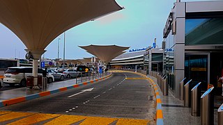
Abu Dhabi International Airport is an international airport in the Emirate of Abu Dhabi, the capital of the United Arab Emirates.

E 11 is a highway in the United Arab Emirates (UAE). The longest road in the Emirates, it stretches from the Al Batha border crossing at the Saudi Arabia–UAE border in al-Silah in the al-Dhafra region of the Emirate of Abu Dhabi and ends at the Oman–UAE border crossing of al-Darah in al-Jeer, Emirate of Ras al-Khaimah, running roughly parallel to UAE's coastline along the Persian Gulf. The road forms the main artery in some emirates' main cities, where it assumes various alternate names —Sheikh Maktoum Bin Rashid Road and Sheikh Khalifa bin Zayed Road in Abu Dhabi, Sheikh Zayed Road in Dubai, Al Ittihad Road in Sharjah Emirate and Ajman Emirate, and Sheikh Muhammad bin Salem Road in Ras al-Khaimah.

E 311 is a major road in the United Arab Emirates. It begins in New Al Falah in Abu Dhabi and extends north-eastward towards the Ras al-Khaimah emirate. E 311 has been called Sheikh Mohammad Bin Zayed Road since January 2013 and is commonly known as SMBZ Road. Prior to that it was called Emirates Road, but that name is now given to E 611, which was previously Dubai Bypass Road.

The Mumbai–Pune Expressway is India's first 6-lane wide concrete, access-controlled tolled expressway. It spans a distance of 94.5 km connecting Mumbai, the capital of Maharashtra state and the financial capital of India, with Pune, the cultural and educational capital of Maharashtra. The expressway, which was fully operationalized in 2002, introduced new levels of speed and safety in automobile transportation to Indian roads. It is one of India's busiest roads.

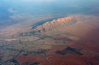
Jabal Hafeet is a mountain in the region of Tawam, on the border of the United Arab Emirates and Oman, which may be considered an outlier of the Hajar Mountains in Eastern Arabia. Due to its proximity to the main Hajar range, the mountain may be considered as being part of the Hajar range. To the north is the UAE city of Al Ain, in the Eastern Region of the Emirate of Abu Dhabi, and the adjacent Omani town of Al-Buraimi.

In the United States, speed limits are set by each state or territory. States have also allowed counties and municipalities to enact typically lower limits. Highway speed limits can range from an urban low of 25 mph (40 km/h) to a rural high of 85 mph (137 km/h). Speed limits are typically posted in increments of five miles per hour (8 km/h). Some states have lower limits for trucks, some also have night and/or minimum speed limits.

Transportation safety in the United States encompasses safety of transportation in the United States, including automobile crashes, airplane crashes, rail crashes, and other mass transit incidents, although the most fatalities are generated by road incidents yearly killing from 32,479 to nearly 38,680 (+19%) in the last decade. The number of deaths per passenger-mile on commercial airlines in the United States between 2000 and 2010 was about 0.2 deaths per 10 billion passenger-miles. For driving, the rate was 150 per 10 billion vehicle-miles: 750 times higher per mile than for flying in a commercial airplane.

E 66 is a road in the United Arab Emirates. The road connects the city of Dubai to the interior city of Al Ain in the Eastern Region of the Emirate of Abu Dhabi. E 66 runs roughly perpendicular to E 11 and E 311. Beginning in the locality of Oud Metha, E 11 progresses southward towards the interior. The road is referred to as "Dubai-Al Ain Road", after its intersection with Emirates Road south of the city of Dubai, and "Tahnoun Bin Mohammad Al Nahyan Road", after Sheikh Tahnoun, the Ruler's Representative in the Eastern Region of Abu Dhabi.

A speed limit is the limit of speed allowed by law for road vehicles, usually the maximum speed allowed. Occasionally, there is a minimum speed limit. Advisory speed limits also exist, which are recommended but not mandatory speeds. Speed limits are commonly set by the legislative bodies of national or local governments.

Etihad Rail is the United Arab Emirates national railway network. It was established in June 2009 under Federal Law No. 2 to manage the development, construction and operation of the United Arab Emirates' national freight and passenger railway network. Etihad Rail aims to link the UAE's principal centres of industry and population, and to link these centres with other railways throughout the Gulf Cooperation Council.

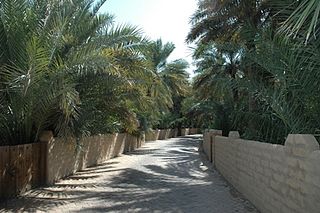
Al-Ain Oasis is the largest oasis in the city of Al Ain, within the Eastern Region of the Emirate of Abu Dhabi, the United Arab Emirates.
Khalifa Port is the Abu Dhabi Ports' flagship deepwater port. It is a gateway to Abu Dhabi and handles all of the emirate’s container traffic. The transfer of container traffic from Zayed Port was completed in December 2012.
The United Arab Emirates employs minimum and maximum speed limits, which vary for different types of vehicles and roads. The roads are monitored by speed cameras to detect traffic violations such as speeding. Heavy vehicles such as trucks, mini buses and buses are installed with speed limiters to prevent overspeeding. The UAE is notable for having the highest posted speed limits in the world, with two major highways, the Abu Dhabi-Al Ain highway and the Sheikh Khalifa highway, both having limits of 160 km/h (99 mph). Speed limits in the Emirate of Abu Dhabi are generally higher than the other Emirates. The general speed limit in Abu Dhabi is 140 km/h whereas in Dubai and in the Northern Emirates its 120km/h. Every Emirate with the exception of Abu Dhabi also has a speed buffer, allowing motorists to drive 20 km/h above the posted speed limit without any fines.
Road signs in United Arab Emirates are modelled on the British road sign system that are regulated by the Road Traffic Authority (RTA) Dubai and Department of Transport (DoT) Abu Dhabi. The English language typeface is Transport and the Arabic language typeface is Naskh.

Al Madam is an inland town of the Emirate of Sharjah, the UAE. Located at the intersection of the Dubai-Hatta (E44) and Mleiha-Shwaib (E55) roads, its development has mainly centred around these road links and the road traffic through Hatta to Oman. The volume of traffic to Oman through Madam and Hatta has lessened since the closure of the 'soft' Omani border at Mahda in 2016, although traffic volumes remain at some 5,000 travellers daily. The road from Madam to Hatta is now only open to UAE or Omani nationals and permit holders.
E 22, is a major highway in the Emirate of Abu Dhabi, United Arab Emirates (UAE). The road travels between the emirates's biggest cities of Abu Dhabi and Al Ain, and is called simply, Al Ain Road. The west end of the road starts at Al Mafraq Bridge in the Rabdan area in Abu Dhabi, runs across the desert of Al Wathba, and ends in the west end of Khalifa bin Zayed Street in Al Salmat, Al Ain. The speed limit ranges from 100 to 160 km/h, and is 160 km/h on most parts of the road


