
Crow Wing County is a county in the East Central part of the U.S. state of Minnesota. As of the 2020 census, the population was 66,123. Its county seat is Brainerd. The county was formed in 1857, and was organized in 1870.

Cook County is the easternmost county in the U.S. state of Minnesota. As of the 2020 census, the population was 5,600, making it Minnesota's seventh-least populous county. Its county seat is Grand Marais. The Grand Portage Indian Reservation is in the county.
Bemidji is a city and the county seat of Beltrami County, in northern Minnesota, United States. The population was 14,574 at the 2020 census. According to 2022 census estimates, the city is estimated to have a population of 15,946, making it the largest commercial center between Grand Forks, North Dakota and Duluth.

Eden Prairie is a city 12 miles (19 km) southwest of downtown Minneapolis in Hennepin County and the 16th-largest city in the State of Minnesota, United States. At the 2020 census, it had a population of 64,198. The city is adjacent to the north bank of the Minnesota River, upstream from its confluence with the Mississippi River.

Monticello is a city next to the Mississippi River in Wright County, Minnesota, United States. The population was 14,455 at the 2020 census.

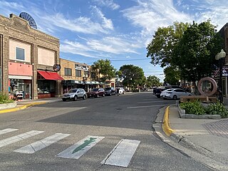
Park Rapids is a city in and the county seat of Hubbard County, Minnesota, United States. It is near Itasca State Park, the source of the Mississippi River, as well as the beginning of the Heartland State Trail. The city was founded in 1890 near the Fish Hook River rapids and is along U.S. Highway 71 and Minnesota State Highway 34. The population was 4,142 at the 2020 census.

Two Harbors is a city in and the county seat of Lake County, Minnesota, United States, along the shore of Lake Superior. The population was 3,633 at the 2020 census. Minnesota State Highway 61 serves as a main route in Two Harbors. Gooseberry Falls State Park is 13 miles (21 km) to the northeast. The city is home to a cargo shipping port for mined iron ore.

Blaine is a suburban city in Anoka and Ramsey counties in Minnesota, United States. Once a rural town, Blaine's population has increased significantly in the last 60 years. For several years, Blaine led the Twin Cities metro region in new home construction. The population was 70,222 at the 2020 census. The city is mainly in Anoka County, and is part of the Minneapolis–Saint Paul metropolitan area.

Chanhassen is a city in Carver County, Minnesota about 16 miles southwest of Minneapolis. A small portion extends into Hennepin County. Located in the southwest Minneapolis–Saint Paul suburbs, there is a mix of suburban residential neighborhoods and rural landscapes. The population was 25,947 at the 2020 census, with a 2024 estimate of 26,469.

The Boundary Waters Canoe Area Wilderness comprises 1,090,000 acres (440,000 ha) of pristine forests, glacial lakes, and streams in the Superior National Forest. Located entirely within the U.S. state of Minnesota at the Boundary Waters, the wilderness area is under the administration of the United States Forest Service. Efforts to preserve the primitive landscape began in the 1900s and culminated in the Boundary Waters Canoe Area Wilderness Act of 1978. The area is a popular destination for canoeing, hiking, and fishing, and is the most visited wilderness in the United States.

Fort Snelling State Park is a state park of the U.S. state of Minnesota, at the confluence of the Mississippi and Minnesota rivers. For many centuries, the area of the modern park has been of importance to the Mdewakanton Dakota people who consider it the center of the Earth. The state park, which opened in 1962, is named for the historic Fort Snelling, which dates from 1820. The fort structure is maintained and operated by the Minnesota Historical Society. The bulk of the state park preserves the bottomland forest, rivers, and backwater lakes below the river bluffs. Both the state and historic fort structure are part of the Mississippi National River and Recreation Area, a National Park Service site.

Glacial Lakes State Park is a state park of Minnesota, USA, approximately 5 miles (8.0 km) south of Starbuck. It was founded in 1963 to preserve some of the remaining rolling prairie which previously covered much of the state. Located in the Leaf Mountains, the park and the area around it contains many glacial landforms created by the Wisconsonian glaciation.

The Mississippi National River and Recreation Area is a 72-mile (116 km) and 54,000-acre (22,000 ha) protected corridor along the Mississippi River through Minneapolis–Saint Paul in the U.S. state of Minnesota, from the cities of Dayton and Ramsey to just downstream of Hastings. This stretch of the upper Mississippi River includes natural, historical, recreational, cultural, scenic, scientific, and economic resources of national significance. This area is the only national park site dedicated exclusively to the Mississippi River. The Mississippi National River and Recreation Area is sometimes abbreviated as MNRRA or MISS, the four-letter code the National Park Service assigned to the area. The Mississippi National River and Recreation Area is classified as one of four national rivers in the United States, and despite its name is technically not one of the 40 national recreation areas.
Lebanon Hills Regional Park is a park in Eagan and Apple Valley, Minnesota. The 1,869-acre (7.56 km2) park, the largest in Dakota County, contains forests, grasslands, marshes, and wetlands. Winter activities include skiing, snowshoeing, ice skating, ice fishing, hiking, and winter mountain biking. Summer activities include mountain biking, canoeing, kayaking, swimming, camping, horseback riding, and hiking.

Lackawanna State Park is a 1,445-acre (585 ha) Pennsylvania state park in Benton and North Abington Townships, Lackawanna County, Pennsylvania in the United States. Lake Lackawanna, a 198-acre (80 ha) man-made lake, is the central focus of recreation at the park. Lackawanna State Park is located near Dalton on Pennsylvania Route 524 just off exit 199 of Interstate 81.

Rice Creek is a tributary of the Mississippi River in the northern suburbs of the Minneapolis–St. Paul metropolitan area of Minnesota in the United States. It is approximately 28 miles (45 km) long and drains a watershed of 201 square miles (520 km2).

The Tryon Creek State Natural Area is a state park located primarily in Portland, in the U.S. state of Oregon. It is the only Oregon state park within a major metropolitan area. The 645-acre (261 ha) park lies between Boones Ferry Road and Terwilliger Boulevard in southwest Portland in Multnomah County and northern Lake Oswego in Clackamas County and is bisected from north to south by Tryon Creek. To the north, the park abuts the Lewis & Clark Law School campus.

Wisconsin, a state in the Midwestern United States, has a vast and diverse geography famous for its landforms created by glaciers during the Wisconsin glaciation 17,000 years ago. The state can be generally divided into five geographic regions—Lake Superior Lowland, Northern Highland, Central Plain, Eastern Ridges & Lowlands, and Western Upland. The southwestern part of the state, which was not covered by glaciers during the most recent ice age, is known as the Driftless Area. The Wisconsin glaciation formed the Wisconsin Dells, Devil's Lake, and the Baraboo Range. A number of areas are protected in the state, including Devil's Lake State Park, the Apostle Islands National Lakeshore, and the Chequamegon–Nicolet National Forest.
The Kabetogama State Forest is a state forest located in Koochiching and Saint Louis counties, Minnesota, United States. The forest borders the Superior National Forest and the Boundary Waters Canoe Area Wilderness to the east, the Sturgeon River State Forest to the south, the Nett Lake Indian Reservation to the west, and Voyageurs National Park to the north. The forest is managed by the Minnesota Department of Natural Resources.

Greenleaf Lake State Recreation Area is a state park unit of Minnesota, USA, currently in development. It includes undeveloped shoreline on both Greenleaf and Sioux Lakes, halfway between the cities of Hutchinson and Litchfield in Meeker County. Portions of the state recreation area (SRA) are open to the public for day-use recreation, but there are no facilities yet on site. The park boundaries were set by the Minnesota Legislature and the state is still acquiring land from willing sellers; two-thirds of the property remain privately owned.

