East 79th station (GCRTA Red Line)

Last updated

E. 79th St.
East 79th station (Red Line).png
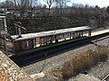
East 79th station entrance in March 2021
General information
Location2700 East 79th Street
Cleveland, Ohio
Coordinates 41°29′10″N81°38′00″W / 41.48611°N 81.63333°W / 41.48611; -81.63333
Owned by Greater Cleveland Regional Transit Authority
Line(s)NS Lake Erie District
Platforms1 island platform
Tracks2
ConnectionsAiga bus trans.svg RTA: 2 [1]
Construction
Structure typeBelow-grade
Bicycle facilities Racks [2]
Accessible Alternative Handicapped Accessible sign.svg Yes [2]
Other information
Website riderta.com/facilities/e79red
History
OpenedMarch 15, 1955;69 years ago (1955-03-15)
Rebuilt2021
Original company Cleveland Transit System
Services
Preceding station GCRTA wordmark logo.svg Rapid Transit Following station
East 55th
toward Airport
Red Line East 105th–Quincy
toward Windermere

East 79th station (signed as East 79th Street) is a station on the RTA Red Line in Cleveland, Ohio. It is located on the west side of East 79th Street between Woodland Avenue and Grand Avenue. The entrance is on the east side of East 79th Street.

Contents

The station opened along with CTS Rapid Transit on March 15, 1955. [3] It originally served nearby industrial facilities, such as the Van Dorn Company, as well as a connection for the East 79th Street bus line. With the closing of most of the industrial facilities adjacent to the station, passenger boardings have decreased so that it has become one of the least used stations on the Red Line. RTA had considered closing the station or moving it to the intersection of Woodland Avenue and Buckeye Road. [4] [5] In early 2020, the RTA made the decision to renovate the station, with construction scheduled to finish in the summer of 2021. [6] The station renovation was completed ahead of schedule, and reopened on March 10, 2021. [7]

Station layout

GStreet levelEntrance/exit, buses
P
Platform level
Lake Erie
District
NS freight service
NS freight service →
Westbound      Red Line toward Airport (East 55th)
Island platform Alternative Handicapped Accessible sign.svg , doors open on the left
Eastbound      Red Line toward Windermere (East 105th–Quincy)

Station photos

Related Research Articles

<span class="mw-page-title-main">Greater Cleveland Regional Transit Authority</span> Public transit agency for the city and suburbs of Cleveland, Ohio, USA

The Greater Cleveland Regional Transit Authority is the public transit agency for Cleveland, Ohio, United States and the surrounding suburbs of Cuyahoga County. RTA is the largest transit agency in Ohio, with a ridership of 22,431,500, or about 75,300 per weekday as of the fourth quarter of 2023.

<span class="mw-page-title-main">Blue Line (RTA Rapid Transit)</span> Light rail line of the RTA Rapid Transit system

The Blue Line is a light rail line of the RTA Rapid Transit system in Cleveland and Shaker Heights, Ohio, running from Tower City Center downtown, then east and southeast to Warrensville Center Blvd near Chagrin Blvd. 2.6 miles (4.2 km) of track, including two stations, are shared with the rapid transit Red Line, the stations have low platforms for the Blue Line and high platforms for the Red Line. The Blue Line shares the right-of-way with the Green Line in Cleveland, and splits off after passing through Shaker Square. All RTA light rail lines use overhead lines and pantographs to draw power.

<span class="mw-page-title-main">Green Line (RTA Rapid Transit)</span>

The Green Line is a light rail line of the RTA Rapid Transit system in Cleveland and Shaker Heights, Ohio, running from Tower City Center downtown, then east to Green Road near Beachwood. 2.6 miles (4.2 km) of track, including two stations, are shared with the rapid transit Red Line; the stations have low platforms for the Green Line and high platforms for the Red Line. The Green Line shares the right-of-way with the Blue Line in Cleveland, and splits off after passing through Shaker Square. All RTA light rail lines use overhead lines and pantographs to draw power.

<span class="mw-page-title-main">Cedar–University station</span> Rapid transit station in Cleveland

Cedar–University station is a station on the RTA Red Line in Cleveland, Ohio. The station is located in University Circle at the foot of Cedar Hill along Cedar Glen Parkway.

<span class="mw-page-title-main">Airport station (GCRTA)</span> Rapid transit station in Cleveland

Airport station is a station on the RTA Red Line in Cleveland, Ohio. It is the western terminus of the Red Line and is located off the lower level below the middle of the baggage claim level of Cleveland Hopkins International Airport.

<span class="mw-page-title-main">West Park station</span> Rapid transit station in Cleveland

West Park station is a station on the RTA Red Line in Cleveland, Ohio. It is located off Lorain Avenue just west of West 143rd Street in the West Park neighborhood.

<span class="mw-page-title-main">West 25th–Ohio City station</span> Rapid transit station in Cleveland

West 25th–Ohio City station is a station on the RTA Red Line in the Ohio City neighborhood of Cleveland, Ohio. It is located at the intersection of West 24th Street, Abbey Avenue and Lorain Avenue, diagonally across Lorain Avenue from the West Side Market.

<span class="mw-page-title-main">Tri-C–Campus District station</span> Rapid transit station in Cleveland

Tri-C–Campus District station is a station on the RTA Rapid Transit system in Cleveland, Ohio, serving the Red, Blue, and Green Lines. It is located just east of East 34th Street near the intersection of East 34th and Broadway, on the north side of the CSX railway tracks, and below the bridge that carries East 34th Street over the railway tracks. Tri-C refers to Cuyahoga Community College.

<span class="mw-page-title-main">Louis Stokes Station at Windermere</span> Rapid transit station in Cleveland

Louis Stokes Station at Windermere is a rapid transit station on the RTA Red Line in East Cleveland, Ohio. It is located on the northwest side of Euclid Avenue between Bryn Mawr and Doan Roads. It is the eastern terminus of the Red Line and the HealthLine, a bus rapid transit route.

<span class="mw-page-title-main">Superior station</span> Rapid transit station in Cleveland

Superior station is a station on the RTA Red Line in East Cleveland, Ohio. It is located on Superior Avenue at the intersection of Emily Street, approximately 1½ blocks west of Euclid Avenue. A small parking lot is located northeast of the station entrance along Emily Street.

<span class="mw-page-title-main">Euclid–East 120th station</span>

Euclid–East 120th was a station on the RTA Red Line in the University Circle neighborhood of Cleveland, Ohio. It was located at the Euclid Avenue and Coltman Road intersection, near the western end of Lake View Cemetery. At the end of service on August 11, 2015, it became the first, and thus far only, station in the history of the RTA to permanently close.

<span class="mw-page-title-main">East 105th–Quincy station</span> Rapid transit station in Cleveland

East 105th–Quincy station is a station on the RTA Red Line in Cleveland, Ohio. It is located in the Fairfax neighborhood on the city's east side. The station has a small entrance on the north side of Quincy Avenue.

<span class="mw-page-title-main">East 55th station</span> Rapid transit station in Cleveland

East 55th station is a station on the RTA Red, Blue, and Green Lines in Cleveland, Ohio. The station entrance is located on the east side of East 55th Street just north of the intersection with Bower Avenue and the eastern terminus of Interstate 490.

<span class="mw-page-title-main">West 65th–Lorain station</span> Rapid transit station in Cleveland

West 65th–Lorain station is a station on the RTA Red Line in Cleveland, Ohio. It is located between Lorain Avenue and Madison Avenue at West 61st Street.

<span class="mw-page-title-main">West Boulevard–Cudell station</span> Rapid transit station in Cleveland

West Boulevard–Cudell station is a station on the RTA Red Line in Cleveland, Ohio. The station is located on the north side of Detroit Avenue at the intersection with West Boulevard in Cleveland's Cudell neighborhood.

<span class="mw-page-title-main">West 117th–Madison station</span> Rapid transit station in Cleveland

West 117th–Madison station is a station on the RTA Red Line in Cleveland, Ohio. It is located on the border between Cleveland and Lakewood.

<span class="mw-page-title-main">Puritas–West 150th station</span> Rapid transit station in Cleveland

Puritas–West 150th station is a station on the RTA Red Line in Cleveland, Ohio. It is located at off West 150th Street just north of Interstate 71. The entrance to the station parking lot is off exit/entrance ramp to Interstate 71. There is also an entrance from West 154th Street, connecting the station directly to Puritas Avenue.

<span class="mw-page-title-main">Brookpark station</span> Rapid transit station in Cleveland

Brookpark station is a station on the RTA Red Line located on the borders of Brook Park and Cleveland, Ohio, USA. It is located along Brookpark Road, west of the intersection of Henry Ford Boulevard and east of the intersection of the Berea Freeway.

<span class="mw-page-title-main">East 79th station (GCRTA Blue and Green Lines)</span> Rapid transit station in Cleveland

East 79th station is a station on the RTA Blue and Green Lines in Cleveland, Ohio. It is located on East 79th Street, south of Holton Avenue.

<span class="mw-page-title-main">HealthLine</span> Bus rapid transit line in Cleveland, Ohio

The HealthLine is a bus rapid transit (BRT) line run by the Greater Cleveland Regional Transit Authority in Cleveland and East Cleveland, Ohio, United States. The line runs along Euclid Avenue from Public Square in downtown Cleveland to the Louis Stokes Station at Windermere in East Cleveland. It began operation on October 24, 2008. Its current name was the result of a naming rights deal with the Cleveland Clinic and University Hospitals of Cleveland. The HealthLine is denoted with a silver color and abbreviated simply as HL on most RTA publications.

References

  1. "Red Line Schedule" (PDF). Greater Cleveland Regional Transit Authority . December 11, 2022. Retrieved May 8, 2023.
  2. 1 2 "E. 79 (Red Line) Rapid Station". Greater Cleveland Regional Transit Authority . Retrieved May 8, 2023.
  3. Exner, Rich (March 14, 2005). "Red Line rapid marks 50 years in service". The Plain Dealer . pp. A1. Retrieved June 2, 2007.
  4. McIntyre, Michael K. (January 6, 1999). "RTA plans new sites, upgrades for Red Line on east side". The Plain Dealer. pp. 1B. Retrieved June 2, 2007.
  5. Sweeney, James F. (October 27, 1999). "RTA considers closing 3 stations on Red Line". The Plain Dealer. pp. 3B. Retrieved June 2, 2007.
  6. "E. 79 St. Closure". April 1, 2020. Archived from the original on March 30, 2020.
  7. "Greater Cleveland Regional Transit Authority". Twitter. Retrieved March 10, 2021.

Commons-logo.svg Media related to East 79th station (GCRTA Red Line) at Wikimedia Commons