Related Research Articles

Lower Saxony is a German state in northwestern Germany. It is the second-largest state by land area, with 47,614 km2 (18,384 sq mi), and fourth-largest in population among the 16 Länder federated as the Federal Republic of Germany. In rural areas, Northern Low Saxon and Saterland Frisian are still spoken, albeit in declining numbers.

Nordfriesland, also known as North Frisia, is the northernmost district of Germany, part of the state of Schleswig-Holstein. It includes almost all of traditional North Frisia, as well as adjacent parts of the Schleswig Geest to the east and Stapelholm to the south, and is bounded by the districts of Schleswig-Flensburg and Dithmarschen, the North Sea and the Danish county of South Jutland. The district is called Kreis Nordfriesland in German, Kreis Noordfreesland in Low German, Kris Nordfraschlönj in Mooring North Frisian, Kreis Nuurdfresklun in Fering North Frisian and Nordfrislands amt in Danish.

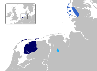
Frisia is a cross-border cultural region in Northwestern Europe. Stretching along the Wadden Sea, it encompasses the north of the Netherlands and parts of northwestern Germany. Wider definitions of "Frisia" may include the island of Rem and the other Danish Wadden Sea Islands. The region is traditionally inhabited by the Frisians, a West Germanic ethnic group.
Friesland is a district (Landkreis) in Lower Saxony, Germany. It is bounded by the districts of Wesermarsch, Ammerland, Leer and Wittmund, and by the North Sea. The city of Wilhelmshaven is enclosed by—but not part of—the district.

East Frisia or East Friesland is a historic region in modern Lower Saxony, Germany. The modern province is primarily located on the western half of the East Frisian peninsula, to the east of West Frisia and to the west of Landkreis Friesland but is known to have extended much further inland before modern representations of the territory. Administratively, East Frisia consists of the districts Aurich, Leer and Wittmund and the city of Emden. It has a population of approximately 469,000 people and an area of 3,142 square kilometres (1,213 sq mi).
Ammerland is a district in Lower Saxony, Germany. It is bounded by the city of Oldenburg and the districts of Oldenburg, Cloppenburg, Leer, Friesland and Wesermarsch.

The Duchy of Oldenburg, named for its capital, the town of Oldenburg, was a state in the north-west of present-day Germany. The counts of Oldenburg died out in 1667, after which it became a duchy until 1810, when it was annexed by the First French Empire. It was located near the mouth of the River Weser.
East Frisian is one of the Frisian languages. Its last surviving dialect is Saterland Frisian spoken in Saterland in Germany.

The Jade Bight is a bight or bay on the North Sea coast of Germany. It was formerly known simply as Jade or Jahde. Because of the very low input of freshwater, it is classified as a bay rather than an estuary.
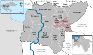
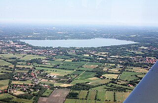
Jümme is a collective municipality (Samtgemeinde) in the district of Leer in the German state of Lower Saxony. It is named after the River Jümme which flows through all three constituent communities. It has an area of 82.34 km2 and a population of 6,421. It is situated in the region of East Frisia. Along with the Samtgemeinde of Hesel, it is one of two in the district. It was formed in the wake of local government reform in 1973. Filsum serves as the administrative centre.

Wangerooge is one of the 32 Frisian Islands in the North Sea located close to the coasts of the Netherlands, Germany and Denmark. It is also a municipality in the district of Friesland in Lower Saxony in Germany.

Land Wursten is a former Samtgemeinde in the district of Cuxhaven, in Lower Saxony, Germany. It was situated approximately 20 km (12 mi) southwest of Cuxhaven, and 15 km (9.3 mi) north of Bremerhaven. Its seat was in the village Dorum. It was disbanded in January 2015, when its member municipalities merged into the new municipality Wurster Nordseeküste.

Hesel is a Samtgemeinde in the district of Leer, in Lower Saxony, Germany. Its seat is in the village Hesel.

The North German Plain or Northern Lowland is one of the major geographical regions of Germany. It is the German part of the North European Plain. The region is bounded by the coasts of the North Sea and the Baltic Sea to the north, Germany's Central Uplands to the south, by the Netherlands to the west and Poland to the east.

This division of Germany into major natural regions takes account primarily of geomorphological, geological, hydrological, and pedological criteria in order to divide the country into large, physical units with a common geographical basis. Political boundaries play no part in this, apart from defining the national border.

A Gulf house, also called a Gulf farmhouse (Gulfhof) or East Frisian house (Ostfriesenhaus), is a type of byre-dwelling that emerged in the 16th and 17th centuries in North Germany. It is timber-framed and built using post-and-beam construction. Initially Gulf houses appeared in the marshes, but later spread to the Frisian geest. They were distributed across the North Sea coastal regions from West Flanders through the Netherlands, East Frisia and Oldenburg as far as Schleswig-Holstein. This spread was interrupted by the Elbe-Weser Triangle which developed a type of Low German house instead, better known as the Low Saxon house.
Land Hadeln is a historic landscape and former administrative district in Northern Germany with its seat in Otterndorf on the Lower Elbe, the lower reaches of the River Elbe, in the Elbe-Weser Triangle between the estuaries of the Elbe and Weser.
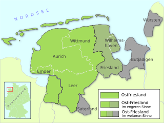
East Frisia is a collective term for all traditionally Frisian areas in Lower Saxony, Germany, which are primarily located on a peninsula between the Dollart and the Jade Bight. Along with West Frisia and North Frisia, it is one of the most commonly used subdivisions of Frisia.
The Dümmer Geest Lowland is a natural region unit of the 3rd level in northwest Germany that mainly extends over southwestern Lower Saxony with a small area over the border in North Rhine-Westphalia. Its uniqueness consists in the very varied juxtaposition of different landscape elements of the Northern Lowlands of which the Dümmer Geest Lowland is a part.
References
53°09′00″N7°42′00″E / 53.1500°N 7.7000°E
| | This Lower Saxony location article is a stub. You can help Wikipedia by expanding it. |