East Hesse Depression

Last updated

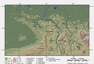
The East Hesse Depression is one of two fault troughs trending from north-northeast to south-southwest in the state of Hesse, Germany. Like the West Hesse Depression, it is a series of separate depressions that form a natural corridor and have been an important historical trade route. [1]

Hesse State in Germany

Hesse or Hessia, officially the State of Hesse, is a federal state (Land) of the Federal Republic of Germany, with just over six million inhabitants. The state capital is Wiesbaden; the largest city is Frankfurt am Main.

Germany Federal parliamentary republic in central-western Europe

Germany, officially the Federal Republic of Germany, is a country in Central and Western Europe, lying between the Baltic and North Seas to the north, and the Alps to the south. It borders Denmark to the north, Poland and the Czech Republic to the east, Austria and Switzerland to the south, France to the southwest, and Luxembourg, Belgium and the Netherlands to the west.

West Hesse Depression

The West Hesse Depression is part of the West Hesse Highlands and Lowlands region in the north of the German state of Hesse. Like the East Hesse Depression, it is a series of separate depressions that form a natural corridor and have been an important historical trade route.

The corridor follows the valley of the Kinzig passing through Hersfeld, Fulda and Bebra, then continues down the Fulda valley to Kassel and finally runs along the course of the Leine to Göttingen. [1] This trough is bounded to the west by the Vogelsberg-Meißner Axis [1] or Hessian Central Uplands [2] and to the east by the Thuringian Highland and Rhön Mountains.

Kinzig (Main) right tributary of the Main in Hesse, Germany

The Kinzig is a river, 87 kilometres long, in southern Hesse, Germany. It is a right tributary of the Main. Its source is in the Spessart hills at Sterbfritz, near Schlüchtern. The Kinzig flows into the Main in Hanau. The Main-Kinzig-Kreis (district) was named after the river. The towns along the Kinzig are Schlüchtern, Steinau an der Straße, Bad Soden-Salmünster, Gelnhausen, and Hanau. The Kinzig is first recorded in 815 A.D. as Chinzicha.
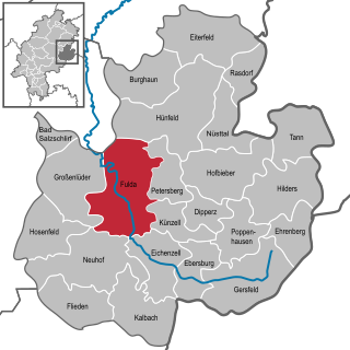
Fulda Place in Hesse, Germany

Fulda is a city in Hesse, Germany; it is located on the river Fulda and is the administrative seat of the Fulda district (Kreis). In 1990, the town hosted the 30th Hessentag state festival.
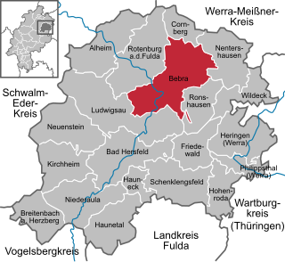
Bebra Place in Hesse, Germany

Bebra is a small town in Hersfeld-Rotenburg district in northeastern Hesse, Germany.

Related Research Articles

Fulda (district) District in Hesse, Germany

Fulda is a Kreis (district) in the north-east of Hesse, Germany. Neighboring districts are Hersfeld-Rotenburg, Wartburgkreis, Schmalkalden-Meiningen, Rhön-Grabfeld, Bad Kissingen, Main-Kinzig, Vogelsbergkreis.

Fulda (river) head river of the Weser in Hesse, Germany

The Fulda is a river of Hesse and Lower Saxony, Germany. It is one of two headstreams of the Weser. The Fulda is 220.4 kilometres (137.0 mi) long.

Rhenish Hesse

Rhenish Hesse or Rhine-Hesse is a region and a former government district in the German state of Rhineland-Palatinate, made up of those territories west of the Upper Rhine river that from 1816 were part of the Grand Duchy of Hesse and of the People's State of Hesse until 1945. The hilly countryside is largely devoted to vineyards, comprising the Rheinhessen wine region.

Kaufungen Forest mountains in Germany

The Kaufungen Forest is a range of steep, wooded hills straddling the border between the states of Hesse and Lower Saxony in central Germany. It takes its name from the town Kaufungen.

Ludwigsau Place in Hesse, Germany

Ludwigsau is a community in Hersfeld-Rotenburg district in northeastern Hesse, Germany. With an area of 112 km² it is Hesse’s biggest community by land area.

Ehrenberg, Hesse Place in Hesse, Germany

Ehrenberg is a municipality in the district of Fulda, in Hesse, Germany.

The Frankfurt–Bebra railway runs from Bebra to Frankfurt am Main via Fulda, Gelnhausen, Hanau and Offenbach am Main in south central Germany. The southern section between Fulda and Frankfurt is known as the Kinzig Valley railway due to the route it follows through the Kinzig Valley.

Central Uplands

The Central Uplands is one of the three major natural regions of Germany and covers most of the land area of the country. To the north lies the North German Plain or Northern Lowland; to the south, the Alps and the Alpine Foreland.

Lower Saxon Hills mountain range

The Lower Saxon Hills are one of the 73 natural regions in Germany defined by the Federal Agency for Nature Conservation (BfN). Geographically it covers roughly the same area as the Weser Uplands in its wider sense.

Dresden Basin valley

The Dresden Basin is a roughly 45 km long and 10 km wide area of the Elbe Valley between the towns of Pirna and Meißen. The city of Dresden lies in the Dresden Basin.

West Hesse Highlands mountains in Germany

The West Hesse Highlands, also known as the West Hessian Lowlands and Highlands, refers to a heavily forested region of the Central Uplands in Germany that lies mostly within the state of Hesse, between those elements of the Rhenish Massif right of the Rhine in the west, the Weser Uplands to the north, the Hessian Central Uplands to the east and the Wetterau to the south.

The East Hesse Highlands describes a heavily wooded range of hills lying mainly in the German state of Hesse, but also extending a little way into Lower Saxony to the north, Thuringia to the east and Bavaria to the southeast. The region is sandwiched between the West Hesse Depression to the west, the Weser Uplands to the north, the Thuringian Basin to the northeast, the northwestern edge of the Thuringian Forest to the east, the Spessart to the south and the Wetterau to the southwest.

The Paderborn Plateau in central Germany is, geologically speaking, the southeastern element of the Westphalian Bight and, at the same time, the largest limestone and karst landscape in Westphalia.

The Bebra–Fulda railway is a continuously double track and electrified main line.

The Ore Mountain Basin or Erzgebirge Basin is a natural region in the German federal state of Saxony, that is part of the Saxon Lowland. To the north it borders on the Mulde Loess Hills and to the south on several natural regions in the Saxon Highlands and Uplands.

Schlüchtern station railway station in Schlüchtern, Germany

Schlüchtern station is a station in the town of Schlüchtern in the German state of Hesse on the Kinzig Valley Railway. The station is classified by Deutsche Bahn (DB) as a category 4 station.

Middle Hesse one of three planning regions in the German state of Hesse

The region of Middle Hesse is one of three planning regions in the German state of Hesse, alongside North and South Hesse. Its territory is identical with that of the administrative province of Gießen and covers the counties of Limburg-Weilburg, Lahn-Dill-Kreis, Gießen, Marburg-Biedenkopf and Vogelsbergkreis. The Middle Hesse Regional Assembly, which decides on the regional plan, currently consists of 31 members chosen by the five counties and the three towns with special status: Gießen, Marburg and Wetzlar. The regional assembly has tasked the governing president (Regierungspräsident) with delivering regional management. The Mid-Hesse Regional Management Association was founded on 22 January 2003.

The Hessian Central Uplands are an area of volcanic highland in Central Hesse in Germany. It is also referred to as the Vogelsberg-Meissner Axis.

References

  1. 1 2 3 Dickinson, Robert E (1964). Germany: A regional and economic geography (2nd ed.). London: Methuen, p. 512. ASIN   B000IOFSEQ.
  2. Elkins, T H (1972). Germany (3rd ed.). London: Chatto & Windus, 1972, p. 223. ASIN   B0011Z9KJA.