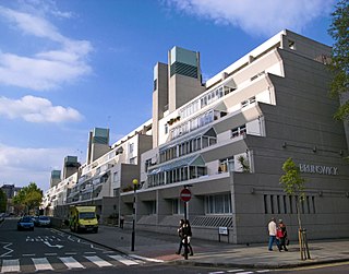
The Brunswick Centre is a grade II listed residential and shopping centre in Bloomsbury, London, England. It is located between Brunswick Square and Russell Square and is administratively in the London Borough of Camden.

The Reversing Falls are a series of rapids on the Saint John River located in Saint John, New Brunswick, Canada, where the river runs through a narrow gorge before emptying into the Bay of Fundy.

The Nashwaak River, located in west-central New Brunswick, Canada, is a tributary of the Saint John River. It is 113 kilometres long. The river rises from Nashwaak Lake and flows south and east through uninhabited land and rapids to the community of Nashwaak. From Nashwaak, the Nashwaak River flows southeast to Nashwaak Bridge and Taymouth, then south through several rural communities such as Durham Bridge, the historic town of Nashwaak Village and Penniac before it reaches the town of Marysville. It flows into the Saint John River opposite downtown Fredericton.
5th Canadian Division Support Base Gagetown, formerly known as and commonly referred to as CFB Gagetown, is a large Canadian Forces Base covering an area over 1,100 km2 (420 sq mi), located in southwestern New Brunswick. It is the biggest facility in Eastern Canada, and Canada's second-largest facility.
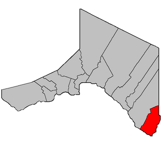
Portland-Simonds is a provincial electoral district for the Legislative Assembly of New Brunswick, Canada. It was originally created for the 1995 provincial election as Saint John Portland and its boundaries were altered slightly in 2006. It in the 2013 redrawing of boundaries its boundaries were moved significantly southward into territory previously part of Saint John East; though the boundaries commission did not recommend a name change, a committee of the legislative assembly later voted to change the name to Portland-Simonds. The riding name refers to Portland and Simonds Parish in Saint John County.

The Westmorland Street Bridge is a bridge crossing the Saint John River in Fredericton, New Brunswick, Canada. Opened on 19 September 1981, the Westmorland Street Bridge is an extension of Westmorland Street in Fredericton's central business district and connects with Route 105 in Nashwaaksis, a neighbourhood of Fredericton since municipal amalgamation in the 1970s.

The Saint John Harbour Bridge is three-span crossing of Saint John Harbour at the mouth of the Saint John River in Saint John, New Brunswick, Canada. It opened in 1968.

The Oromocto River is a tributary of the Saint John River in southwest New Brunswick, Canada.
The Kingston Peninsula is a peninsula in southern New Brunswick, Canada, located between the Saint John River and the Kennebecasis River in Kings County.

The New Brunswick Museum, located in Saint John, New Brunswick, is Canada's oldest continuing museum. The New Brunswick Museum was incorporated as the "Provincial Museum" in 1929 and received its current name in 1930, but its history goes back much further. Its lineage can be traced back another 88 years to 1842 and to the work of Dr. Abraham Gesner.
Point Lepreau is a cape in southwestern New Brunswick, Canada.

The Great Fire of Saint John was an urban fire that devastated much of Saint John, New Brunswick in June 1877, destroying two-fifths of the city.
Saint-André is a geographic parish in Madawaska County, New Brunswick, Canada.
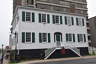
Loyalist House is a museum and National Historic Site located in uptown Saint John, New Brunswick, Canada. It was the home of the prosperous Merritt family, who occupied it from its completion in 1817 until 1958. It was taken over by the New Brunswick Historical Society in 1961. Its address is 120 Union Street.
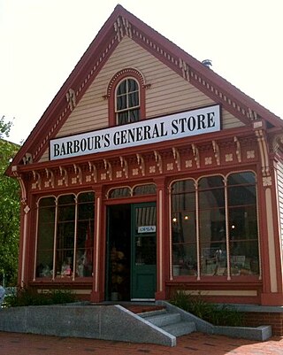
Barbour's General Store was a museum and tourist hub in Saint John, New Brunswick. It was an authentic 19th-century general store building, preserved and used to recreate a Victorian-era educational experience for visitors. It was located at the intersection of King Street and Prince William Street just outside the Trinity Royal Historic Conservation Area in the city's uptown. On August 22, 2015 the shop was re-opened to the public as a functioning business and local information centre. On June 13, 2023 the building was proposed to demolish after a fire in January 2022. It was dismantled in July 2023.

The Trinity Royal Heritage Conservation Area is a historic district in Saint John, New Brunswick's uptown. The City of Saint John designated the area as the city's first heritage conservation area in 1982; it has since expanded in area. Surrounding the Trinity Anglican Church, the area includes several National Historic Sites of Canada within its boundaries. Much of the area consists of Victorian brick buildings raised after The Great Fire of Saint John, New Brunswick that destroyed much of the city's central peninsula in 1877.
Westfield is a geographic parish in Kings County, New Brunswick, Canada.

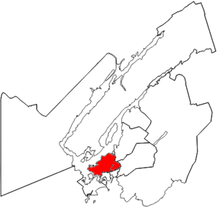
Greater Saint John is a metropolitan area surrounding Saint John, New Brunswick, Canada. It has a population of 126,202.
Musquash is a Canadian rural community in Saint John County, New Brunswick. It is located 5 km (3.1 mi) west southwest of the community of Prince of Wales in Musquash Parish.
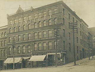
Manchester, Robertson & Allison was a large department store in Saint John, New Brunswick, Canada. Founded in 1866 by James Manchester, James F. Robertson and Joseph Allison, the store, which contained several departments, was in business until closing in 1973 and being replaced by the Brunswick Square.
