
Clearwater National Forest with headquarters on the Nez Perce Reservation at Kamiah is located in North Central Idaho in the northwestern United States. The forest is bounded on the east by the state of Montana, on the north by the Idaho Panhandle National Forest, and on the south and west by the Nez Perce National Forest and Palouse Prairie.

Clearwater is a district municipality in the North Thompson River valley in British Columbia, Canada, where the Clearwater River empties into the North Thompson River. It is located 124 km (77 mi) north of Kamloops. The District of Clearwater was established on December 23, 2007, making it one of the newest municipalities in British Columbia. It is near Wells Gray Provincial Park and is surrounded by the Trophy Mountains, Raft Mountain and Dunn Peak.

The Bougainville campaign was a series of land and naval battles of the Pacific campaign of World War II between Allied forces and the Empire of Japan, named after the island of Bougainville. It was part of Operation Cartwheel, the Allied grand strategy in the South Pacific. The campaign took place in the Northern Solomons in two phases. The first phase, in which American troops landed and held the perimeter around the beachhead at Torokina, lasted from November 1943 through November 1944.
Cape Torokina is a promontory at the north end of Empress Augusta Bay, along the central part of the western coast of Bougainville, in Papua New Guinea.

The Courtney Campbell Causeway is the northernmost bridge across Old Tampa Bay, carrying State Road 60 between Clearwater, Florida in Pinellas County and Tampa, Florida in Hillsborough County.

The Clearwater River is the largest tributary of the North Thompson River, joining it at the community of Clearwater, British Columbia. The Clearwater rises from glaciers in the Cariboo Mountains and flows in a mostly southerly direction for 201 km (125 mi) to the North Thompson. Its entire course, except the last 5 km (3 mi), is within Wells Gray Provincial Park. Its confluence with the North Thompson is protected by North Thompson River Provincial Park.

Mount Ray, also known as Ray Mountain, is a subglacial mound in Wells Gray Provincial Park, British Columbia, Canada. Mount Ray last erupted during the Pleistocene. It is part of the Wells Gray-Clearwater volcanic field.
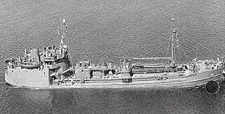
USS Mettawee (AOG-17) was a Mettawee-class T1 tanker type gasoline tanker acquired by the U.S. Navy for the dangerous task of transporting gasoline to warships in the fleet, and to remote Navy stations.

Clearwater Lake is one of six large lakes in Wells Gray Provincial Park in east-central British Columbia, Canada,. The Clearwater River enters the lake at its north end, flowing from Hobson Lake and Azure Lake, and also drains the lake. There are several small streams that flow into Clearwater Lake, but it has no significant tributaries.

Spahats Creek Falls, also called Spahats Falls, is a waterfall on Spahats Creek within Wells Gray Provincial Park of British Columbia, Canada. Common references place the falls at around 60 m (197 ft) tall, but taking into account the second tier, it is closer to 75–80 meters tall. It is a popular stop for tourists and especially motorcoach tours since it is only 10 km (6.2 mi) off the busy Yellowhead Highway.
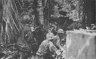
The Battle of the Coconut Grove was a battle between United States Marine Corps and Imperial Japanese Army forces on Bougainville. The battle took place on 13–14 November 1943 during the Bougainville campaign, coming in the wake of a successful landing around Cape Torokina at the start of November, as part of the advance towards Rabaul as part of Operation Cartwheel.

The Numa Numa Trail is a trail on Bougainville in Papua New Guinea that runs from Numa Numa on the east coast over the central mountains of Bougainville to Torokina on the western coast.
The Piva Trail is a trail on Bougainville, part of the Solomons chain, that runs alongside the Piva River, connecting to the East West Trail and the Numa Numa Trail.

Wells Gray Provincial Park is a large wilderness park located in east-central British Columbia, Canada. The park protects most of the southern, and highest, regions of the Cariboo Mountains and covers 5,250 square kilometres. It is British Columbia's fourth largest park, after Tatshenshini, Spatsizi and Tweedsmuir.

Trophy Mountain is a mountain in east-central British Columbia, Canada, located in the south-east region of Wells Gray Provincial Park. The Clearwater River flows to the west, Raft River to the east and Spahats Creek to the south. Trophy Mountain is part of the Shuswap Highland. There are nine summits in the group and the highest is 2,577 m (8,455 ft). Battle Mountain and Table Mountain are the closest summits to the north and Raft Mountain is immediately south. Trophy Mountain was given its name by Dan Case, a big-game hunting guide in the area.
The Ream Wilson Clearwater Trail, also known as Clearwater East West Trail, is a 13-mile bicycling and pedestrian trail corridor under development in Clearwater, Florida. It connects areas near the Gulf of Mexico at Clearwater Beach to areas near Tampa Bay at Safety Harbor. Parking is available where the trail runs by the Long Center, Coachman Ridge Park, Northeast Coachman Park, Cliff Stephens Park, the Eddie C. Moore Recreation Complex, Del Oro Park, and Cooper's Bayou Park. The trail also connects to North-South trails including the Pinellas Trail and (proposed) Florida Progress Trail.
State Road 590 is an east–west commercial and commuter highway serving central Pinellas County, within Clearwater and Safety Harbor. It runs from running from Alt US 19 in Clearwater east to State Road 580 in Safety Harbor, and is a scenic route in much of Safety Harbor.

The Orange Belt Railway was a 3 ft narrow gauge railroad established in 1885 by Russian exile Peter Demens in Florida. It was one of the longest narrow gauge railroads in the United States at the time of its completion in 1888, with a mainline 152 miles (245 km) in length between Sanford and St. Petersburg. It carried citrus, vegetables, and passengers; and it interchanged with two standard gauge lines: the Jacksonville, Tampa and Key West Railway at Lake Monroe, and the Florida Central and Peninsular Railroad at Lacoochee.

The Clearwater Subdivision is a railroad line owned by CSX Transportation in the Tampa Bay region of Florida. The line begins just east of downtown Tampa in Gary and heads north through some of Tampa's suburban neighborhoods. In Sulphur Springs, the Clearwater Subdivision turns and runs west through Oldsmar, where it crosses Tampa Bay. It briefly shifts south running through Safety Harbor, and then heads west again to Clearwater. In Clearwater, it turns southeast, running through Largo and Pinellas Park before terminating at Fifth Avenue North in St. Petersburg near Tropicana Field. The distance from Gary to St. Petersburg along the line is 48.6 miles (78.2 km). At the line's north end it continues from the Tampa Terminal Subdivision and at its south end the track comes to an end.