
Afghanistan, officially the Islamic Emirate of Afghanistan, is a landlocked country at the crossroads of Central and South Asia. It is bordered by Pakistan to the east and south, Iran to the west, Turkmenistan and Uzbekistan to the north, and Tajikistan and China to the northeast. Occupying 652,864 square kilometres (252,072 sq mi), the country is predominately mountainous with plains in the north and the southwest that are separated by the Hindu Kush mountains. Its population as of 2020 is 31.4 million, composed mostly of ethnic Pashtuns, Tajiks, Hazaras, and Uzbeks. Kabul serves as its capital and largest city.

Khyber Pakhtunkhwa, often abbreviated as KP or KPK and formerly known as the North-West Frontier Province, is one of the four provinces of Pakistan. It is located in the northwestern region of the country, along the Afghanistan–Pakistan border.

The International Security Assistance Force (ISAF) was a multinational military mission in Afghanistan from 2001 to 2014. It was established by United Nations Security Council Resolution 1386 pursuant to the Bonn Agreement, which outlined the establishment of a permanent Afghan government following the U.S. invasion in October 2001. ISAF's primary goal was to train the Afghan National Security Forces (ANSF) and assist Afghanistan in rebuilding key government institutions; however, it gradually took part in the broader war in Afghanistan against the Taliban insurgency.

Herat is one of the thirty-four provinces of Afghanistan, located in the north-western part of the country. Together with Badghis, Farah, and Ghor provinces, it makes up the north-western region of Afghanistan. Its primary city and administrative capital is Herat City. The province of Herat is divided into about 17 districts and contains over 1,000 villages. It has a population of about 2,187,169, making it the second most populated province in Afghanistan behind Kabul Province. The population is multi-ethnic but largely Persian-speaking.

Zabul is one of the 34 provinces of Afghanistan, located in the south of the country. It has a mostly rural population of about 391,000. Zabul became an independent province from neighbouring Kandahar in 1963. Historically, it was part of the Zabulistan region. Qalat serves as the capital of the province.

Afghanistan is divided into 34 provinces. The provinces of Afghanistan are the primary administrative divisions. Each province encompasses a number of districts or usually over 1,000 villages.

Faryab is one of the thirty-four provinces of Afghanistan, which is located in the north of the country bordering neighboring Turkmenistan. It has a population of about 1,109,223, which is multi-ethnic and mostly a tribal society. The province encompasses 15 districts and over 1,000 villages. The capital of Faryab province is Maymana. It also borders Jowzjan Province, Sar-e Pol Province, Ghor Province and Badghis Province.
Kandahār is one of the thirty-four provinces of Afghanistan, located in the southern part of the country, sharing a border with Pakistan, to the south. It is surrounded by Helmand in the west, Uruzgan in the north and Zabul Province in the east. Its capital is the city of Kandahar, Afghanistan's second largest city, which is located on the Arghandab River. The greater region surrounding the province is called Loy Kandahar. The Emir of Afghanistan sends orders to Kabul from Kandahar making it the de facto capital of Afghanistan, although the main government body operates it Kabul. All meetings with the Emir take place in Kandahar, meetings excluding the Emir are in Kabul.

Khost is one of the 34 provinces of Afghanistan, located in the eastern part of the country. To the east, Khost Province is bordered by North Waziristan and Kurram in Pakistan. Khost Province used to be part of Paktia Province in the past, and the larger region surrounding Khost is still called Loya Paktia.

Logar is one of the 34 provinces of Afghanistan located in the eastern section of the country. It is divided into seven districts and contains hundreds of villages. Puli Alam is the capital of the province. As of 2021, Logar has a population of about 442,037. It is a multi-ethnic tribal society, with a Tajik and Pashtun majority.

Nangarhār also called Nangrahar or Ningrahar, is one of the 34 provinces of Afghanistan, located in the eastern part of the country and bordering Logar, Kabul, Laghman and Kunar provinces as well as having an international border with Pakistan. It is divided into 22 districts and has a population of about 1,735,531, the third highest of the country's 34 provinces. The city of Jalalabad is the capital of Nangarhar province.
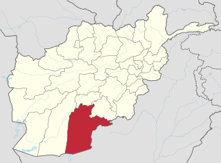
Nimruz or Nimroz is one of the 34 provinces of Afghanistan, located in the southwestern part of the country. It lies to the east of the Sistan and Baluchestan Province of Iran and north of Balochistan, Pakistan, also bordering the Afghan provinces of Farah and Helmand. It has a population of about 186,963 people. The province is divided into five districts, encompassing about 649 villages.

Daykundi, also spelled as Daikundi, Daikondi or Dai Kundi, is one of the thirty-four provinces of Afghanistan, located in the central part of the country. It has a population of about 516,504, which is a Hazara Province.

Panjshir is one of the thirty-four provinces of Afghanistan, located in the northeastern part of the country containing the Panjshir Valley. The province is divided into seven districts and contains 512 villages. As of 2021, the population of Panjshir province was about 173,000. Bazarak serves as the provincial capital.

Badakhshan Province is one of the 34 provinces of Afghanistan, located in the northeastern part of the country. It is bordered by Tajikistan's Gorno-Badakhshan in the north and the Pakistan-administered Lower and Upper Chitral and Gilgit-Baltistan in the southeast. It also has a 91-kilometer (57-mile) border with China in the east.
Kunar is one of the 34 provinces of Afghanistan, located in the northeastern part of the country. Its capital is Asadabad. Its population is estimated to be 508,224.
The following lists events that happened during 2004 in Afghanistan.
The following lists events that happened in 2013 in Afghanistan.
Events in the year 2017 in Afghanistan.

The COVID-19 pandemic in Afghanistan is part of the worldwide pandemic of coronavirus disease 2019 caused by severe acute respiratory syndrome coronavirus 2. The virus was confirmed to have spread to Afghanistan when its index case, in Herat, was confirmed on 24 February 2020.
