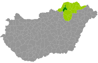
Edelény Subregion

Last updated

Edelény Subregion Borsod-Abaúj-Zemplén sixth largest of the subregions of Hungary. Area  : 783,21 km². Population  : 36 155 (2009) [1]

Subregions of Hungary

Subregions of Hungary were subdivisions of Hungary, dividing the twenty counties of Hungary into 175 administrative subregions. The subregions were abolished and replaced by 198 districts in 2013.

Area quantity that expresses the extent of a two-dimensional surface or shape, or planar lamina, in the plane

Area is the quantity that expresses the extent of a two-dimensional figure or shape, or planar lamina, in the plane. Surface area is its analog on the two-dimensional surface of a three-dimensional object. Area can be understood as the amount of material with a given thickness that would be necessary to fashion a model of the shape, or the amount of paint necessary to cover the surface with a single coat. It is the two-dimensional analog of the length of a curve or the volume of a solid.

Population All the organisms of a given species that live in the specified region

In biology, a population is the number of all the organisms of the same group or species, which live in a particular geographical area, and have the capability of interbreeding. The area of a sexual population is the area where inter-breeding is potentially possible between any pair within the area, and where the probability of interbreeding is greater than the probability of cross-breeding with individuals from other areas.

Settlements:

Abod Village in Borsod-Abaúj-Zemplén, Hungary

Abod is a village in Borsod-Abaúj-Zemplén county, Hungary.

Balajt is a village in Borsod-Abaúj-Zemplén county, Hungary.

Becskeháza Place in Borsod-Abaúj-Zemplén, Hungary

Becskeháza is a village in Borsod-Abaúj-Zemplén county, Hungary.
See also

Related Research Articles

Edelény Place in Northern Hungary, Hungary

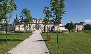
Edelény is a town in Borsod-Abaúj-Zemplén county, Northern Hungary. It lies in the valley of Bódva River, 25 km (16 mi) north of the county seat, Miskolc. The historic L'Huillier-Coburg Palace is located there.

Ilyinka is the name of several inhabited localities in Russia.

Omastiná municipality of Slovakia

Omastiná is a village and municipality in Bánovce nad Bebravou District in the Trenčín Region of north-western Slovakia.

Keren Subregion Subregion in Anseba, Eritrea

Keren Subregion is a subregion in the northwestern Anseba region of Eritrea. Its capital lies at Keren (Cheren).

Ampitatsimo Place in Alaotra-Mangoro, Madagascar

Ampitatsimo is a town and commune in Madagascar. It belongs to the district of Ambatondrazaka, which is a part of Alaotra-Mangoro Region. The population of the commune was estimated to be approximately 13,000 in a 2001 commune census.

Haydarli, Lori Place in Lori Province, Armenia

Haydarli, is a village in the Lori Province of Armenia.

Dobroteasa Commune in Olt County, Romania

Dobroteasa is a commune in Olt County, Romania. It is composed of four villages: Batia, Câmpu Mare, Dobroteasa and Vulpești.

Remetea Mare Commune in Timiș, Romania

Remetea Mare is a commune in Timiș County, Romania. It is composed of two villages, Ianova (Temesjenő) and Remetea Mare.

Topólno Village in Masovian, Poland

Topólno is a village in the administrative district of Gmina Gąbin, within Płock County, Masovian Voivodeship, in east-central Poland. It lies approximately 4 kilometres (2 mi) south-east of Gąbin, 20 km (12 mi) south of Płock, and 85 km (53 mi) west of Warsaw.

Sokolniki Suche Village in Masovian, Poland

Sokolniki Suche is a village in the administrative district of Gmina Wieniawa, within Przysucha County, Masovian Voivodeship, in east-central Poland. It lies approximately 3 kilometres (2 mi) north-west of Wieniawa, 12 km (7 mi) east of Przysucha, and 94 km (58 mi) south of Warsaw.

Čím is a village and municipality in Příbram District in the Central Bohemian Region of the Czech Republic.

Hét is a village in Borsod-Abaúj-Zemplén County in northeastern Hungary.

Lénárddaróc is a village in Borsod-Abaúj-Zemplén County in northeastern Hungary.

Viszló is a village in Borsod-Abaúj-Zemplén County in northeastern Hungary.

Sajóecseg is a village in Borsod-Abaúj-Zemplén County in northeastern Hungary.

Zádorfalva is a village in Borsod-Abaúj-Zemplén County in northeastern Hungary.

Sajónémeti is a village in Borsod-Abaúj-Zemplén County in northeastern Hungary.

Edelény District Districts of Hungary in Borsod-Abaúj-Zemplén

Edelény is a district in northern part of Borsod-Abaúj-Zemplén County. Edelény is also the name of the town where the district seat is found. The district is located in the Northern Hungary Statistical Region.

Kazincbarcika District Districts of Hungary in Borsod-Abaúj-Zemplén

Kazincbarcika is a district in north-western part of Borsod-Abaúj-Zemplén County. Kazincbarcika is also the name of the town where the district seat is found. The district is located in the Northern Hungary Statistical Region.

Ózd District Districts of Hungary in Borsod-Abaúj-Zemplén

Ózd is a district in western part of Borsod-Abaúj-Zemplén County. Ózd is also the name of the town where the district seat is found. The district is located in the Northern Hungary Statistical Region.

References

Coordinates: 48°23′N20°47′E / 48.383°N 20.783°E / 48.383; 20.783

Geographic coordinate system Coordinate system

A geographic coordinate system is a coordinate system that enables every location on Earth to be specified by a set of numbers, letters or symbols. The coordinates are often chosen such that one of the numbers represents a vertical position and two or three of the numbers represent a horizontal position; alternatively, a geographic position may be expressed in a combined three-dimensional Cartesian vector. A common choice of coordinates is latitude, longitude and elevation. To specify a location on a plane requires a map projection.