Related Research Articles

Scotland Yard is the headquarters of the Metropolitan Police, the territorial police force responsible for policing Greater London's 32 boroughs. Its name derives from the location of the original Metropolitan Police headquarters at 4 Whitehall Place, which had its main public entrance on the Westminster street called Great Scotland Yard. The Scotland Yard entrance became the public entrance, and over time "Scotland Yard" came to be used not only as the common name of the headquarters building, but also as a metonym for the Metropolitan Police Service (MPS) itself and police officers, especially detectives, who serve in it. The New York Times wrote in 1964 that, just as Wall Street gave its name to New York's financial district, Scotland Yard became the name for police activity in London.

The M90 is a motorway in Scotland. It runs from Junction 1A of the M9 motorway, south of the Queensferry Crossing, to Perth. It is the northernmost motorway in the United Kingdom. The northern point goes to the western suburbs of Perth at Broxden. A small part of the M90 was originally numbered as the M85 motorway.

There has long been debate over the exact location of the geographical centre of the United Kingdom, and its constituent countries, due to the complexity and method of the calculation, such as whether to include offshore islands, and the fact that erosion will cause the position to change over time. There are two main methods of calculating this "centre": either as the centroid of the two-dimensional shape made by the country, or as the point farthest from the boundary of the country. These two methods give quite different answers.

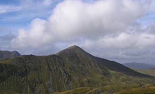
Bidean nam Bian is the highest peak in a group of mountains south of Glen Coe and north of Glen Etive in the Scottish Highlands. With a height of 1,150 metres (3,770 ft), it is a Munro and the highest point in Argyll. It is a complex mountain with many ridges and subsidiary peaks, one of which, Stob Coire Sgreamhach, is classified as a separate Munro.

Angus is a county constituency of the House of Commons of the Parliament of the United Kingdom. It elects one Member of Parliament (MP) by the first-past-the-post voting system. It is currently represented by Dave Doogan of the Scottish National Party who has been the MP since 2019.

Eileach an Naoimh, also known as Holy Isle, is an uninhabited island in the Inner Hebrides of the west coast of Scotland. It is the southernmost of the Garvellachs archipelago and lies in the Firth of Lorne between Mull and Argyll. The name is Gaelic for "rocky place of the saint".

Beinn Ìme is the highest mountain in the Arrochar Alps of Argyll, in the Southern Highlands of Scotland. It reaches 1,011 metres (3,317 ft), making it a Munro.
Ben Vorlich is a mountain in the Southern Highlands of Scotland. It lies south of Loch Earn and Ardvorlich, and a short distance north of the neighbouring mountain Stùc a' Chroin. Ben Vorlich reaches a height of 985 metres (3,232 ft), making it a Munro.
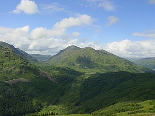
Ben Vorlich is a mountain in the Arrochar Alps of Argyll, in the Southern Highlands of Scotland. It reaches 943 metres (3,094 ft), making it a Munro. It lies between Loch Lomond and Loch Sloy. Ben Vorlich is the highest point of the historic county of Dunbartonshire.

Meall a' Bhùiridh (IPA:[ˈmauɫ̪ˈaˈvuːɾʲɪʝ]) is a mountain on the edge of Rannoch Moor in the Highlands of Scotland. It lies near the top of Glen Coe and Glen Etive, overlooking the Kings House Hotel inn and the A82 road. The Glencoe Ski area is located on the northern slopes of the peak.
Kirkcaldy Rugby Football Club is a rugby union club from Kirkcaldy, Fife, Scotland. The men's side currently plays in Scottish National League Division Two and the women's side currently plays in Scottish Womens Midlands & East One.

Banks o' Dee Football Club is a Scottish football club from the city of Aberdeen that plays in the Scottish Highland Football League.

Gaor Bheinn, also known in English as Gulvain, is a mountain in the Northwest Highlands of Scotland. It is in Lochaber, south of Loch Arkaig and north of the road west of Fort William. It is composed of banded granite and shaped like a letter Y, with two tops connected by a ridge running from northeast to southwest, with the northern top 6 m higher than the one to the south. Crags drop at either end, and steep slopes fall away to either side. The south ridge path is really a stream bed, so in wet conditions an easier if longer ascent from Na Socachan is to walk up Allt a Choire Reidh towards Gualann nan Osna and climb the south top's north-west ridge.

Beinn an Dòthaidh, is a mountain in the Bridge of Orchy hills of Argyll and Bute, Scotland. It is located beside the more popular Beinn Dòrain. The two hills are frequently climbed together from the bealach between them, which is easily accessed from the Bridge of Orchy railway station.
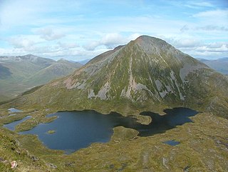
Sgùrr Eilde Mòr or Sgùrr Èilde Mhòr is a mountain in the Mamores range of the Grampian Mountains, Scotland. It is 6 kilometres north-east of Kinlochleven. It is a steep, conical peak of scree and quartzite boulders, capped with a layer of schist. With a height of 1010 m (3314 ft) it is classed as a Munro, so is popular with hillwalkers. It is most commonly climbed from Kinlochleven by way of a stalker's path which leads to a col at Coire an Lochan, and then by either the south or the west ridge - both routes involving an ascent of steep, bouldery terrain.

Beinn Sgulaird or Beinn Sguiliaird is a mountain in the Lorn region of the Scottish Highlands, between Glen Creran and Glen Etive. It has a height of 937 m (3074 ft) and is classed as a Munro. The mountain takes the form of a long ridge which runs from southwest to northeast, three kilometres of which lie above 800 m. Hillwalkers commonly traverse the ridge from north to south, as this gives the best views of the Hebrides to the west, in particular the Isle of Mull. While most walkers start from Glen Creran to the west, an ascent from Glen Etive is also possible.

Beinn a' Chreachain is a Scottish mountain, with a conical top, to the north-west of Loch Lyon.

West Highland College is a college of further and higher education in the West Highlands of Scotland. The college is part of the University of the Highlands and Islands and operates from a number of college centres across the area, at Auchtertyre, Broadford, Fort William, Kilchoan, Kinlochleven, Mallaig, Portree, Strontian and Ullapool.
Ardpeaton is a settlement in Argyll and Bute, Scotland, on the shore of Loch Long, with a population under 1000.
Glenmallan is a settlement in Argyll and Bute, Scotland, on the shore of Loch Long. It has a population of under 1000, and its coordinates are latitude 56° 07' 34" N, longitude 4° 48' 54" W.
References
- ↑ "collinsmaps.com, retrieved 22 May 2013". Archived from the original on 28 June 2013. Retrieved 22 May 2013.
- ↑ McNair, Andrew (1 December 2017). "Loch Lomond woman hitting the right notes in dual classical music and boxing career". dailyrecord. Retrieved 14 November 2019.
56°06′34″N4°41′47″W / 56.109336°N 4.696345°W
| | This Scotland-related article is a stub. You can help Wikipedia by expanding it. |