Troms (pronounced [trʊms] or Romsa or Tromssa is a county in northern Norway. It borders Finnmark county to the northeast and Nordland county in the southwest. Norrbotten Län in Sweden is located to the south and further southeast is a shorter border with Lapland Province in Finland. To the west is the Norwegian Sea.
Måsøy is a municipality in Finnmark county, Norway. The administrative centre of the municipality is the village of Havøysund. Other villages include Ingøy, Måsøy, Slåtten, and Gunnarnes. The municipality is located on the mainland as well as several islands.
Karmøy is a municipality in Rogaland county, Norway. It is southwest of the city of Haugesund in the traditional district of Haugaland. The administrative centre of the municipality is the town of Kopervik.

Stord is a municipality in Hordaland county, Norway. It is located in the traditional district of Sunnhordland. Stord is sometimes called "Norway in miniature" since it has such a variety of landscapes: coastline, fjords, forests, agricultural land, and mountain areas. The administrative centre of the municipality is the town of Leirvik, which is also the largest town in the municipality and the whole region of Sunnhordland. Leirvik was declared a town in 1997. Other population centres in the municipality include the large village of Sagvåg and the smaller villages of Litlabø and Grov.
Frei is a former municipality in Møre og Romsdal county, Norway. It is located in the present-day Kristiansund Municipality between the Kvernesfjorden and Freifjorden. The municipality existed from 1838 until 2008 and upon its dissolution, it included the island of Frei and the smaller surrounding islands, totaling about 65 square kilometres (25 sq mi).

Ballangen is a municipality in Nordland county, Norway. It is part of the traditional district of Ofoten. The administrative centre of the municipality is the village of Ballangen. Other villages in the municipality include Bjørkåsen, Kjeldebotn, Kobbvika, and Skarstad.

Moskenes is a municipality in Nordland county, Norway. The municipality comprises the southern part of the island of Moskenesøya in the traditional district of Lofoten. The administrative centre of the municipality is the village of Reine. Other villages include Sørvågen, Hamnøy, and Å.

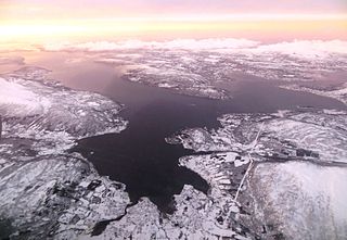
Harstad (Norwegian) or Hárstták (Northern Sami) is the second-most populated municipality in Troms county, Norway. It is mostly located on the large island of Hinnøya. The municipal center is the town of Harstad, the most populous town in Central Hålogaland, and the third-largest in all of Northern Norway. The town was incorporated in 1904. Villages in the municipality include Elgsnes, Fauskevåg, Gausvik, Grøtavær, Kasfjord, Lundenes, Nergården and Sørvika.

Tranøy is a municipality in Troms county, Norway. The municipality is situated on the southern coast of the large island of Senja. The administrative centre is the village of Vangsvik in the eastern part of the municipality. Other important villages include Stonglandseidet, Skrollsvika, and Å.

Berg is a municipality in Troms county, Norway. The administrative centre of the municipality is the village of Skaland. Other villages include Finnsæter, Mefjordvær, and Senjahopen. The municipality is located on the western part of the large island of Senja.
Senja (Norwegian) or Sážžá (Northern Sami) is an island and future municipality in Troms county, Norway. At 1,586.3-square-kilometre (612.5 sq mi), it is the second largest island in Norway. It has a wild, mountainous outer (western) side facing the Atlantic, and a mild and lush inner (eastern) side. The island is governed by four municipalities: Torsken, Tranøy, Lenvik, and Berg, however in on 1 January 2020, the four municipalities are scheduled to be merged into one large Senja Municipality. The island of Senja had 7,864 inhabitants as of 1 January 2017. Most of the residents live along the eastern coast of the island, with Silsand being the largest urban area on the island. The fishing village of Gryllefjord on the west coast has a summer-only ferry connection to the nearby island of Andøya: the Andenes–Gryllefjord Ferry.

Valsøyfjord is a village and a former municipality in Møre og Romsdal county, Norway. The village is located along the Arasvikfjorden, just west of the Valsøyfjorden. The European route E39 highway runs through the village, just west of the Valsøy Bridge. There are about 800 people living in Valsøyfjord and the area surrounding the local Valsøyfjorden, and most of the people are working in agriculture and public services.

Rore is a lake in the municipalities of Grimstad and Arendal in Aust-Agder county, Norway. This lake, which is used as a reservoir, lies mostly in Grimstad. There is a public beach area at the southern end of the lake, near the village of Roresand. The lake is located in the Landvik area, about 3 kilometres (1.9 mi) from the center of the town of Grimstad.
Stemshaug is a village and former municipality in Møre og Romsdal county, Norway. The village is located on the mainland along the southern shore of the Torsetsundet in the present-day Aure Municipality. The former municipality encompassed the northeastern part of Aure, including the eastern part of Skardsøya island and the Tjeldbergodden area on the mainland. The very old Stemshaug Church is located in the village. The village of Stemshaug was the administrative centre of the municipality.

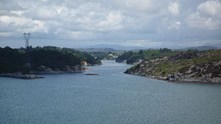
The Herøyfjorden or Herøyfjord is a fjord which bisects the municipality of Herøy in Møre og Romsdal county, Norway. The fjord is about 8 kilometres (5.0 mi) long and about 2 kilometres (1.2 mi) wide, between the islands of Bergsøya and Gurskøya. The fjord has a maximum depth of 175 metres (574 ft).
Moskenesøya is an island at the southern end of the Lofoten archipelago in Nordland county, Norway. The 186-square-kilometre (72 sq mi) island is shared between Moskenes Municipality and Flakstad Municipality.
Gurskøya or Gurskøy is an island in Møre og Romsdal county, Norway. The 137-square-kilometre (53 sq mi) island is shared by the municipalities of Sande and Herøy. The villages of Gursken, Larsnes, and Moldtustranda are located on the island. The southern part of the island was historically part of the municipality of Rovde.

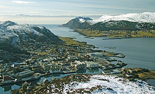
Bergsøy or Bergsøya is an island in the municipality of Herøy in Møre og Romsdal county, Norway. The island is the location of the municipal center of Fosnavåg as well as the Eggesbønes industrial area. The island is connected to other islands via a network of bridges. The Nerlandsøy Bridge connects it to the island Nerlandsøya and a small road bridge connects it to Leinøya. The Flåvær islands lie to the south. The highest point on the island is Igesundshetta which is 216 metres (709 ft) above sea level. The island has an area of 7.6 square kilometres (2.9 sq mi).