Eierland

Last updated
Eierland (here spelled "Eyerland") on a map originally published in 1702. PaysBas delisle 1743 fragment.jpg
Eierland (here spelled "Eyerland") on a map originally published in 1702.

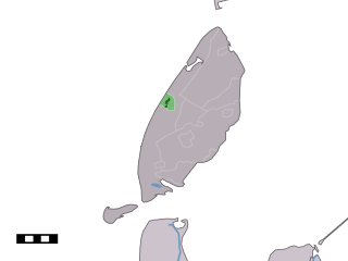
Eierland (Dutch pronunciation: [ˈɛiərlɑnt] ) is a former island in the Netherlands. It is now the northern part of the island of Texel. The name means "egg land", named for the seagull eggs that were collected on the island and sent to Amsterdam.

Netherlands Constituent country of the Kingdom of the Netherlands in Europe

The Netherlands is a country located mainly in Northwestern Europe. The European portion of the Netherlands consists of twelve separate provinces that border Germany to the east, Belgium to the south, and the North Sea to the northwest, with maritime borders in the North Sea with Belgium, Germany and the United Kingdom. Together with three island territories in the Caribbean Sea—Bonaire, Sint Eustatius and Saba— it forms a constituent country of the Kingdom of the Netherlands. The official language is Dutch, but a secondary official language in the province of Friesland is West Frisian.

Texel Municipality and island in North Holland, Netherlands

Texel is a municipality and an island with a population of 13,641 in the province of North Holland in the Netherlands. It is the largest and most populated island of the West Frisian Islands in the Wadden Sea. The island is situated north of Den Helder, northeast of Noorderhaaks, also known as "Razende Bol" and southwest of Vlieland.

The island of Eierland was a part of Vlieland until the 13th century, when it became a separate island. During the 16th century, a sand bank grew in the sea arm between Texel and Eierland, which eventually was submerged only at extremely high tide. In 1629 and 1630, a dam was built connecting the two islands, and Eierland ceased to exist as a separate island.

Vlieland Municipality in Friesland, Netherlands

Vlieland is a municipality and island in the northern Netherlands. The municipality of Vlieland has one major town, Oost-Vlieland. It is the second most sparsely populated municipality in the Netherlands, after Schiermonnikoog.

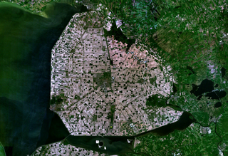
The shallow waters between the two islands were sold to a group of developers led by trader Nicolaas de Cock from Antwerp in 1835. Within twenty weeks, a dyke was built around this area, and a polder was created, the Eierlandse Polder. This meant a significant enlargement of the island of Texel.

Antwerp Municipality in Flemish Community, Belgium

Antwerp is a city in Belgium, and is the capital of Antwerp province in Flanders. With a population of 520,504, it is the most populous city proper in Belgium, and with 1,200,000 the second largest metropolitan region after Brussels.

Polder low-lying tract of land enclosed by embankments (barriers) known as dikes

A polder is a low-lying tract of land enclosed by dikes that form an artificial hydrological entity, meaning it has no connection with outside water other than through manually operated devices. There are three types of polder:

  1. Land reclaimed from a body of water, such as a lake or the sea bed
  2. Flood plains separated from the sea or river by a dike
  3. Marshes separated from the surrounding water by a dike and subsequently drained; these are also known as koogs especially in Germany

The lighthouse of Texel, the Eierland Lighthouse, is located on the northern tip of the former island. This area was formerly known as het Engels Kerkhof, the English Cemetery. Many sailors from nearby shipwrecks were buried here.

Eierland Lighthouse lighthouse in the Netherlands

The Eierland Lighthouse is a lighthouse on the northernmost tip of the Dutch island of Texel. It is named for the former island Eierland.

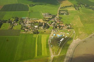
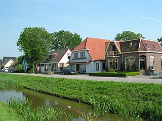
The village of De Cocksdorp (named after Nicolaas de Cock) and the hamlets Midden-Eierland and Zuid-Eierland are located in the Eierlandse Polder.

De Cocksdorp Place in Noord-Holland, Netherlands

De Cocksdorp is a town in the Dutch province of North Holland. It is a part of the municipality of Texel, and lies about 25 km north of Den Helder.

Related Research Articles

North Holland Province of the Netherlands

North Holland is a province of the Netherlands located in the northwestern part of the country. It is situated on the North Sea, north of South Holland and Utrecht, and west of Friesland and Flevoland. In 2015, it had a population of 2,762,163 and a total area of 2,670 km2 (1,030 sq mi).

Wieringen Former municipality in North Holland, Netherlands

Wieringen is part of the new municipality of Hollands Kroon, established in 2012 in the province of North Holland in the Netherlands. It is a former municipality in this province, with its name appearing in records of the late 9th and early 10th century. From 1200 it was known as an island, also named Wieringen, which was separated by water from the mainland during one of the disastrous storm floods towards the end of the late Middle Ages that changed the coastline. By draining, dikes and landfill from 1924 to 1932, the island was rejoined to the mainland.

Frisian Islands archipelago in the Wadden Sea

The Frisian Islands, also known as the Wadden Islands or the Wadden Sea Islands, form an archipelago at the eastern edge of the North Sea in northwestern Europe, stretching from the northwest of the Netherlands through Germany to the west of Denmark. The islands shield the mudflat region of the Wadden Sea from the North Sea.

Dagebüll Place in Schleswig-Holstein, Germany

Dagebüll is a municipality located at the west coast of Schleswig-Holstein in the Nordfriesland district, Germany. Today's Dagebüll was created in 1978 as a merger of the municipalities of Fahretoft, Juliane-Marien-Koog and Waygaard. Dagebüll used to be a Hallig, the oldest houses were built on artificial dwelling hills which in parts can still be seen today. In 1704 the area was secured by sea dikes.

De Koog Place in North Holland, Netherlands

De Koog is a town in the Dutch province of North Holland. It is a part of the municipality of Texel, and lies about 17 km north of Den Helder. It is the chief centre of tourism on the island, surrounded with many hotels and campgrounds. The village is located on the North Sea coast of the island. Only two narrow lines of dunes separate the village from the beach.

Wieringerwaard Town in North Holland, Netherlands

Wieringerwaard is a polder and a village in the municipality of Hollands Kroon in the Dutch province of North Holland. Wieringerwaard was formerly a separate municipality, until it merged with Barsingerhorn in 1970.

Zuid Haffel is a polder and village in the northwest of the Netherlands. It is located on the island of Texel, North Holland. Texel is also the municipality of the place.

Den Burg Place in North Holland, Netherlands

Den Burg is a town in the Dutch province of North Holland. It is a part of the municipality of Texel on the island of the same name, and lies about 12 km north of Den Helder.

Bommenede former town and former municipality in Zeeland

Bommenede or Bommenee is a former island, village, and municipality in the Netherlands, located about 5 km east of the city of Brouwershaven.

Driehuizen is a hamlet in the Dutch province of North Holland. It is located on the island of Texel, about 2 km southwest of the town of Den Burg. The name comes from the fact that from nowhere suddenly three houses were erected in the same time, probably in the 16th century.

Klaaswaal farm village in the Netherlands

Klaaswaal is a village and former municipality in the Dutch province of South Holland. It is centrally located on one of the island Hoeksche Waard. Klaaswaal was a separate municipality until 1984, when it was merged with Numansdorp to form the municipality Cromstrijen.

De Vennip is a former municipality in the Dutch province of South Holland. It consisted of a small area of land east of Hillegom, and a large part of the Haarlemmermeer lake, including the island of Beinsdorp.

Kruispolderhaven is a rural village located in the eastern Zeelandic Flanders portion of the Dutch province of Zeeland. Its name originates from its location at the eastern tip of the Kruispolder, a "crossed" polder adjacent to a seaport on the southern bank of the Western Scheldt estuary.

Dunes of Texel National Park

Dunes of Texel National Park is a national park located on the North-Holland island of Texel in the Netherlands. All dune systems on the western side of the island and the large coastal plains on both the northern and southern points of the island are part of the park. The park covers approximately 43 km2 (17 sq mi) and attained national park status in 2002. The visitor center is located in the natural history museum Ecomare.

The city of Leeuwarden, Friesland, the Netherlands has had at least 130 windmills over the centuries. Only one, the Froskepôlemolen survives today within Leeuwarden. Six other mills which have stood in Leeuwarden survive elsewhere in the Netherlands. The mills had a wide range of industrial and agricultural uses. The industrial uses include the processing of bark for tanning leather, the fulling of cloth, the production of cement, the production of dyes, the extraction of oil, the grinding of tobacco to produce snuff, the production of gunpowder, and the sawing of timber. Agricultural uses include the milling of buckwheat, oats, rye and wheat, the processing of chicory, the production of pearl barley, and the pumping of water.

De Pijp Neighbourhood of Amsterdam in North Holland, Netherlands

De Pijp is a neighbourhood of Amsterdam, Netherlands. It is located directly south of Amsterdam's city centre and it is part of the borough Amsterdam-Zuid, in a part of the city known as the Old South. It is served by De Pijp metro station. Most streets in De Pijp are named after Dutch painters, like Jan Steen, Frans Hals, Ruysdael and Vincent van Gogh. Diamantbuurt, Nieuwe Pijp and Oude Pijp are the three districts composing the area.

Marne (estuary)

The Marneslenk (Dutch), or Marneslinke (Frisian), or Marne estuary, was a former estuary in western Friesland south of Harlingen, now reclaimed to be farmland. It formed around the year 300 AD, when rising sea levels also enlarged the Almere lake to the southwest, and formed the Middelzee to the east. The Marneslenk had its mouth on the Vlie and stretched southeasterly to the area of Tirns and then headed east to the Middelzee. Between 1100 and 1300 AD the watercourse was reclaimed and turned into fields by the construction of dykes. One such dyke is the Pingjumer Gulden Halsband. The Bedelaarsvaart (Bidlersfeart) and Harnzerfeartis are what remains of this watercourse nowadays.

References

Abraham Jacob van der Aa Dutch writer and academic

Abraham Jacob van der Aa was a Dutch writer best known for his dictionaries, one of notable people and the other of notable places in the Netherlands.

Coordinates: 53°10′N4°50′E / 53.16°N 4.84°E / 53.16; 4.84